Multi-hazard Early Warning Center (MHEWC)
The Standard Operating Procedure (SOP) of the African Center of Meteorological Applications for Development (ACMAD) Multi-Hazard Continental Advisory Canter
Design, Installation, and Developed by : Z M Sajjadul Islam, Early Warning Expert at ACMAD, Consultant
Contents
1.0 Technical Background of ACAMD Continental Advisory Center (Situation Room). 4
1.1 Enhance the capacity of ACMAD in multi-hazard risk-informed tool development. 4
2.0 Exixting ICT structures of ACAMD Continental Multi-hazard Advisory & Warning Center: 6
2.1 Existing ICT Structures of ACMAD Continental Multi-hazard Advisory & Warning. 6
2.2 PUMA Nowcasting input satellites, types, and functions. 7
3.0 Proposed Structure of ACAMD Continental Multi-hazard Advisory Center: 10
3.1 The main component of ACAMD Continental Advisory Center: 11
3.2 Other built-in components of ACAMD Continental Advisory Center: 11
4.0 Setup of Situation Room & SoPs for exchanging information. 13
4.1 The myDEWETRA 2.0 System Installation : 13
4.2 Situation Room Components : 14
6.1 Multi-hazard early warning product development process : 21
6.2 Types of Products is intended to produce. 22
7.0 Data Coordination Mechanism with other center. 23
7.1 Proposed Data Linkage with Tropical Storm warning center at La Réunion : 23
7.2 Data Linkage with AUC, ICPAC, RECs, NHMS, Emergency management Focal Point: 23
7.3 Proposed Data Linkage with WMO designated center: 247.4 Way forward: 25
1.0 Introduction :
The standard operating procedure (SOP) of Africa Multi-Hazard Early Warning and Action System for DRR Continental Situation Room is designed for the African Center of Meteorological Applications for Development (ACMAD) and simultaneously being linked and interacting with other prioritized centers e.g. African Union Commission (AUC), and ICPAC. This SOP being well articulated with a set of the guideline of technical and functional aspects of how myDEWETRA & EUMETCast tools shall be facilitating in real-time and time-span hydro-meteorological data to be integrated into the system, data collecting, processing, real-time risk analysis and supporting multi-hazard risk-informed tools to AUC, its organs and Member States(MS), and Disaster Risk Management Authorities at the continent level with the given priority of risk-informed preparedness plans, and, response, and post-disaster recovery and reconstruction mechanisms.
The Standard Operating Procedures (SOP) of ACMAD Situation Room is a toolkit that is expected to provide integrated and strategic guidance to Situation Room Officers (forecasters), Weather department of ACMAD, AUC, and IPAC situation rooms, and other operators of the regions to operating robustly.
This SOP provides the strategies for the effective data capture, data process, time-spanning forecasting products, early warnings, and relevant climate information and services to stakeholders engaged in disaster and climate emergencies e.g. , DRM focal points, humanitarian actors, NHMS organizations, vulnerable service sectors at the country and national level of the Africa Continent.
SOP being intended to give the leverage of data exchange mechanism, data communication, coordination, in-house knowledge collaboration, and tools sharing among the AUC, ACMAD, ICPAC, and other connected agencies.
Apart from the business as usual of weather-watching, the CIMA foundation intended to upgrading the ACMAD watch center to provide multi-hazard early warnings ( MHEWS) by deploying the myDEWETRA platform. The mechanism being envisaged to establish MHEWS and to set up a 24/7 situation room at ACMAD center with the installation of open-source platform myDEWETRA. This platform is developed by CIMA Research Foundation and owned by the Department of Civil Protection. Technically, the platform encompasses multiple weather satellite-based integrated remotely sensed hydro-meteorological data capture, data processing and providing observations of weather parameters, multi-hazards forecasting, and model analysis.
More importantly, the establishment of myDEWETRA based MHEWS at the ACMAD Situation Room and standardized operation of the platform will improve climate and weather information services to the relevant stakeholders for the climate-resilient sustainable development of the Sahel region and the beyond.
1.1 Background
The main hazards affecting the African continent are related to extreme weather events. These include heavy rainfall, strong winds, floods, rainfall-triggered landslides, tropical cyclones, drought. The continent is affected by other hazards such as earthquakes, volcanoes, tsunamis, extreme heat, etc. The Continental Watch report will offer a general overview of all the potential natural threats, assessing with a predefined color coding (green, yellow, orange, and red) related to their possible severity.
These Standard Operating Procedures are divided into two parts. The first one is for developing and disseminating CWs and the second is about developing and disseminating SitReps by ACMAD and ICPAC. Pertinent to performing the technical early warning operations and tools, the situation room shall be issuing two kinds of reports, according to the fixed schedule agreed. The first report is the Continental bulletin (hereinafter, CW) twice a week. This bulletin shall reflect a scan, observe and forecast of the weather and climate system of the whole continent that could potentially lead to any disaster and providing advisories for DRM. Other early warning institutions will be consulted as the situation dictates to provide information for the continental watch reports.
The second part of the process of situation room to supplement AUC an event Situation Report (abbreviated as SitRep) highlighting the standing conditions of an on-set of just the disasters triggered by extreme weather events, over the ongoing or potentially be impending hazard events, (e.g., an approaching Tropical Cyclone), the incrementally to intensifying of flooding situation or fresh flooding to down streams territories, etc. SitRep should be prepared immediately after the disaster event (or in advance in case of any hydro-meteorological events, e.g. Tropical Cyclones) or pre-emptive to trigger a hazard event to disaster.
The African Union commission situation room will be responsible for the collection of information, analysis of the information, and dissemination of the reports to all stakeholders or the general public when deemed to do so.
1.1 Context of SOP for ACMAD Situation Room for producing climate information and
services
It is however highly mentionable that the stakeholders are now demanding a detailed landscape of spatially analyzed best risks informed (the climate riks and vulnerability GIS-based spatial analytical maps) tools for supporting policy, program, project planning, and decision making desks for evidencebased development project planning, design, implementation, monitoring and largely to achieve the SDG goals.
The primary objective of the MHEWS is to enhance the capacity of ACMAD to produce spatial maps/tools and to timely supplement to AUC, its sub-organ, regions, and county focal points to take early actions for impending disasters.
The goal of the SOP of the ACMAD warning center is to leverage the development of the strategic tool and upgrading ACMAD led time-series weather observation, forecasting, rapidly developing thunderstorm (RDT), and real-time based other multi-hazard early warning products in more upgraded ways by defining the approach.
Improving Nowcast: By using the multiple sources of satellite-based real-time weather observations, consequence analysis with leveraging additional analytical tooms e.g. myDEWETRA platform, Global Flood Awareness System (GloFAS), and access to EUMETSat Cast at the Situation room of ACMAD.
Improving Forecasts: At the outset of installed MHEWS and upgraded situation room at ACMAD center being enhanced the capacity of ACMAD in producing different range real-time and different range of forecasts (RDT, Short-range, medium-range, long-range, decadal, monthly, and seasonal) and outlooks at the precision level. Accuracy of different range forecasts is being highly demanded by the AUC, its organs/sub-organs, NHMS organizations, DRM actors at the national and local level.
Impact-based Forecasts: A customized forecasting system to be scaled-up by the deployment of the myDEWETRA platform, Global Flood Awareness System (GloFAS), and access to EUMETSat Cast at the Situation room of ACMAD.
Multi-Hazard Early Warnings: As the weather and climatic phenomena being rapidly changing of climatic system and perturbations over the early and African continent particularly, the need for MHEWS are mounting. The SOP is intended to set out the procedures of MHEWS at the ACMAD with the existing system in place.
Coordination, Communications, and Advocacy: Objectives to establish communication strategies with AUC and beyond for strengthening ties with stakeholders for knowledge, information sharing, sharing the effectiveness and efficacy of climate information products and services for matching the needs of NHMS organizations. Sharing the best practices, actively engage with focal points/nodal agencies, local governments, sector departments, local actors, media outlets, and build the value proposition being offered by the situation room.
2.0 Defined Roles of SOP:
Forecasters: ACMAD situation rooms being equipped to facilitate forecasters with for observation (space satellite-based observation and terrestrial synoptic stations based) and acquisition of atmospheric weather parameters from different interfaces e.g. myDEWETRA, PUMA, GLOFAS, GTS links. Forecasters’ jobs as forefront watchdog to weathers parameters and analyzing. Forecasters regular activities to monitor atmospheric conditions every hour and provide nowcasting.
Synoptic Analysis Team: Verify the fundamentals of weather analysis and forecasting, interpretation of surface observations( with WMO synoptic stations), satellite-based observations, verifying the multi-modal forecasts simultaneously, running forecast ensemble process, forecast diagnosis, forecast verification and finalize the forecast.
Data Analysis Team: Find the available climate datasets from the DCPC, WIS, fetch data, and readily made them available to develop multipurpose climate modeling.
Climate Team: Analysing of short-range forecast( 3 Days, 4 days ), analysis of meteorological data from other regional WMO centers (DCPCs, WIS), Center for climate prediction center ( CPC), EUMETSAT stations, etc and provide a different range of products Medium-range Forecasts (decadal to two weeks) – Tropical Cyclones, Floods, etc. Extended-range Forecasts (two weeks and beyond) – Droughts and Severe Weather etc. Extended-range Forecasts (two weeks and beyond) – Droughts and Severe Weather. Monthly and Seasonal Forecasts – Droughts, weather anomalies, agricultural droughts, seasonal variation of climates. Analysis of climatic variables and prepare detailed forecast maps on monthly, seasonal and yearly, and beyond.
Multi-hazard risk analysis and Mapping Team: Using hazard forecasting bulleting, multi-hazard mapping expert responsibilities to analyze the sector-specific multi-hazards exposure, risks, and vulnerabilities and produce customized early warning maps for the sectors.
Climate Model Team: Responsibilities torun the model and develop forecast, long-range forecast bulleting, specialized sector-specific customized bulletins, weather outlook, monthly, yearly outlook, and multi-hazard maps.
2.1 Afrcian Continent Weather Observation Process :
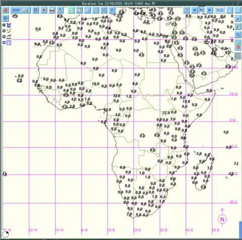
7 Days Forecasts: WAVEWATCH III (WW3) Model: Using the THREDDS NetCDF Subset Service is an excellent tool for giving a forecast for consecutive 7 days.
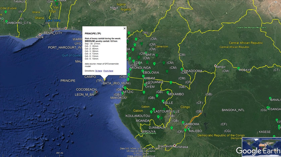
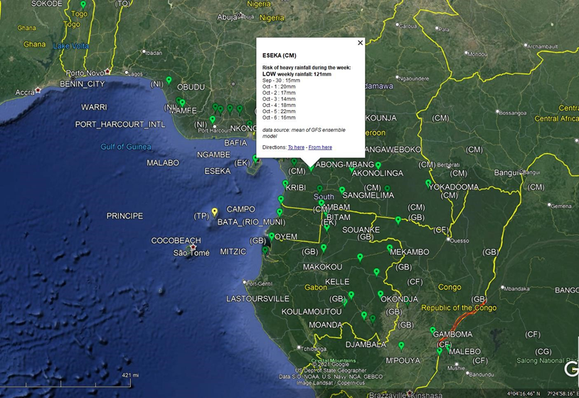
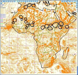
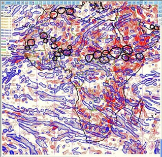
Figure : Green Bubble showing the normal thresholds precipitation projections
Process : The thredd server Linux ContOS crontab scripts automatically generate kmz file for forecast and warnings for every seven consecutive days. Kmz file can be viewed by google earth and also can be imported to ArcGIS /QGIS software and it shows an application with two feature classes e.g. bubble (point features ) with the thresholds of green, yellow, orange, and red for showing the intensity of rainfall forecasts over the consecutive 7 days and the total sum of rainfall in mm.
7 Days warning :
http://154.66.220.45:8080/thredds/catalog/WW3/7day/catalog.html
Source: Catalog http://154.66.220.45:8080/thredds/catalog/WW3/1day/warning/catalog.html
Source: Catalog http://154.66.220.45:8080/thredds/catalog/WW3/7day/warning/catalog.html
3.0 African Continent Forecast & Bulleting Development Process :
3.1: African Continental Forecasting Process :
Step 1: Analysis of past weather :
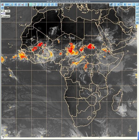
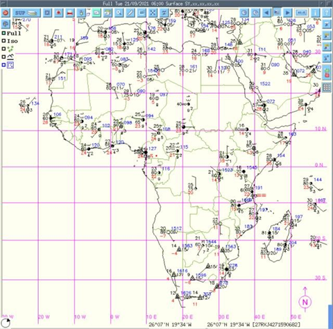
a) Analysis of Satellite images :
- The purpose is it review the forecasting accuracy by reviewing the last forecasted time lead(days) of satellite captured images from the sky. Review the weather system being prevailed those days and examine all parameters previous days and identify the point of forecasting gaps.
- Analysis of past convective system of decaying and increasing that need to consider for the next level of the forecast. Forecasters regularly use real-time nowcasting for this analysis.
- Analysis of forecast and statistical forecast data
PUMA nowcast
Analysis of the corresponding Synoptic chart: Rerecorded by the ground-based WMO-
designated synoptic ground observation weather stations across the continents ( around 1000 according to WMO).
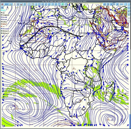
Step 2: Analysis of ITD (Inter-Tropical Discontinuity) :
Analysis of the limit between dry air ( harmattan[1] ) and moist air( monsoon), wind flow, deep convention, mean sea level pressure, etc. The diurnal cycle of ITD[2], i.e. the interface at the ground between moist monsoon air and dry Harmattan air, is an important factor in the West African monsoon system. During the whole of 2006, high-resolution groundbased remote-sensing measurements were performed in the area of Djougou, Benin, which made it possible to observe the ITD and the associated sharp gradient of temperature and humidity in detail.
[1] https://en.wikipedia.org/wiki/Harmattan
[2] Article in Quarterly Journal of the Royal Meteorological Society · January 2010 3 The unit for pressure is hectopascals (hPa)
Analysis of the movement of monsoon flux, the moist air coming from the south and dry air coming from the north. Deep convection occurs south of the ITD.
Step 3: Analysis of the synoptic drivers :
- Analysis of Winds ( at 925 hPa3 to analyze the monsoon flux ) velocity and direction
- Analysis of heat low ( area of low pressure which is the center of action of meteorology )
- Analyzing 850 hPa to observe wind vorticity
- 700 hPa to observe African easterly waves (AEWs) and wind direction
- Analyzing 600 hPa wind direction, AEWs, and African easterly jet (AEJ) which is very important for the convection
- Geopotential 500 hPa and temperature at 850 hPa
- Analysis 200 hPa to observe Tropical Easterly Jet (JET) and STJ ( Sub Tropical Jet)
Step 4: Analysis of deep convection parameters
winds Vertical velocity
Divergence and convergence of winds
Inter Tropical Convergence Zone (ITCZ) for deep convection areas
Analysis Relative Humidity at any levels
Analyzing the Wet bulb bulb potential temperature
Some other parameters and index
Vertical velocity of the wind
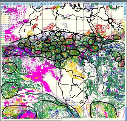
Areas of deep convection are those where all parameters are favorable
Step 5: Analysis Deep Convection over Africa through areas common values of followings;
a) Convergence (at low level) , Convergence( at medium level ) , Divergence( high level ) structures to updraft airmass
- Good value CAPE
- Very good value of Vertical velocity
- High values of relative humidity through all the troposphere
- Taking in account of synoptic drivers
Area with high vertical velocity
Low & mid-level convergence or divergence (airmass)
Convective Available Potential Energy (CAPE)[1] CAPE stands for convective available potential energy, and it is a useful tool for determining the severe weather potential at a given location at a given time. Using CAPE to Forecast Severe Weather.
[1] https://study.com/academy/lesson/convective–available–potential–energy–cape–definition–use–in–forecasting.html
Step 6: Prepare Forecast map and Bulletin :
• Determine areas where deep convection is supposed to occur with the type of rainfall and its intensity and showing strong winds and giving warnings of weather based on heavy rainfall and strong winds. Forecasting of convection
Step 7: Forecast verification
Satellite images to indicate where deep convection occurs and synoptic data give an indication of registered rainfall at the synoptic (WMO) station across the African continent ( around 1000 stations).
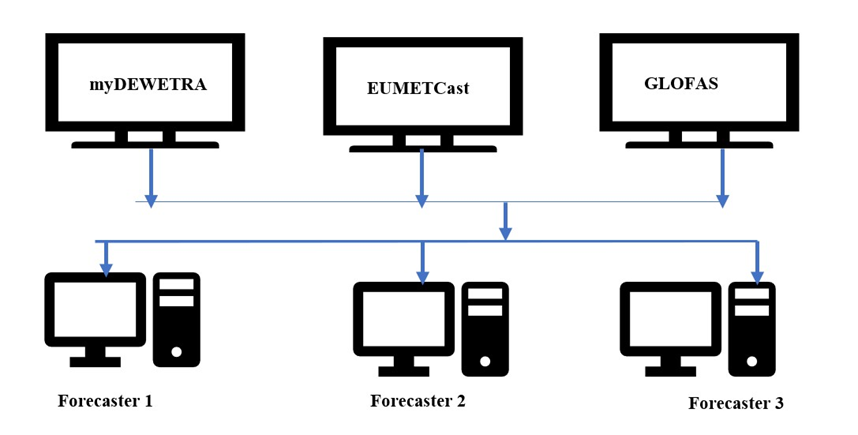
6.0 Standard Operating Procedure (SOP) of Extreme weather forecasting and Multi-hazard Advisory, Risk & Vulnerability Analysis by using myDEWETRA and other tools :
The myDEWETRA open-source platform having synchronized whether satellite-based tools for serving multiple purposes of weather observation, hydro-meteorological forecasts( short-medium range), multi-hazard mapping( flood, landslide, fire, cyclone, localized storms) those useful tools are essential to be enabled ACMAD in developing demand drive risk-informed tools development for 54 African Countries. This open-ended platform supporting ACMAD in developing evidence-based weather, climate, water, and related environmental information is essential for providing sector-specific risk information as informed tools for sectoral development planning and programme/project implementation.
The system is expected to enhance ACMAD’s technical capacity in strategizing country-level climate risks and vulnerability assessment tools development, Pre-disaster preparedness planning, post-disaster emergency response, and recovery planning and will be able to support counties in establishing a new paradigm of informed tools based disaster risk management strategies. Open source myDEWETRA 2.0 platform facilitates ACMAD in developing impact-based multi-hazard early warning s with showcasing the hazard hotspot over the continent map.
6.1 Multi-hazard early warning product development process:
The approaches are to synchronize the existing interfaces at the satiation room so that forecasters can have simultaneous observation with all available nowcasting services
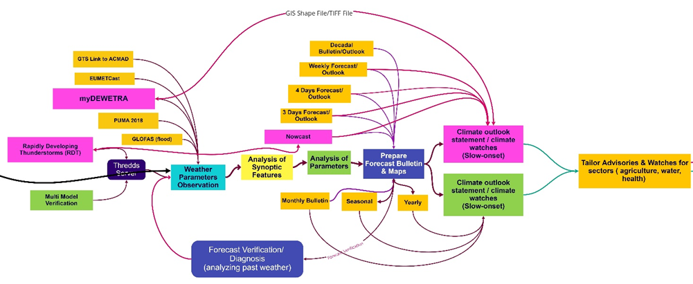
Figure: Multi-hazard advisories and watches development
- Step 1: Data acquisition (Weather parameter observations): Forecasters are expected to have access to and view the myDEWETRA , GloFAS, and other existing nowcasting interfaces under the observation process. For Rapidly Developing weather events, review the RDT interface and interpret the consequences and provide the forecast.
- Step 2: Process and Analysis of the synoptic features: Along with the satellite-based nowcasting, forecasters need to concurrently analyze the synoptic charts of ground stations for current and past weather and examine the previous situation and also anticipate future evolution e.g. convective system is decaying and increasing which needs to consider for the forecasting. Forecasters regularly use PUMA stations for the analysis, now myDEWETRA platform will provided added value for GIS based analysis with other attribute features.
- Step 3: Analysis of all atmospheric Parameters including indices : Forecasters need to the analysis of critical synoptic drivers e.g. ITD ( Inter-Tropical Discontinuity ), analyze the movement of monsoon flux, in case of the West African Monsoon period, the moist air coming from the south and dry air coming for the north, deep convection occurs south of the ITD, wind velocity and direction, CAPE( Convective available potential energy) of the atmosphere, tracking information about the convention, convergence or divergence, Analysis Relative Humidity, ( Wet-bulb potential temperature) and other essential parameters.
- Step 4: Prepare the forecast map: Prepare forecast, watches, advisories, outlooks After analyzing all parameters of the region-specific diverse weather system, the forecaster’s job is to prepare a different range of forecasting products and bulletins of the continent.
- Step 5: Prepare tailored sector advisories and watches the multi-hazard map on extreme weather events with GIS tools :
This step, basically to be handled by the disaster risk management professional for interpretation of weather outlook products and extreme events with GIS software by overlaying multiple variables(geospatial layers) for comprehensive multi-hazard exposure, risk and vulnerabilities, developing special-purpose customized maps for disaster risk management, emergency preparedness, response and rehabilitation mapping for the vulnerable sectors, vulnerable communities and risk management stakeholders on the national and local level.
6.2 Types of Products
- Short-range forecasting ( Rainfall observation of Nowcasting, Daily, Weekly): Short-range Forecasts (12 hours to a few days) e.g. Heavy rainfall, strong winds, Floods, Flash floods, Tropical Cyclones,
- Medium-range Forecasts (a few days to two weeks) –Floods, flash floods, strong winds, tropical Cyclones,
- Extended-range Forecasts (two weeks and beyond) – Multi-hazards forecast and risks map on maps on heavy Rainfall, Strong winds, high temperatures, localized thunderstorm, droughts, and other Severe Weather bulletins
- Extended-range Forecasts (two weeks and beyond) – Multi-hazards forecast and risks map on maps on heavy Rainfall, Strong winds, high temperatures, localized thunderstorm, droughts, and other Severe Weather bulletins
- Extended-range Forecasts (two weeks and beyond) – Droughts and Severe Weather Monthly and Seasonal Forecasts – Droughts
- Monthly and Seasonal Forecasts –Monthly and seasonal forecasts continue to improve, developed Multi-hazards maps occurred, a monthly bulletin on heavy Rainfall, Strong winds, high temperatures, localized thunderstorms, droughts, and other Severe Weather bulletins, Monthly Climate Diagnostic bulletin for Africa (RCC).
- Long-range forecasting: Seasonal precipitation forecast, weather(parameter) anomalies, Seasonal temperature forecast map, African seasonal precipitation average map, Seasonal climate forecast bulletin (RCC), seasonal rainfall, and another parameter variability, customized multi-hazards forecast map for development sectors and other customized map.
- Numerical Weather Prediction (NWP) model outputs (D1, D2, and D3 rain accumulation forecast), ITD positions (D1 up to D3), and other relevant outlooks.
- Monthly and seasonal forecasts continue to improve by using myDEWETRA platform.
- Rapidly Developing Thunderstorm (RDT) and rapid on-set weather events.

Figure 2: Proposed linkages among the WMO Regional Specialized Meteorological Centers
Stronger coordination mechanism amongst the continent level WMO designated Regional Climate Centers required to foster the optimally uses meteorological resources, facilitate weather & climate datasets, information, and knowledge products. ACMAD can play a pivotal role in establishing stronger linkages with those hubs for developing precision level meteorological services viz weather warnings, forecasts, and outlooks.
7.4 Way forward:
There are new satellite system being lunched by EUMETCast with lighting sensor ( 3d generation satellites) and other latest hybrid weather overserving techniques, tools are available for easily deployable. Considering the Africa climate change impacts and impending multi-hazards, MHWEC working on most robust impact based multi-hazard early warnings at the precision level weather forecasting, advisory , bulletin development and other weather and multi-hazard early warning service deliveries;
- With operationalizing multi-hazard emergency situation room with data & information capturing capabilities, data process, and design most customized early warning & risk-informed decision-making products and services, interactively disseminating early warnings information & services.
- Deploy the myDEWETRA platform system that has processibility and customization of multi-hazard risk, vulnerability, and exposure at the highest level to come up with precision level MHEWS , having most advanced hydrometeorological risk and vulnerability analyzing myDEWETRA platform, the system provides the geospatial data for a further level of risk analyzing with other GIS/geospatial software’s ( ArcGIS, QGIS, R, surfer, netCDF, MATLAB, Genstat, etc. )
- Having a strong and actionable level of a coordination mechanism for data exchange among the stakeholders with both-way traffic from AUC (ACMAD/ICPAC ) <> RECs<> Member States <> HMHS<> Government Sector Department <> Local Governments <> Vulnerable Community.
- Establish coordination and linkage with National Media, News outlets, Community Radios for disseminating and having risk information.
- Engagement of national-level HMHS organizations for analyzing extreme weather-induced risk and vulnerabilities, and keep them with AUC-led coordination mechanism.
- Upgradation of ACMAD RCC to impact-based multi-hazard early warnings situation room intended to address the impact-based early warning gaps. The ACMAD situation room remains to be linked with other Situation Room of AUC(EOC), ICPAC, EECs, AU sub-organs, Member States, and beyond.
- Establish coordination and linkage WMO designated centers for having specialized region-focused weather data and information.
For complete documents – Please email at : zmsajjad@gmail.com
This research is strictly being copyrighted by the researcher: Z M Sajjadul Islam , Multi-hazard early warning Expert
For Detailed knowledge, System design, ICT Technologies, Geospatial & IT Programmatic coding and other issues related to Global Multi-hazard early warnings please email : zmsajjad@gmail.com
Call me at WhatsApp : +88 01711 979179 , Skype : zmsajjad