Methodology, Tools, and Guidelines on Impact-Based Forecasting (IBF)
Multi-hazard early warning center (MHEWC)
Designed & implemented by : Z M Sajjadul Islam , UNDP – International Consultant, Mongolia
Acronym
| AI | Artificial Intelligence |
| ALAGaC/ | Administration of Land Affairs, Geodesy and Cartography |
| ALAMGaC | Agency for Land Administration and Management, Geodesy and Cartography |
| AWS | Automatic Weather Station |
| 5W | Who will do what, where, when, and how |
| BTS | Base transceiver station |
| CRVA | climate risk and vulnerability assessment |
| CSV Excel file | comma-separated values |
| CAP | Common Alerting Protocol |
| CBO/CSO | Community-based organization / Community services organizations |
| CMA, | China Meteorological Administration |
| IBFWS | Impact-based Forecast and Warning Services |
| CRVA | Climate Risk and Vulnerability Assessment |
| DIMA | National Rangeland Monitoring Database |
| EM-DAT | Emergency Events Database |
| DCPC | Data Collection and Processing Center |
| DTM/DEM | Digital Terrain Models (DTM)/ Digital Elevation Models (DEM) |
| EAP | early action protocol |
| EOC | Emergency Operations Center |
| FAO | Food and Agriculture Organization |
| AM/FM Radio | Amplitude Modulation/Frequency Modulation |
| FBF | forecast based Financing |
| FTP | File Transfer Protocol |
| FGD | Focus Group Discussion |
| GIS | Geographic Information System |
| GPS | Global Positioning System |
| HCT | Humanitarian Country Team |
| HPC | high processing power computing |
| IBF | impact-based forecasting |
| ICS | Incidence Command System |
| ICT | Information and Communication Technology |
| IFRC | International Federation of Red Cross and Red |
| IM | Information Management |
| IP | Internet Protocol |
| I-NGOs | International /National Non-Governmental Organization |
| IRIMHE | Information and Research Institute of Meteorology, Hydrology, and Environment |
| IVR | Interactive Voice Response |
| JMA, | Japan Meteorological Agency |
| KMA | Korea Meteorological Administration |
| KII | Key Informant Interviews |
| KML/KMZ | Keyhole Markup Language |
| LEMA | Local Emergency Management Agency |
| L & D | Loss and Damage |
| MET | Ministry of Environment and Tourism |
| MIS | Management Information System |
| MHEWS | multi-hazard early warning system |
| MODIS | Moderate Resolution Imaging Spectroradiometer |
| MoED | Ministry of Economy and Development |
| MOU | Memorandum of understanding |
| MoFALI | Ministry of Food, Agriculture and Light Industry |
| MRCS | Mongolian Red Cross Society |
| NAMEM | National Agency Meteorology and the Environmental Monitoring |
| NDVI | Normalized difference vegetation index |
| NEC | National Emergency Commission |
| NEMA | National Emergency Management Agency |
| NMHS | National Meteorological and Hydrological Services |
| NOAA | National Oceanic and Atmospheric Administration |
| ODBC/JDBC | Open Database Connectivity/ Java Database Connectivity |
| PDNA | post-disaster damage, loss and needs assessment |
| NSO | National statistics office |
| PIU | Project Implementation Unit |
| PSTN | Public switched telephone network |
| REST | RESTful Application Programming Interface( API) |
| RIMES | Regional Integrated Early Warning System for Africa and Asia |
| R & D | Research & Development |
| SMS | Short Message/Messaging Service |
| SME | Small and Medium Enterprise |
| SoD | standing orders on disaster |
| TWG | Technical Working Group |
| WCS | Web Coverage Services |
| WMS | Web Map Service |
| WFS | Web Feature Service |
| WPS | Web programming service |
| UHF | Ultra-high frequency |
| UNDP | United Nations Development Programme |
| UNEP | United Nations Environment Programme |
| UNFPA | United Nations Population Fund |
| UNICEF | United Nations International Children’s Emergency Fund |
| VHF | Very high frequency |
| WFP | UN World Food Program |
| WMO | World Meteorological Organization |
Contents
1.0 Chapter : Introduction of Impact-Based Forecasting :
1.1 Importance of developing an integrated IBF platform :
1.2 Framework of integrated impact forecasting, weather warning, and MHEWS.
1.3 The expected benefits of an integrated IBF platform:
2.0 Chapter: Stakeholder Partnership & Communication.
2.1 Rationale of Partnership ( both formal and virtual context) :
2.2 Data Coordination and exchange mechanism..
2.3 Mandating partnership for data coordination, exchange, and risk communication.
2. 4 Technical Working Group for forecast Impact analysis :
2.5 Process of translating traditional forecast/weather outlook to impact forecasts :
2.6 Defined roles of partners during multi-hazard emergencies :
2.7 Partnership capacity building Process :
2.7.1 Organize regular Workshop/Consultation/Seminar/Meetings to improve service delivery:
2.7.2 Removing the Barriers to partnership building :
2.7.4 Improving IBF and warning systems efficiency and Efficacy.
3.0 Chapter: ICT Structures of IBF Platform :
3.1 Implementation of Opensource Geospatial Platform :
3.1.1 Component of Opensource Geospatial Platform:
3.1.2 Installation of Geoserver :
3.1.3 Anchoring google mapping tools :
3.1.4 Installation and Configuring surveying apps.
3.1.5 Deploying File-Sharing Tools :
3.1.6 Implementing Web converting common alerting protocol (CAP )apps :
3.2 Rationale of integrating ICT with the IBF platform :
3.3 Software & Tools Proposed for the ICT-integrated IBF Platform..
3.4.1 Data workflow and data archive structures ( at IBF central level ) :
3.4.2 Centralization of Database Archive and Services by IBF Platform..
3.4.2.1 Develop databases with PostgreSQL server :
3.4.2.2 Impact forecast manufacturing tools, input datasets, and Process:
4.0 Chapter: Data Coordination and exchange mechanisms.
4.1 Data Coordination and exchange mechanisms at Aimag level :
5.0 Chapter : Aimag Emergency Operations Center (EOC) / Situation Room..
5.1 Mandating an Emergency Operations Center (EOC) / Situation Room at the aimag center :
5.2 Aimag level NAMEM human resources :
5.3 Structure of the Aimag EOC / Situation Room..
5.4 Functions of EOC / Situation Room :
5.4.1 Technical Functions of EOC / Situation Room :
6.0 Chapter : IBF Forecasting Process.
6.3 IBF preparation and forecasting process :
6.4 Converting traditional forecast to IBF.
6.4.1 Analyze impacts over the seasonal forecasts :
6.4.2 Processing monthly IBF :
6.4.3 Preparing medium-range Forecast :
6.4.4 Preparing short range Forecast :
6.4.5 The short-range forecasts usability :
6.5 Short range impact forecast preparation.
7.0 Chapter : Operational Forecasts :
8.0 Chapter : The multi-hazard early warning system..
8. 1 Improved and hybrid weather observation mechanism :
8.2. Process of developing an Early Warning :
8.3 The multi-hazard early warning process:
8.4 Anchoring NEMA Early Warning System with IBF:
8.5 Integrated IBF, Warnings, Alerting, and energy hazard early warnings & Advisories :
8.6 Convective weather condition-induced hazards early warning :
8.7 Convective weather condition screening mechanism..
8.8 Strong/Damaging Wind induced hazards warning :
8.9 Hazardous winter weather early warning :
8.10 Template: Winter weather emergency advisory.
8.11 IBF Flood Impact Forecasting:
9.0 Chapter: Impact Forecasting and Warning for Livestock Sector :
9.1 Impact analyzing methodology :
9.2 Risk repository development process :
9.3 Advisory on Integrated Pasture Monitoring System:
9.4 Alert and warning services for livestock & Crop agriculture.
9.5 Develop dzud risk profile :
9.6 Web-based MIS system for Dzud risk management :
9.7 Develop Dzud Early warning protocol.
1.0 Chapter : Introduction of Impact-Based Forecasting :
The impact-based forecasting (IBF) is a technical & operational shift from traditional forecast( ‘what weather be ) to impact forecast (‘what weather can do’). It encompasses transformative and structural changes from the traditional forecasts to IT database & GIS tool-based analytics of color-coded thresholds of impacts, exposure, risks, vulnerabilities of the ground, anticipatory losses & damages likely to impend over the forecast lead time. Therefore, the humanitarian community and vulnerable sectors will early be informed about the impact level and be able to develop an early action protocol (EAP) for better preparedness. ICT-driven integrated impact-based weather forecasting, warning, alerting, and multi-hazard early warning system( MHEWS) is a WMO’s new approach to coming up with a one-stop solution to improved weather and climate information services starting from baseline climate risk and vulnerability assessment, risk repository, and atlas preparation so that any impending hazards weather events being well screened, predicted with spatiotemporal scale and anticipatory loss & damages (L & D) being well advised over the forecast lead-time until hazardous weather events being dissipated.
Traditional weather forecasting provides limited information on weather conditions, such as temperature, precipitation, wind speed, and, other atmospheric conditions, but IBF takes it steps further by providing information on how those conditions could impact ground elements by & large. For example, an IBF forecast intends to provide information on frequency, the intensity of weather events, the threshold of impacts at the spatiotemporal scale of the impending hazardous weather, anticipatory risk and vulnerability, loss & damages(L & D) are likely, how to develop an early action protocol (EAP), early warning based early action ( EWEA) detailed contingency plans and anticipatory budgeting to be allocated for better preparedness, etc.
1.1 Importance of developing an integrated IBF platform :
Addressing the diverse and rapidly changing weather phenomena of Mongolia the IBF system is intended to bridge the structural, process, and forecast product manufacturing gaps of NAMEM/IRIMHE. A robust integrated IBF platform methodology is being proposed for linking and mandating other essential partners to interactively contribute to the system. IBF implementation and operational process intended to reciprocate & correlate impact calculation process of forecasted impending high-impact weather conditions being impacting with existing baseline risks and vulnerabilities of the elements on the ground.
The IBF process depends on the multifaceted, interactive, functional, regular proactive coordination mechanism amongst all stakeholders. The data-sharing protocol to the IBF process. The IBF needs to classify the stakeholder categories, the responsibilities over to risk information coordination, risks and impeding impact interpretation over to impending onset extreme weather events and to managing the risk and vulnerabilities of induced disaster.
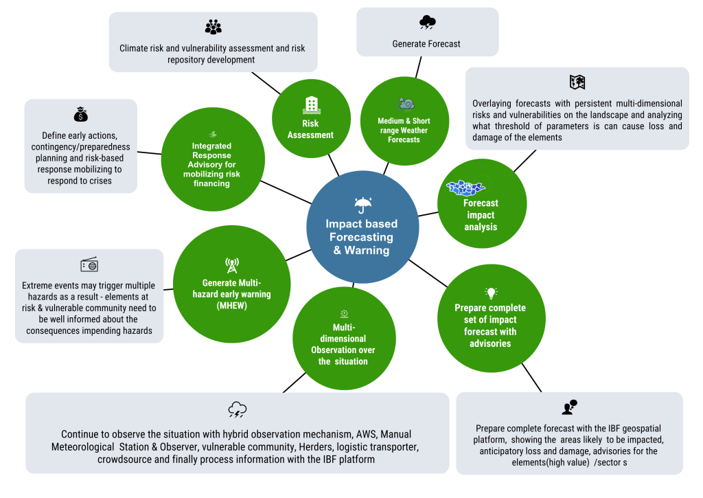
Figure 1: Integrated IBF system overview
- The important input ingredients for the IBF process are to have a readily available sector-specific comprehensive baseline risk and vulnerability assessed repository, corresponding risk and vulnerability attribute database, and risk atlas analysis with GIS tools for forecast impact analysis.
- The ICT-enabled IBF platform has an interface for real-time information tracking of crowdsourcing and ICT-based hybrid surface weather observation ( automated system) on the current hazardous weather conditions,
- Weather and climate risk-informed planning tools for sectoral planning and project/scheme implementation.
- Multi-layered weather forecasts, weather warnings, alerting, impending multi-hazard early warning, hotspot tracked geospatial dashboard with tailormade impending weather and climate information services for holistic sectoral preparedness planning and triggering anticipatory early actions for minimization of L & Ds.
- Develop robust hazard-informed Ealy action protocol (EAP), early warning early actions planning, devising anticipatory loss, and damage scenarios based on pre-emptive humanitarian response planning and contingency mobilization.
- Develop GIS tools-based IBF platform has the provision for analyzing the threshold-based weather warnings and develops common alerting protocol in the event of severe weather expected to trigger disaster. The platform able to provide Multi-hazard Impact-based Forecast and Warning Services and national meteorological and hydrological services (NMHS) agencies be able to directly communicate with vulnerable communities, sectors, and end-users with group-based apps and can provide any useful situational updates for informing common alerting.
- Designing an IBF structured information system on impact forecasting, hazard warning, tailor-made exposure, and vulnerability information to identify risk and support for humanitarian decision-making, provides a way forward to undertake early action that reduces damages and loss of life from natural hazards.
- Traditional weather forecasts indicate what the weather will be, for example, 70 mm & above hourly rain in a given location., however, IBF considers the vulnerability of elements and vulnerable population and their assets to heavy rainfall-triggered flooding and flash flooding impacts, such as loss of life and properties.
- The main benefit of the IBF is that it combines hazard forecasts like heavy rainfall, severe wind, or temperature, with the elements that are exposed to the hazard such as buildings, transport routes, and population distribution, and the vulnerability of individuals, properties, or infrastructure.
- The IBF enables an integrated, authoritative message to be delivered to all parts of society so that everyone can take appropriate action to ensure personal safety and protect property.
1.2 Framework of integrated impact forecasting, weather warning, and MHEWS
The intended design aspect of an integrated IBF is to provide a one-stop solution for weather and climate information services. This robust Mongolian IBF system essentially to complement the WMO’s global efforts of transitioning from traditional weather forecasts to integrated impact forecasting, weather warning, alerting, and multi-hazard early warning system (MHEWS) extensively covering to last mile. The proposed IBF system is also imperative for the Sendai Framework to full-scale Implementation and access of MHEWS and disaster risk information and assessments to the climate frontline.
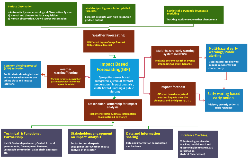
Figure 2: Framework of impact base forecasting, warning, alerting, and MHEWS(Source: Z M Sajjadul Islam).
1.3 The expected benefits of an integrated IBF platform:
- Impact-based forecasts and warnings provide a roadmap of anticipatory actions, an early action protocol(EAP) that enables preparedness measures for saving lives, properties, and livelihoods.
- Impact-based forecasts and warnings communicate information that allows those at risk to make effective decisions to safeguard against the impact of forecast extreme weather or climate events.
- Developing impact-based forecasts and warnings builds strong, collaborative partnerships between national meteorological and hydrological services and sectors operating in disaster risk reduction and management.
- Impact-based forecasting communicates uncertainties. Decision makers can factor the uncertainties into choosing appropriate actions.
- Forecast producers and users of Impact-based forecasting and warnings are able to share data, best practices, and critical information before, during, and after weather and climate events to improve the quality of forecast and warning information. There are opportunities for forecasts to support strategic planning in the County such as through using forecasts to inform sectoral annual plans and related budgets, to raise awareness of potential climate risks, and resource mobilization for early action.
2.0 Chapter: Stakeholder Partnership & Communication
Core objective: The principal objective is to develop a stronger commitment, mandating coherent coordination of partners, and stakeholders by networking to a hybrid partnership mechanism of data/information coordination, exchange, and risk communication mechanisms.
IBF processes the multifaceted functional and proactive coordination mechanism regularly. The data-sharing paradigm is inextricably linked to the IBF process. We need to classify the stakeholder category, and the responsibilities, on the multi-hazard onset, and disaster onset.
State-of-the-art ICT-enabled interface artificial intelligence(AI) and IT program-driven functional systems having robust traceability capacity over the 24/7 proactiveness can predict what weather will do and impacts level, anticipatory intensity and frequency, scalability of extreme weather parameters turning to disaster, and need to be well addressed.
2.1 Rationale of Partnership ( both formal and virtual context) :
The IBF has indispensable features and service delivery capacities for mandating the connectedness of stakeholders with the system and remains operational for demand driven service deliveries. The engineering aspect of the IBF platform to design with ICT enabled robust architecture for having optimum operability with interfacing multiple sources information, recurrent processability, and the IBF product output system optimally works on an interactive partnership of stakeholders across the country. The sector-specific impact level analysis of the hazardous weather parameters sought the involvement of designated specialized government national hydrometeorological organizations (NMHS), sectoral departments, R & D organizations & specialists, academia, mandated partners, commercial stakeholders, herders, and vulnerable community to contribute inputs for making IBF readily available and on the time.
Mandating the aforementioned stakeholders through a set of standard operating procedures (SoP ) viably to a common consensus of a proactive, time-critical partnership and collaboration amongst the wide range of technical partners and agencies engaged in meteorology, climatology, hydrology, disaster risk management, local government sectors, pre-disaster risk assessment group, post-disaster damage, loss and needs assessment (PDNA) group, disaster first-responders, vulnerable community, herders group, etc. for the contribution. The IBF system thus ensures functional partnership by encouraging stakeholders getting into access to the platform with a sense of ownership imperatively to demand-driven weather information service delivery for the IBF related data/information process, informed tools development, and deliverables to climate & disaster emergency management.
The IBF process depends on the multifaceted, interactive, functional, regular proactive coordination mechanism amongst all stakeholders. The data-sharing protocol to the IBF process. The IBF needs to classify the stakeholder categories, the responsibilities over to risk information coordination, risks and impeding impact interpretation over to impending onset extreme weather events and to managing the risk and vulnerabilities of induced disaster.
2.0 Chapter: Stakeholder Partnership & Communication
Core objective: The principal objective is to develop a stronger commitment, mandating coherent coordination of partners, and stakeholders by networking to a hybrid partnership mechanism of data/information coordination, exchange, and risk communication mechanisms.
IBF processes the multifaceted functional and proactive coordination mechanism regularly. The data-sharing paradigm is inextricably linked to the IBF process. We need to classify the stakeholder category, and the responsibilities, on the multi-hazard onset, and disaster onset.
State-of-the-art ICT-enabled interface artificial intelligence(AI) and IT program-driven functional systems having robust traceability capacity over the 24/7 proactiveness can predict what weather will do and impacts level, anticipatory intensity and frequency, scalability of extreme weather parameters turning to disaster, and need to be well addressed.
2.1 Rationale of Partnership ( both formal and virtual context) :
The IBF has indispensable features and service delivery capacities for mandating the connectedness of stakeholders with the system and remains operational for demand-driven service deliveries. The engineering aspect of the IBF platform to design with ICT enabled robust architecture for having optimum operability with interfacing multiple sources of information, recurrent processability, and the IBF product output system optimally works on an interactive partnership of stakeholders across the country. The sector-specific impact level analysis of the hazardous weather parameters sought the involvement of designated specialized government national hydrometeorological organizations (NMHS), sectoral departments, R & D organizations & specialists, academia, mandated partners, commercial stakeholders, herders, and vulnerable community to contribute inputs for making IBF readily available and on the time.
Mandating the aforementioned stakeholders through a set of standard operating procedures (SoP ) viably to a common consensus of a proactive, time-critical partnership and collaboration amongst the wide range of technical partners and agencies engaged in meteorology, climatology, hydrology, disaster risk management, local government sectors, pre-disaster risk assessment group, post-disaster damage, loss and needs assessment (PDNA) group, disaster first-responders, vulnerable community, herders group, etc. for the contribution. The IBF system thus ensures functional partnership by encouraging stakeholders gettin
2.2 Data Coordination and Exchange Mechanism
The initial IBF workflow is to analyze the impacts of impending extreme weather being just forecasted, but the whole IBF mechanism demands multiple layers of information, e.g., requisites of background risk & vulnerability datasets are essential. The IBF process comes across over the steps and primarily to do a background check of the persistent risk and vulnerabilities being inherited from the landscape, local weather & climate system, and inbuilt environmental context, and secondly to estimate the risk, vulnerability, exposure, and sensitivity over the standing elements(annexure 1) at the event of impending extreme /hazardous weather are likely to be interacting with the ground, thirdly, stakeholders need to know how and what level of frequencies of the extreme weather events are turning multi-hazards. Finally, the whole IBF mechanism needs to track hazardous events until they dissipate and take stock of the trail of L & D being yielded by the localized disaster.
Considering the above functional steps, the IBF workflow process ( discussed figure 3, & figure 4 ) is segmented into several workstreams, and at any given stage, stakeholder engagement is very important. The IBF process needs to depend on an input system of data capture, repository, and archives of root-level sectoral and elements risk and vulnerability data for the purpose-driven IBF process. The partners and stakeholders are mandated to supply their climate risk and vulnerability (CRVA) data and information for reviewing the persistent risk and vulnerabilities and push for recurrently updating information to the IBF system.
In any given case of rapidly changing weather( spatiotemporal and hourly/diurnally changed ) patterns e.g., an incidental case of cold fronts induced storm on 26 May 2008 caused a huge amount of damage, and it claimed 52 human tolls and about 600,000 livestock are lost (UNDP 2008). Unlike this type of weather uncertainty and very fastest onset weather conditions are recurrently taking a lot of tolls on livestock. Herders, smallholder farmers, and sector departments need to develop an event repository of high-impacts, loss, and damage scenarios an important baseline archive for analyzing the impacts in further impact analysis.
For analyzing the high-impacts the IBF impact analysts( meteorologist ) team always need to do the background checks (from the impact database) for similar sort of weather events being anticipated and impending as high-impact weather conditions. The partnership process to be mandated by the essential background (risk repository development and understanding) works need to be done by the partners for strengthening the IBF process, as it is such a hybrid process that forecasters, sector/elements risk & vulnerability analysts always need to be well concerted with climate change impacts, climate variables/parameters, weather, impending multi-hazards, spatiotemporal impact interpretation, weather risk and vulnerability assessment and risk prioritizations.
All participating stakeholders/partners/authorities/vulnerable communities are to be mandated to contribute elements specific baseline risk and vulnerability information for the effectiveness and efficiency of the system- IBF partnership mechanism. The partnership mechanism( figure 3 ) renders the both-ways communication e.g., giving the inputs baseline risk, vulnerability geolocation information of every element and harmonizing the risk-informed tools benefiting the sectoral planning process continues even after the development and implementation of impact-based forecasting services. Members of the partnership can be tasked with monitoring the effectiveness of forecasts and warnings and providing feedback for improvement.
Partners have roles important in risk communication and analyzing the impact of forecasts and warnings. Essential partners are to be mandated with responsibilities for early actions to prepare for and respond to hazardous weather and climate events. These actions include advising vulnerable communities on what to do in extreme weather or climate events. Combining partner’s anticipatory advice with impact-base.
2.3 Mandating partnership for data coordination, exchange, and risk communication
Considering the types of workflow and mandating partner’s responsibilities over the interacting and integrating with the IBF platform for weather and Climate risk information communication, sharing data and information repository on sector-specific risk and vulnerability all those are administrative processes. Essentially NEMA & NAMEM jointly play a pivotal role by mandating partners with defined standard operating procedures ( SOP) in information coordination and communication mechanisms from the local to the central level.
- The sector department is to be mandated to conduct Climate and weather risk and vulnerability and risk repository. For harmonizing external data from the partners/ Stakeholder/sector departments, several tools have been proposed e.g. google drive, dorpbox, Microsoft SharePoint(useful) , IBF FTP server, IBF geonode server, and from crowdsource to use Kobo-toolbox, SurveyMonkey, WhatsApp, Twitter, Facebook, Telegram, mobile apps, etc., all those tools for instantly capturing any event situation, circulated news, social journalism, for capturing pictures, video clips on situation updates on multi-hazards, disaster incidence from the field level for alerting and situational update about the on-going hazardous events at the frontline.
- Conducting climate and weather risk and vulnerability assessment (CRVA) and risk repository development: Sector department e.g. Livestock & crop agriculture, water, soil & land department, Municipality/urban local governments, ( aimag, soum, bag), communication and transport sector, industries & mining sector, private sector ( value chain operators ), etc., organization and entities to be mandated to conduct CRVA for their sector, share risk information with IBF platform and contribute for the forecast impact analysis and event situation reporting.
- Weather and climate information services: Autonomously NAMEM/IRIMHE is being mandated for generating weather forecasts, weather warnings, alerting, surface weather observation, and climate information services to supply as input devices for impact-based forecasting and forecast-based financing process.
- Multi-hazard risk information collection, hazardous situation, and disaster incidence tracking: The National Emergency Management Agency (NEMA) & Local Emergency Management Agency (LEMA) is the nodal agency of Mongolia to play the leading role and mandate the local government actors, local humanitarian actors, MRCS volunteers for dealing with the multi-hazards. Mandating Local Government Sector departments, community volunteers, herders, and sector field technicians to capture weather risk phenomena e.g., impending thunderstorm/lighting/heavy rainfall, strong wind, dust storm/haze, cold rain, snowstorm onset, extreme cold & high temperature, winter storm, high-density snowfall, etc. data with geolocation(lat./long.), picture and video. Similarly, to capture ongoing multi-hazard and disaster incidence information( pictures, video clips), loss and damage information onset of hazardous conditions. INGO/UN Agency project offices at the local level can play a coordination role in fostering the process.
- Weather factored Dzud risk information tracking and analysis: The Technical Working Group (TWG) to coordinate the Livestock, and crop Agriculture sector to mandate for conducting CRVA, risk repository development, and analyzing impacts of extreme weather on the sector, sectoral elements ( annexure 1) as a specialist sector partner; following special responsibilities also need to be carried out.
- Acquisition of datasets of the biomass pasture conditions over the seasons with data collection from the Rangeland health monitoring station, biomass pasture monitoring through the photo points, available pasture biomass plants, grass over the boreal ecosystem, commercial pasture/forage cropper and yield data, etc.
- Repository (maintains event register/diary) on herder indigenous knowledge and coping capacity of livelihood and livestock to the severe & extreme weather conditions, climate tolerant Livestock husbandry management, weather/climate risk/vulnerabilities on livestock value chain operations, etc, for impact analysis.
- Sustainable pasture management information system: Regular stock-taking, pasture budgeting ( surplus & shortage ), biomass pasture productivity monitoring, ecological health monitoring, Integrated farm management (IFM) practices, DTM management, etc., how risk logging of how weather and climate causing detrimental factors and affecting this value chain management.
- Constantly monitoring and logging risks of the weather and climate change-induced impact indicators over the whole sectoral value chain operations. This is essential for defining the dzud indices for both the climatic and non-climatic indexes/indices and tracking how indicators are contributing to combined dzud factors.
- Jointly set collaboration between the Land Administration department( ALAGaC/ALAMGaC) and the agrometeorological research division to conduct rangeland health monitoring ( 1516 sites data tracking and photographing from photo point monitoring sites ) system, biomass growth monitoring, vegetation types and coverage, soil thawing/degradation, soil health, soil temperature, soil moisture, ice thickness over the soil, snow density, individual dzud factor on pasture grazing barriers( impenetrable ice), drought monitoring(agricultural Hydrometeorological, environmental) needs to contribute data on weekly basis and share GIS maps with IBF platform for pasture/ forage related risk analysis.
- Conduct a survey ( Kobo Toolbox, GPS data logger, GPS essential ) and digitally track the herder’s socio-economic condition, livestock size, livelihood assets of herders, HIES statistical datasets the sector, age-sex disaggregated vulnerability data of the herder household population, livestock age/class data (calf, young, matured ), livestock health/body-condition/weight data (required for dzud risk analysis).
- Record keeping on rapid onset convective weather conditions (thunderstorm, heavy rainfall, lightning, hailstorm) from each herder to send via Kobo-toolbox apps, WhatsApp group, social media to aimag EOC/Situation room/IBF central server via IBF portal converting IBF mobile apps for risk and impact analysis.
- Data and Information coordination with the IBF platform :
Partner-level CRVA database/information management (with Annexure – 3 & discussed next chapter): Input indicators and variables for livestock impact analysis ) to be linked and uploaded to the IBF database server which is an important input for the IBF impact & risk analysis process.
- Archive Sector elements database and risk & vulnerability information repository, multi-hazard risk information, disaster impact, loss, and damage database.
- Mandating Stakeholders working areas ( 5W – Who will do what, where, when, and how), service deliveries, beneficiaries, vulnerable populations, utilization of risk-informed tools in the sectoral development planning process.
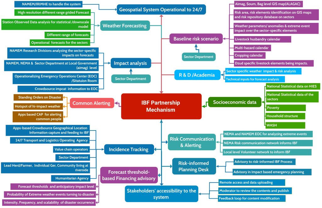
Figure 3: IBF Data coordination, exchange, and partnership mechanism ( Source : Z M Sajjadul Islam)
Table 1: Partner’s Checklist and major role in the IBF Process
| Partner | Technical actors | Major Role |
| IBF Technical Working Group (TWG) | TWG for livestock sector impact (risk and vulnerability analyses ) | Impact forecast preparation for the livestock sector |
| TWG for Dzud risk analysis and Dzud early warning, Dzud alerting | Impact forecast preparation for the Dzud early warning | |
| TWG for Agriculture sector( crop agriculture) impact (risk and vulnerability analyses ) | Impact forecast preparation for the livestock-agriculture sector( crop agriculture) sector | |
| TWG for Soil and Land sector impact (risk and vulnerability analyses ) | Impact forecast preparation for the Soil and Land sector | |
| TWG for the water/hydrological sector | Impact forecast preparation for the environmental sector | |
| TWG for environmental sector impact (risk and vulnerability analyses ) | Impact forecast preparation for the priority sector | |
| TWG for Weather data acquisition( from multiple sources ( station Observation data, AWS, crowdsource source) data analysis | Weather data acquisition from hybrid sources ( figure 9) | |
| TWG for rapidly developing weather conditions monitoring, warning, and common alerting protocol | Impact forecast- warning and common alerting protocol | |
| TWG for data communication | Impact forecast preparation for the priority sector | |
| TWG for Geospatial server and service development | Geospatial server and service development | |
| TWG for database development, data coordination, and exchange | Database development, data coordination, and exchange | |
| Technical Partners | MoFALI /Livestock Department and other research wings, veterinary serviceAdministration of Land Affairs, Geodesy and Cartography(ALAGAC) Sector departments Social WelfareNational Registration and Statistical OfficeMRCSForest Research and Development CentreNational University of MongoliaMongolian University of Science and TechnologyMongolian University of Life SciencesInstitute of Geography and Geo-ecologyRiver Basin Authority Drought Watch-MongoliaMinistry of HealthMinistry of Education and Science of MongoliaEnergy resource company | Spatial risk and vulnerability database, information GIS Map |
| Aimag Government, Sector Departments | State Administration Department. Legal Department. Production, Trade, Agriculture and Environmental Department. Financial and Economic Policy Department. Social Policy Department. Environmental and Agricultural ( livestock and crop agriculture) Head of Governor’s Office. Social Development Officer (education, health care).Agriculture and Environmental Officer. Social Care Officer (Poverty reduction, employment, and social care). Operations Officer.BPO- Border Protection Organization | Conduct Climate Risk and vulnerability assessment, forecast impact analysis, work with incidence command system, operationalize Emergency Operations Center (EOC) or Situation Room |
| Government Sector Ministry / Departments | CSoG-Cabinet Secretariat of the Government MoF- Ministry of Finance FRC-Financial Regulatory Commission of Mongolia IPTTA- Information, Post, Telecommunications and Technology Authority, MAS- Mongolian Academy of Science MASM-Mongolian Agency for Standardization and Metrology MECS- Ministry of Education, Culture, and Science MoFALI – Ministry of Food, Agriculture and Light Industry MoET- Ministry of Environment and Tourism MSPL- Ministry of Social Protection and Labor NEMA- National Emergency Management Agency MoFA- Ministry of Foreign Affairs | Conduct Climate Risk and vulnerability assessment, forecast impact analysis, work with incidence command system, operationalize Emergency Operations Center (EOC) or Situation Room |
| Partnership with WMO regional hubs | Regional Forum( JMA, CMA, KMA) DCPC Beijing / Hong Kong Regional Integrated Early Warning System for Africa and Asia (RIMES) | Regional climate model, outlook sharing |
| CBO/CSO | Community-based organization Community services organizations Private Sector Entity, Value chain operatorsLogistic transporter Multilateral Organization, National Committee, Working Group | Conduct a survey and provide Climate Risk and vulnerability data, risk information communication with EOC or Situation Room |
| Humanitarian Country Team | 11 UN clusters in Mongolia e.g Early Recovery, Education, ETC, Food Security, Health, Logistics, Nutrition, Protection, Shelter, and WASHHumanitarian Country Team ( UNDP, FAO, WFP, IFRC, WHO, WMO, UNHCR, ) Humanitarian actor ( MRCS, NEMA volunteers) UNICEF Risk Communication and community engagement (RCCE) | Climate Risk and vulnerability data, risk information communication with EOC or Situation Room |
| NEMA | National Emergency Commission/NEC National Center for Communicable Diseases/NCCD, National Center for Public Health/NPHC etc.Institute of Astronomy and Geophysics (IAG) Emergency Operations and Warning Center of the National Emergency Management Agency (EOWC)National Center for Emergency and Disaster Relief (NCEDR) | Operationalizing Incidence Command System (ICS) during emergencies and linking with aimag EOC or Situation Room The military serves as first responders for earthquakes, wildfires, forest fires, contagious diseases, snow and dust storms, and severe winters.Sharing Climate risk and vulnerability information. Forecast impact analysis with aimag EOC or Situation Room. |
| NEMA | State Reserves UnitsFirefighting and Rescue UnitsRescue Units and TeamsEmergency ManagementDivisions of DistrictsRescue UnitsFirefighting and Rescue UnitsDDR Training CenterSupply, Logistics, and Services UnitRetraining and Rehabilitation Center Building №3Fuel Reserve Unit Food Reserve Unit | Activities on search and rescue unit, rescue and firefighting unit, and state reserve unit in Tuvshuruuleh soum. 68 personnel. support of local police agencies and local governors’ offices.National Police Agency (NPA) and General Authority for Border ProtectionEmergency services by 9,000 active-duty troopsNational Incident Management System’s Incident Command System (ICS) platform. In 2004, Mongolia adopted ICS as the primary guide.Public Emergency service ( Earthquake, Fire Forest fire, First aid, Acute infectious diseases, Snow and dust storms. Dzud dangers, Flood and water hazards) |
| National Media & Broadcasting network | Mongolian National Public Radio (AM/FM) and TVMongolian TV Broadcasters AssociationNational Radio Community radioNational electronic mediaNational Optical fiber network, PSTN operator • Government Media and Public Relations Department (Cabinet Secretariat) • Public Council under the IAAC • National Emergency Commission (NEC), NEMA, UB Health Authority, National Center for Public Health, National Center for Communicable Diseases • Media and Information Council • Press Institute Mongolian Websites AssociationMongolian Newspapers Association | Dissemination of emergency weather warning Organize live Radio/TV shows on weather emergencies and interactive sessions with vulnerable communities for getting situation updates. Impact forecasts dissemination to the target audiences Incorporate media monitor updates, pictures, and videos into the IBF platform. |
| Crowdsource | Herders (Basecamp) Aimag CenterSoum CenterBag CenterFarmers (lead) Logistic transporterTourism operators, hotels, motels, restaurants Commercial installations ( SME/Enterprises/Shops)Educational institutes Gasoline/Petrol pumpsHealthcare centers, local governments departments Volunteers (MRCS/LEMA/NEMA/Community)Vulnerable communities living at climate frontline ( riverside, lower floodplain, etc.) Value chain operatorsAviatorsTransporters Social media operatorsOpen Street Collaborative mapping | Event reporting/situation reporting of multi-hazards. Weather condition monitoring and updating to EOC/IBF platform.Sharing local-level multi-hazard risks and vulnerabilitiesProvide risk information to Incidence Command System (ICS) during emergencies and link with aimag EOC or Situation Room Sharing Climate Risk and vulnerability information |
| Telecommunications network | Cell phone operators National telecom authorityNational electronic mediaNational Optical fiber network, PSTN operator | Utilizing cell phone tower ( BTS) for setting up AWS( weather monitoring instrument ) Being mandated by the government – provide free SMS, Interactive Voice Response (IVR), Cell Broadcasting, and Toll-free calling for dedicated cell phones ( frontline vulnerable community ( herders/farmers/community/rescuer/emergency response team/ logistics transport/volunteers) for facilitating emergency data /risk communication and Supporting livestock department in tracking herders’ GPS location by using free internet data services for a few designated times.Support for emergency risk communication and dissemination. |
| Social network | Social network operatorsCrowdsource communication group- Facebook, WhatsApp, Telegram, Viber, CallPro Mongolia Collaborative mapping Qfield of OpenStreetMap, Open layer, survey 123, Online survey /data collection apps: Kobo Toolbox, survey monkey etc | Social media – i.e., information sharing through platforms. Crowdsensing – i.e., citizens on the Web or equipped with smartphones using dedicated applications to register and share observations (e.g., citizen observatories); Collaborative mapping – using Qfield apps of OpenStreetMap, the Open layer creates internet-based interactive maps (e.g., OpenStreetMap). |
2. 4 Technical Working Group for forecast Impact analysis :
For facilitating the IBF process, technical working groups ( TWG) and designated responsibilities need to be mainstreamed for setting out a cross-functional IBF working modality. The table below outlined the workflows of TWGs.
Table 2: Technical Working Group for the IBF Impact Analysis
| Technical working group for the IBF process | Partnering organizations | Member/Department | Responsibilities of the Technical Working Group (TWG) for contributing IBF process | Requirement of ICT tools/Interface /IBF Platform |
| TWG for livestock sector impact (risk and vulnerability analyses ) analysis | Forecasting Division (IRIMHE/NAMEM) | ForecastersSynoptic EngineersData archive team | Develop forecast CSV files, forecast briefings, impact threshold area delineation, analyze impact thresholds with GIS software for the country as a whole, and aimag/soum level CSV/Shapefile for the local level impact forecast.Upload to Geonode Server for other groups and users to interpret and utilize | Access to Geonode server and upload datasets/files and create a map of the forecasts and forecast briefings. Access to SharePoint Server and upload filesAccess to FTP File server |
| TWG for livestock sector impact (risk and vulnerability analyses ) analysis | Operational forecast team for the livestock sector (IRIMHE/NAMEM) | ForecastersSynoptic EngineersAgrometeorology expertsRangeland health monitoring expertsForage crop production Cooperative society Data archive team | Operational forecast team to analyze weather impacts ( hi-impact weather ) on the livestock( types) over the next 7-10 days (weekly/decadal) and what types of impacts are being triggered by anomalies, and extreme parameters of seasons. Advisory on adverse effects of weather | |
| TWG for livestock sector impact (risk and vulnerability analyses ) analysis | MoFALI /Livestock Department and other research wings, veterinary service | Livestock Department Veterinary department Breeding department | Sector department offices at the local level open the forecast by logging in to Geonode server, then open the map and provide each parameter-specific impact ( Snowstorm/Winter Strom, heat wave, cold rain, thunderstorm, flood/landslide/mudslide ) likely to cause of sickness, death, starvation, disease, weight loss, etc.Briefing about livestock adaptive management coping with adverse weather being forecastedDevelop a livestock management calendar | Upload all datasets to the IBF PostgreSQL server /MSSQL server. |
| TWG for livestock sector impact (risk and vulnerability analyses ) analysis | Agrometeorological division(IRIMHE/NAMEM) | Agrometeorological division | Engaged jointly with the operational forecast team. Traditional livestock husbandry is affected by natural hazards very often and has experienced significant impact.Collect fodder/forage biomass conditions data every weekly interval from 1516 representative sample collection points. Develop a livestock husbandry calendar.Develop a calendar on livestock grazing days with open biomass.Collect soil moisture, and soil temperature data in week intervals.Collect ice/snow thickness from the 1516 representative sample collection points. Collect soil thawing data from the local level.Collect multi-hazard impacts on livestock and agriculture. Create WhatsApp groups of all field-level technicians (members of the 1516 team, soil-related data collectors, and field surveyors) | Prepare all attribute/layers datasets (geocoordinate lat./long, parameter readings, attribute data ) and upload to SharePoint Server and other servers necessarily |
| TWG for livestock sector impact (risk and vulnerability analyses ) analysis | NEMA | LEMA at aimag level (LEMA) | NEMA/LEMA to provide emergency information management services and risk and vulnerability assessment. Multi-hazard risk, vulnerability, and exposure database Past Disaster event map (area of extent where it occurred ) Past Disaster Hotspot (GPS location / Placemark) Map a) Where disaster occurred? b) Death tolls, injured, affected, displaced? :Multi-hazard risk atlas (National, Aimag Level) Aimag-wise GIS Base maps showing infrastructures (buildings, institutes, physical structures, socio-economic structures, dzud response trigger point, emergency shelters for livestock and population, marketplace, location of NEMA office building, Hospital, health care center, emergency relief storage facilities, commercial installation, ) Sample of contingency plan for national level, Aimag, and Bag level | Using ArcGIS/QGIS and logging in to IBF geospatial platform for developing GIS map and information services |
| TWG for livestock sector impact (risk and vulnerability analyses ) analysis | The Administration of Land Affairs, Geodesy, and Cartography (ALAGAC) | Urban developmentLand ManagementGeodesy and Cartography (Geospatial Services) | ALAGAC/ALaMGAC to provide GIS shapefile and access to https://geoportal.nsdi.gov.mn enable REST API WCS, WFS, WPS services and provide GIS shapefiles at Geonode/GeoServer for elements risk and vulnerability analysis. Access to IBF geospatial platform, download weather forecast CSV files, and analyze risk and vulnerabilities of impending extreme weather over to elements of urban land management system. During normal times conduct an assessment of the climate/multi-hazard risk and vulnerabilities to urban/rural built-in infrastructures /structures /installations, urban critical infrastructures, and utility service structures for risk repository development.Database on the elements of urban infrastructures and basic services, settlements, high-value elements, and essential unity services ( power Plant, Power distribution point, hot water supply network, power supply network, gas supply network ) Provide anticipatory advisory on the high impact to urban, settlements, land use, industry, enterprise, urban services deliveries, and other elements narrated above | Using ArcGIS/QGIS and logging in to IBF geospatial platform for developing GIS map and information services |
| TWG for livestock sector impact (risk and vulnerability analyses ) analysis | Aimag/Soum/Bag level agriculture and livestock department | Agricultural office Livestock office | Conduct CRVA assessment on herder’s camp, pastureland, permanent and seasonal grazing areas, and forage crop areas prepare database and geolocation ( lat./long.) on number & types of livestock, transport, and vehicle, livelihood assets, economic conditions, the communication device ( android cell, Radio, TV, wireless, forecast radio, season wise camp geolocation, etc. Prepare a calendar on the multi-hazards impactful to livestock.Prepare Livestock husbandry daily event calendar.Prepare Fodder crisis days on the calendar.Prepare calendar supplement feeding days purchased from insurance. Prepare calendar supplement feeding days purchased with your own money.inventorying of animal death recordsDaily inventorying of the impactful weather conditions for the livestock ( 24/7 ). Daily inventorying of animal diseases, outbreaks Inventorying geolocation, preparing cartographic maps, showing biomass pasture growing areas, identifying the areas where forage cropping is possible, identifying where natural water resources are available for irrigation Maintain all log sheets/registers mentioned in Annexure 4 | Using ArcGIS/QGIS and logging in to IBF geospatial platform for developing GIS map and information services |
| TWG for livestock sector impact (risk and vulnerability analyses ) analysis | Remote sensing division (IRIMHE/NAMEM) | Agrometeorological divisionClimate Change division.Environmental Information Center | Maps on Vegetation coverage ( every 10 days)Maps on Snow coverage, density, the thickness of snow, thickness of icing over the groundPrepare vegetation coverage maps ( MODIS satellite image) Maps on agriculture, meteorological and hydrological drought Maps on environmental protection areas, reserve land/forest, Agricultural land, and land cover map. | Using ArcGIS/QGIS software and logging in to IBF geospatial platform for developing GIS map and information services |
| TWG for livestock sector impact (risk and vulnerability analyses ) analysis | Environmental information divisions (IRIMHE/NAMEM) | Agrometeorological divisionClimate Change division. Environmental Information Center | Analysis of high-impact weather and calculate impacts. | Using ArcGIS/QGIS and logging in to IBF geospatial platform for developing GIS map and information services |
| TWG for livestock sector impact (risk and vulnerability analyses ) analysis | MRCS ( Mongolian Recross Society) | Community VolunteerHumanitarian Volunteers | Anchoring MRCS/IFRC dzud risk management tools to the IBF platform Linking MRCS emergency preparedness and response management network with IBF risk communication network and platform Support service by MRCS volunteers’ access to the country and linking with the IBF risk communication network to contribute to emergencies, events taking place, tolls, loss and damage scenarios, and incidence records (geolocation, pictures, video and incidence placemark and technical briefings) | Using ArcGIS/QGIS and logging in to IBF geospatial platform for developing GIS map and information services |
| TWG for livestock sector impact (risk and vulnerability analyses ) analysis | FAO | FAO country project office/ field Unit/volunteer/stakeholder | Anchoring Early Warning Early Action (EWEA) with IBF Platform to address dzud early warning and early action, FbF Anchoring FAO Anticipatory Action (AA) or Forecast-based Financing (FbF) to IBF Conduct Dzud risk assessment in the socio-economic conditions of herders and incorporate it into IBF.Conduct livestock risk and vulnerabilities to impeding extreme weather conditions and high impacts and support the IBF team for interpreting impacts of hi-impact weather on livestock. FAO volunteers to support the IBF team about the sensitivity, risk, exposure, and vulnerability situations of extreme weather events. Weather risk and vulnerabilities over livestock management. | Using ArcGIS/QGIS and logging in to IBF geospatial platform for developing GIS map and information services |
| TWG for livestock sector impact (risk and vulnerability analyses ) analysis | HCT ( Humanitarian Country Team) | UN Agency project offices at Aimag level | Anchoring with IBF and FBF platforms for informing humanitarian coordination and response decision-making mechanism.Anchoring functional linkage with IBF & FBF and providing contributions for IBF & FBF functionaries. Support services analyzing extreme weather impacts to Climate vulnerable sectors (livestock and agriculture), support for Climate and extreme weather impact warnings. Climate and weather impacts on (i) animal breeding, feeding, health conditions, husbandry practices, (ii) pasture management, (iii) manure management, (iv) plant production, protection, and health, (v) soil health and fertility, and (vi) public health.Provide information on national e-agriculture strategy and pilot selected ICT solutions for enhanced monitoring and management of food systems. | Using ArcGIS/QGIS and logging in to IBF geospatial platform for developing GIS map and information services |
| TWG for livestock sector impact (risk and vulnerability analyses ) analysis | NSO ( National Statistical Organization) | Aimag/Soum level | Anchoring NSO datasets over the ODBC (Opens source database connectivity ) for accessing NSO socio-economic vulnerability, HIES data, and sector-specific databases ( updated) | Using ArcGIS/QGIS and looking at IBF geospatial platform for developing GIS map and information services |
| TWG for livestock sector impact (risk and vulnerability analyses ) analysis | WFP | Project office at Central & Aimag/Soum level | Anchoring WFP emergency management network with IBF & FBF Support IBF for livestock risk management | Using ArcGIS/QGIS and logging in to IBF geospatial platform for developing GIS map and information services |
| TWG for livestock sector impact (risk and vulnerability analyses ) analysis | UNDP | Project office at Central & Aimag/Soum level | Provide relevant data/information exchange and coordination support for assessing extreme weather impacts over the livestock sector and analyzing weather impacts. | Using ArcGIS/QGIS and logging on with IBF geospatial platform for developing GIS map and information services Using IBF WhatsApp, telegram, Facebook group |
| TWG for livestock sector impact (risk and vulnerability analyses ) analysis | Livestock value chain operator | Country level | Provide information and data on any risk and vulnerabilities being created by the impending extreme weather-induced multi-hazards and impacts on the Livestock value chain operations.Track record of impending multi-hazards impacts over livestock value chain operations ( storing, input supply, processing ).Network with the IBF platform and exchange information (geolocation) on extreme weather situations, risks, livestock tolls, loss, and damage of the sectors | Using IBF WhatsApp, telegram, Facebook group |
| TWG for livestock sector impact (risk and vulnerability analyses ) analysis | Livestock feed processing industries | Country level | Provide information and data on livestock output supply-oriented food processing industries (milk, meat, cashmere, lather ) do experience impacts of extreme weather conductions.Keep a track record of impending multi-hazard impacts over food processing value chain operations (storing, input supply, processing ).Network with the IBF platform and exchange information (geolocation) on extreme weather situations, risks, livestock tolls, loss, and damage of the processing cycle. | Using IBF WhatsApp, telegram, Facebook group |
| TWG for livestock sector impact (risk and vulnerability analyses ) analysis | Commercial Forage crop cultivators | Smallholder farmersCommercial agro-farm Pasture/forage crop production/supply groupLivestock herder group Pasture management and utilization group Rangeland health monitoring group Local government Agriculture department Livestock department | Provide climate risk and vulnerability data on crop agriculture, weather impacts over the forage cultivation cycle.Provide a multi-hazard calendar irrespective of types for forage crop productions. Provide information on selected perennial forages, including oats and alfalfa. The second phase of the project focuses more on capacity building, growing maize for silage, and other fodder conservation methodologies. | Using IBF WhatsApp, telegram, Facebook group |
| TWG for Dzud risk analysis and Dzud early warning, Dzud alerting | IRIMHE/NAMEM | Forecasting DivisionNWPRemote sensing research div.Climate change research div.Environmental research div | Always remain connected with TWGs, provide forecast CSV files and briefings, and update emergency weather warning /alert services ahead of impending events Data acquisition, calibration, assimilation, the process of surface weather observation data, and uploading to PostgreSQL server, FTP server, etc.Develop algorithms on nowcasting services, emergency operational forecasts on rapidly developing weather conditions, running statistical and Dynamical downscale models on the real-time, time-series weather data.Running automated Linux cronjobs/running scripts to operationalize emergency weather forecast/outlook/updates/watch form real-time gathered data from hybrid observation system( figure 9), prepare instant weather map ( automated process),Prepare automated common alerting protocol( CAP), and weather warning with IBF geospatial tools, services, API, and programs.Develop an algorithm for running Statistical /Dynamical model analysis on live observation data to show the live weather phenomena with nowcasting, generate warnings, prevailing weather conditions, and live incidence plotting with warning maps. Regularly review extreme weather parameters, impending impact intensity, lead-time to be impending, prepare different types of demand drive forecasts ( daily/operational, point-based, high-value element based ) impact analysis and develop anticipatory loss and damage scenarios and eventually issue impact warning (color-coded)for the sector. Prepare multi-hazard incidence maps from the crowdsource data, process and reflect multi-hazard incidence, the severe situation at the ground, prevailing severity, and continuity of ongoing weather conditions over a bad weather system.Review observation outlook provides advisories over the trend. Acquisition of livestock-sensitive weather indicators datasets from weather station( temp, precipitation, wind speed/direction, RH, cold front, convective weather conditions, dust/haze storm, snowstorm, etc.) parameters. | Hybrid observation tools, crowdsource observation( figure 9)Customized and readily usable forecast software Forecast CSV file & weather briefing, Statistical and Dynamical weather modeling software for processing station data Realtime data capture, data calibration, and assimilation software Data repository to PostgreSQL serverAccessing geonode & geoserver IBF Internal /External geospatial services ArcGIS / QGIS software with data-capturing apps from field-level volunteers Placing IP webcam at the high raised ground for the monitoring the high-value elements( urban centers ) for landscape observation, open-eye observations of cloud conditions/convective conditions |
| TWG for Dzud risk analysis and Dzud early warning, Dzud alerting | LEMA at aimag/soum/bag level | Emergency response team Humanitarian & Emergency volunteers | Support IBF with energy situational information, hazard incidence report, and conduct an immediate needs assessment of livestock during emergency onset. Networking of all humanitarian actors/volunteers at the local level and mandating them to provide information to the IBF platform.Dissemination of emergency warnings through the NEMA network | Using IBF WhatsApp, telegram, Facebook groupIBF surveying Kobo Toolbox apps, hotspot mapping apps (IBF Platform) , GPS logger /GPS essential apps |
| TWG for Dzud risk analysis and Dzud early warning, Dzud alerting | IRIMHE/NAMEM | Synoptic Engineer with NAMEM aimag /soum level (Table 4: Aiamg Team ) Operational forecast team for the livestock sector (IRIMHE/NAMEM) | Constant review of the weather forecast cycle and review of the parameters are sensitive and impactful to livestock lifecycle based on the growing season.Provide warnings and advisories on high-impact weather being forecasted and anticipatory impacts over the livestock lifecycle. | Forecast software, Statistical and Dynamical weather modeling software for processing station data Data calibration and assimilation software Accessing to PostgreSQL serverAccessing geonode & geoserver IBF geospatial services ArcGIS / QGIS software |
| TWG for Dzud risk analysis and Dzud early warning, Dzud alerting | MoFALI | MoFALI /Livestock Department and other research wings, veterinary service | Livestock database and geolocation of every camp to provide the point base weather forecasts for the livestock, pasture conditions in every season, pasture shortage time, animal diseases, animal breeding, veterinary services for weather-related diseases, forage crop production, and fodder biomass degradation areas.Register/log sheet on high weather extreme parameters/conditions impacting livestock herding. Fodder biomass area identification on map and fodder biomass condition Temperature impacts on the calf, tender animals. Storage of hay/fodder for animals, without drinking water, animals are treating snow, Sudden onset weather events – Cold rain, convective thunderstorms, High winds/dust storm-related disease. | Using IBF WhatsApp, telegram, Facebook groupIBF surveying Kobo Toolbox apps, hotspot mapping apps (IBF Platform) , GPS logger /GPS essential appsAccessing to PostgreSQL serverAccessing geonode & geoserver IBF geospatial services ArcGIS / QGIS software |
| TWG for Dzud risk analysis and Dzud early warning, Dzud alerting | IRIMHE/NAMEM | Agrometeorological divisionRemote sensing research division.Climate change research division.Environmental research divisionForecasting & NWP Division Aimag LEMA/NAMEM | Every 10 days forage/pasture status, soil moisture condition, soil icing, soil health conditions, soil thawing incidence, desertification warning, forage crisis warning. Rangeland’s health condition every 10 days(times series )Biomass pasture condition every 10 days(times series )Drought/flash drought conditions every 10 days(times series )DroughtWatch Mongolia every 10 days(times series )Pasture degradation map (times series )Drinking water access point (times series )Livestock drinking water points and conditions ( season-specific) Herders level pasture stock/destocking condition updates every 10 days(times series )Maps on agricultural cropping areas in every season (times series )Forage crop maps on every season (times series )Nomadic ger location and hard size( number of livestock) | Accessing to PostgreSQL serverAccessing geonode & geoserver IBF geospatial services REST API, WCS, WMS, WFS with ArcGIS and QGIS Pasture soil moisture EM50DataTrack 3ECH20 Utility software DIMA Software, Photo point monitoring softwareSoftware Paste user group management. Software Ecological site group managementSTM model |
| TWG for Dzud risk analysis and Dzud early warning, Dzud alerting | ALAGAC/ALAMGaC | The Administration of Land Affairs, Geodesy, and Cartography (ALAGAC) | ALAGAC local offices to maintain track records of multi-hazard incidence are taking place at the local level.Track record of basic infrastructures and services being impacted by extreme weather events e.g., transport, logistics, emergency service trigger points, storage facilities, market infrastructures, and basic services.Keep track records on weather impacts over the designated pasture lands, pastureland management, maintain user group, operational and management of pastureland. Analyze with GIS tools how many infrastructures/structures and elements are likely to be impacted by the impending hazardous weather events. Analyze the loss and damage of the elements being impacted by the hazardous weather. | REST API, WCS, WMS, WFS with ArcGIS and QGIS Accessing to PostgreSQL serverAccessing geonode & geoserver |
| TWG for Dzud risk analysis and Dzud early warning, Dzud alerting | Local Government | Aimag/Soum/Bag level sector department | Track record of high-impact weather events induced any incidence taking place at any herds level, track record of forage demand and availability during disaster onset.Provide voluntary information on any incidence | Accessing to PostgreSQL serverREST API, WCS, WMS, WFS with ArcGIS and QGIS Accessing to PostgreSQL serverAccessing geonode & geoserver |
| TWG for Dzud risk analysis and Dzud early warning, Dzud alerting | IRIMHE/NAMEM | Remote sensing research division | Forest fire incidence Snowfall coverage, snow thickness map, and datasets Drought incidence with spatiotemporal level data to IBF | REST API , WCS, WMS, WFS with ArcGIS and QGIS Accessing to PostgreSQL serverAccessing geonode & geoserver |
| TWG for Dzud risk analysis and Dzud early warning, Dzud alerting | IRIMHE/NAMEM | Environmental information divisions Agrometeorological division Agrometeorological research divisionRemote sensing research divisionClimate change research division.Mongolian Drought watch teamALAGACFAODrought Watch Mongolia | Support IBF for analyzing the impacts of the environmental, agricultural, soil, and land sectors by processing the following tools.; Vegetation coverage map /information of every 10 days mapDrought condition map of every 10 days map Drought mapDzud ( snow Cover) map Wildfire incidence of 1-24 hrs incidence tracking Vegetation coverage for pasture forecasting Pasture Anomaly mapPasture Biomass mapPasture Trend mapSnow cover maps ( using MODIS terra-aqua ) map with 250m resolution with an average thickness of snow ( cm) and average density of snow ( g/cm cubic) from the station data. The map is useful for monitoring agriculture, livestock, transport, livelihood sectors, and dzud analysis. Taking support from the global domain on forest fire hotspot monitoring (web. )Fire Information for Resource Management System (FIRMS) with Landsat, VIIRS( S-NPP, NOAA 20, MODIS ( Aqua, Terra) Fire incidence of 1-24 hrsWorld Forest Fire Watch web-based on the thermal anomaly ( day & night ) acquired by MODIS aqua image on fore and a thermal anomalyVegetation outlook on every 10 days map by using MODIS ( aqua) satellite image.Vegetation changes in % of values of multi-year average NDVI index subtracting by NDVI with 10 days average and representing with maps with maximum increase green color and max decrease in red color. A drought outlook map produces every 10 Days interval for supporting environmental monitoring. | REST API , WCS, WMS, WFS with ArcGIS and QGIS Accessing to PostgreSQL serverAccessing geonode & geoserver |
| TWG for Dzud risk analysis and Dzud early warning, Dzud alerting | Mongolian Recross Society | MRCS aimag level setup | Emergencies induced by high-impact wearer conditions and incidence information | REST API , WCS, WMS, WFS with ArcGIS and QGIS Using IBF WhatsApp, telegram, Facebook groupIBF surveying Kobo Toolbox apps, hotspot mapping apps (IBF Platform) , GPS logger /GPS essential apps |
| TWG for Dzud risk analysis and Dzud early warning, Dzud alerting | FAO at the country level | FAO Dzud early warning system | Anchoring FAO early warning to IBF and issuing any weather emergency in the livestock sectors | REST API , WCS, WMS, WFS with ArcGIS and QGIS Using IBF WhatsApp, telegram, Facebook groupIBF surveying Kobo Toolbox apps, hotspot mapping apps (IBF Platform) , GPS logger /GPS essential apps |
| TWG for Dzud risk analysis and Dzud early warning, Dzud alerting | Humanitarian Country Team | HCT ( Humanitarian Country Team) | REST API , WCS, WMS, WFS with ArcGIS and QGIS Using IBF WhatsApp , telegram, Facebook groupIBF surveying Kobo Toolbox apps, hotspot mapping apps (IBF Platform) , GPS logger /GPS essential apps | |
| TWG for Dzud risk analysis and Dzud early warning, Dzud alerting | NSO | NSO ( National Statistical Organization) at the country and local level | Vulnerable herders and the number of livelihoods | IBF surveying Kobo Toolbox apps, hotspot mapping apps (IBF Platform) , GPS logger /GPS essential apps |
| TWG for Dzud risk analysis and Dzud early warning, Dzud alerting | WFP | WFP project offices | Anchoring WFP early warning system | REST API , WCS, WMS, WFS with ArcGIS and QGIS Using IBF WhatsApp , telegram, Facebook groupIBF surveying Kobo Toolbox apps, hotspot mapping apps (IBF Platform) , GPS logger /GPS essential apps |
| TWG for Dzud risk analysis and Dzud early warning, Dzud alerting | UNDP | UNDP project offices | Contribution by the field level experts to IBF early warning | REST API , WCS, WMS, WFS with ArcGIS and QGIS Using IBF WhatsApp , telegram, Facebook groupIBF surveying Kobo Toolbox apps, hotspot mapping apps (IBF Platform) , GPS logger /GPS essential apps |
| TWG for Dzud risk analysis and Dzud early warning, Dzud alerting | Private sector (Promoter ) | Livestock value chain operator | Provide information on any hazardous event over the Livestock value chain with geolocation | Using IBF WhatsApp , telegram, Facebook groupIBF surveying Kobo Toolbox apps, hotspot mapping apps (IBF Platform) , GPS logger /GPS essential apps |
| TWG for Dzud risk analysis and Dzud early warning, Dzud alerting | Promoter/SME | Livestock-related food processing industries | Provide information on any hazardous event in the food processing industries with geolocation | Using IBF WhatsApp , telegram, Facebook groupIBF surveying Kobo Toolbox apps, hotspot mapping apps (IBF Platform) , GPS logger /GPS essential apps |
| TWG for Dzud risk analysis and Dzud early warning, Dzud alerting | Private sector (Promoter ) | Commercial Forage crop cultivators | Provide information on any hazardous event over the Livestock value chain with geolocation | Using IBF WhatsApp , telegram, Facebook groupIBF surveying Kobo Toolbox apps, hotspot mapping apps (IBF Platform) , GPS logger /GPS essential apps. |
| TWG for Agriculture sector( crop agriculture) impact (risk and vulnerability analyses ) | IRIMHE/NAMEM | Agrometeorological research divisionRemote sensing research divisionClimate change research division | By using an Operational forecast for agriculture – prepare risks and vulneraries of the sector; Crop calendarHazard calendarClimate norms mapClimate anomaly MapHistorical anomaly track record of the seasonCorps planning decision-making based on Agroclimatic threshold based / severity. Calculate risk over crop cycle 0-90, 0-120 days.Determine the weather parameters that are likely to impact agriculture cropping in every growing season. Pasture and rangeland health monitoring every 10 days and mapping. | Operational forecast team for the livestock sector Statistical and Dynamical weather modeling software for processing station data Data calibration and assimilation software Accessing to PostgreSQL serverAccessing geonode & geo server IBF geospatial services ArcGIS / QGIS software IP web cam |
| TWG for Soil and Land sector impact (risk and vulnerability analyses ) | IRIMHE/NAMEM | Agrometeorological research divisionRemote sensing research divisionClimate change research division.Mongolian Drought watch teamALAGAC | Prepare forecast for soil and land sector Using soil data from the station prepare soil sector climate risk map. Soil thawing map Soil temperature and moisture map Agroecology map | Accessing to PostgreSQL serverAccessing geonode & geo server IBF geospatial services REST API , WCS, WMS, WFS with ArcGIS and QGIS Pasture soil moisture EM50DataTrack 3ECH20 Utility software DIMA software , Photo point monitoring softwareSoftware Paste user group management. Software Ecological site group managementSTM model |
| TWG for Soil and Land sector impact (risk and vulnerability analyses ) | The Administration of Land Affairs, Geodesy, and Cartography | The Administration of Land Affairs, Geodesy, and Cartography (ALAGAC) | Land cover map and soil /land classification map | REST API , WCS, WMS, WFS with ArcGIS and QGIS Using IBF WhatsApp , telegram, Facebook groupIBF surveying Kobo Toolbox apps, hotspot mapping apps (IBF Platform) , GPS logger /GPS essential apps. |
| TWG for Soil and Land sector impact (risk and vulnerability) analyses | Local Government at aimag/soum/bag level | Aimag/Soum/Bag level sector department | Soil degradation, Desertification maps | REST API , WCS, WMS, WFS with ArcGIS and QGIS Using IBF WhatsApp , telegram, Facebook groupIBF surveying Kobo Toolbox apps, hotspot mapping apps (IBF Platform) , GPS logger /GPS essential apps. |
| TWG for Soil and Land sector impact (risk and vulnerability) analyses | Remote sensing division Environmental information divisions | Prepare drought map, vegetation cover map Extreme weather impacts on environment and plant species | REST API , WCS, WMS, WFS with ArcGIS and QGIS Using IBF WhatsApp , telegram, Facebook groupIBF surveying Kobo Toolbox apps, hotspot mapping apps (IBF Platform) , GPS logger /GPS essential apps. | |
| TWG for the water/hydrological sector (risk and vulnerability) analyses | The hydrological research division of IRIMHE/NAMEM | Hydrological research divisionForecasting and NWP divisionRiver Basin Authority Remote sensing division Environmental information divisions | Impact analyses of hydrologic hazards flood, flash floods, landslide, mudslides, debris falls, water pollution, etc | REST API , WCS, WMS, WFS with ArcGIS and QGIS DTM/DEM modeling toolsFlood Modelling toolsDrainage basin management tools Using IBF WhatsApp , telegram, Facebook groupIBF surveying Kobo Toolbox apps, hotspot mapping apps (IBF Platform) , GPS logger /GPS essential apps |
| TWG for environmental sector impact (risk and vulnerability analyses ) | NAMEMALAGACMET | Environmental information center Agrometeorological division Agrometeorological research divisionRemote sensing research divisionClimate change research division.Mongolian Drought watch teamALAGACFAODrought Watch Mongolia | Support IBF for analyzing the impacts of the environmental, agricultural, soil, and land sectors by processing and preparing the following tools ; Vegetation coverage map /information of every 10 days mapDrought condition map of every 10 days map Drought mapDzud ( snow Cover) map Wildfire incidence of 1-24 hrs incidence tracking Vegetation coverage for pasture forecasting Vegetation coverage for pasture forecastingPasture Anomaly mapPasture Biomass mapPasture Trend mapSnow cover maps ( using MODIS terra-aqua ) map with 250m resolution with an average thickness of snow ( cm) and average density of snow ( g/cm cubic) from the station data. The map is useful for monitoring agriculture, livestock, transport, livelihood sectors, and dzud analysis. Taking support from the global domain on forest fire hotspot monitoring (web. )Fire Information for Resource Management System (FIRMS) with Landsat, VIIRS( S-NPP, NOAA 20, MODIS ( Aqua, Terra) Fire incidence of 1-24 hrsWorld Forest Fire Watch web-based on the thermal anomaly ( day & night ) acquired by MODIS aqua image on fore and a thermal anomalyVegetation outlook on every 10 days map by using MODIS ( aqua) satellite image.Vegetation changes in % of values of multi-year average NDVI index subtracting by NDVI with 10 days average and representing with maps with maximum increase green color and max decrease in red color. A drought outlook map produces every 10 Days interval for supporting environmental monitoring. | Accessing to PostgreSQL serverAccessing geonode & geo server IBF geospatial services REST API , WCS, WMS, WFS with ArcGIS and QGIS Pasture soil moisture EM50 softwareDataTrack 3ECH20 Utility software DIMA Software, Photo point monitoring softwareSoftware Paste user group management. Software Ecological site group managementSTM model |
| TWG for Weather data acquisition( from multiple sources ( station Observation data, AWS, crowdsource source) data analysis | NAMEM at the local level NEMA emergency communication team | Climate change research division. Weather forecasting division | Improve observation capacity of exiting the manual met station. Set up Automatic weather stations to monitor high-value elements Improve flood and flash flood warning system. Develop crowdsource data communication open-source maps, google clouds, open source geonode server-based open layer, GPS logger, GPS Essential and other surveys, event capture, and placemark capturing tool on impending and ongoing multi-hazard events. NEMA emergency communication team | REST API , WCS, WMS, WFS with ArcGIS and QGIS Using IBF WhatsApp, telegram, Facebook groupIBF surveying Kobo Toolbox apps, hotspot mapping apps (IBF Platform) , GPS logger /GPS essential appsIBF Apps for hotspot data capture |
| TWG for rapidly developing weather conditions warning and common alerting protocol | NAMEM | NAMEM at HQ ( IBF Platform)NEMA at HQ LEMA/NEMA at aimag level | Using Google’s public alerting system, CAP system alerting the hazardous impending events can potentially do loss and damage | REST API , WCS, WMS, WFS with ArcGIS and QGIS Using IBF groups on WhatsApp, Viber, Telegram, Facebook group/page, national AM radio, TVIBF live web telecasts using customized tools /social network.IBF surveying Kobo Toolbox apps, hotspot mapping apps (IBF Platform), GPS logger /GPS essential appsIBF Apps for hotspot data capture |
| Emergency weather warning | NEMA | LEMA, NAMEM at aimag, soum level | NEMA/LEMA to provide emergency information management services and risk and vulnerability assessment. Multi-hazard risk, vulnerability, and exposure database Past Disaster event map ( area of extent where it occurred ) Past Disaster Hotspot ( Placemark ) Map a) Where disaster occurred? b) How many people died, were injured, affected, or displaced? :Multi-hazard risk atlas ( National, Aimag Level) Aimag-wise GIS Base maps showing infrastructures (buildings, institutes, physical structures, socio-economic structures, dzud response trigger points, emergency shelters for livestock and population, marketplace, location of NEMA office building, Hospital, health care center, emergency relief storage facilities, commercial installation, ) Sample of contingency plan for national level, Aimag, and Bag level, | Using IBF groups on WhatsApp, Viber, Telegram, Facebook group/page, national AM radio, TVIBF live web telecasts using customized tools /social network.Access with IBF geospatial geonode server with REST API, WCS, WMS, WFS with ArcGIS and QGIS Uses of IBF WhatsApp, telegram, Facebook group/pageIBF surveying Kobo Toolbox apps, hotspot mapping apps (IBF Platform), GPS logger /GPS essential appsIBF Apps for hotspot data capture |
| Emergency weather data collection and transmission to IBF | Herders FarmersLogistic transporterTourism operators, hotels, motels, restaurants Commercial installationsPetrol pumpsHealthcare centers, local governments departments Volunteers (MRCS/LEMA/NEMA)Aimag CenterSoum CenterBag Center | MRCS/NEMA/LEMA/NAMEM and Local government to maintain, and organize the functional group | Mandating Local herders provide real-time weather conditions ( current wind speed, temperature, cloud conditions, precipitation conditionsMandating responsible authority/group to of aimag/soum/bag to provide real-time weather conditions ( current wind speed, temperature, cloud conditions, precipitation conditionsMandating Logistic transporter, Logistic transporter, Tourism operators, hotels, motels, restaurants, Commercial installations, Petrol pumps, Healthcare centers, local governments departments, volunteers (MRCS/LEMA/NEMA), individuals/responsible persons of the locality, and Volunteers bag to provide real-time weather conditions ( current wind speed, temperature, cloud conditions, precipitation conditions during the onset of extreme weather events already impacting and damaging over the elements. | Using IBF groups on WhatsApp, Viber, Telegram, Facebook group/page, national AM radio, TVIBF live web telecasts using customized tools /social network.IBF surveying Kobo Toolbox apps, hotspot mapping apps (IBF Platform), GPS logger /GPS essential appsIBF Apps for hotspot data capture Connectged with Aimag EOCConnected with national radio serviceConnected with Facebook live serviceConnected with National TV serviceConnected with IBF web TV/Web Radio service. Connected with WhatsApp user group, and Facebook page for live broadcasting |
| MRCS | MRCS/NEMA/LEMA/NAMEM and Local government to maintain and organize the functional group and mandate primary data collection. | Anchoring MRCS/IFRC dzud risk management tools to the IBF platform Linking MRCS emergency preparedness and response management network with IBF risk communication network and platform Support service by MRCS volunteers’ access to the country and linking with the IBF risk communication network to contribute to emergencies, events taking place, tolls, loss and damage scenarios, and incidence records ( geolocation, pictures, video, and incidence placemark and technical briefings ) | REST API , WCS, WMS, WFS with ArcGIS and QGIS Using IBF WhatsApp, telegram, Facebook groupIBF surveying Kobo Toolbox apps, hotspot mapping apps (IBF Platform) , GPS logger /GPS essential appsIBF Apps for hotspot data capture | |
| FAO | FAO/MRCS/NEMA/LEMA/NAMEM and Local government to maintain, and organize the functional group | Anchoring Early Warning Early Action (EWEA) for to IBF Platform to address dzud Anchoring FAO Anticipatory Action (AA) or Forecast-based Financing (FbF) to IBF Conduct Dzud risk assessment in the socio-economic conditions of herders and incorporate it into IBF.Conduct livestock risk and vulnerabilities to impeding extreme weather conditions and high impacts and support the IBF team for interpreting impacts of hi-impact weather on livestock. FAO volunteers to support the IBF team about the sensitivity, risk, exposure, and vulnerability situations of extreme weather events. Weather risk and vulnerabilities over to livestock management, | REST API , WCS, WMS, WFS with ArcGIS and QGIS Using IBF WhatsApp, telegram, Facebook groupIBF surveying Kobo Toolbox apps, hotspot mapping apps (IBF Platform) , GPS logger /GPS essential appsIBF Apps for hotspot data capture | |
| WFP | WFP/MRCS/NEMA/LEMA/NAMEM and Local government to maintain, and organize the functional group | Emergency fodder early warning system livestock and Emergency food early warning system herder’s household | REST API , WCS, WMS, WFS with ArcGIS and QGIS Using IBF WhatsApp, telegram, Facebook groupIBF surveying Kobo Toolbox apps, hotspot mapping apps (IBF Platform) , GPS logger /GPS essential appsIBF Apps for hotspot data capture | |
| Land Administration | Local Offices | Incidence of any flooding, flash flooding, mudslide, debris fall, or avalanches information to IBF platform | REST API , WCS, WMS, WFS with ArcGIS and QGIS Using IBF WhatsApp, telegram, Facebook groupIBF surveying Kobo Toolbox apps, hotspot mapping apps (IBF Platform) , GPS logger /GPS essential appsIBF Apps for hotspot data capture | |
| Aimag government | Sector department officesLocal Administration Pasture Management Group | Emergency fodder management, allocation of reserves fodder for the herders, incentives for forage crop cultivation, shelter | REST API , WCS, WMS, WFS with ArcGIS and QGIS Using IBF WhatsApp, telegram, Facebook groupIBF surveying Kobo Toolbox apps, hotspot mapping apps (IBF Platform) , GPS logger /GPS essential appsIBF Apps for hotspot data capture | |
| TWG for data communication | NAMEM | NAMEM at HQ ( IBF Platform) Department of Meteorological Communication and Information Division NEMA at HQ LEMA/NEMA at aimag level EOC/Situation room | Communicate with partners and collect sector specific Climate risk and vulnerability data of the local level sector and elements. Multi-hazard incidence data from the local level communication with Crowdsource networking and data analysis | Configure PostgreSQL as the data source for data synchronization uploading the CSV, Excel file.GIS shapefile |
| NEMA | Local NEMA and LEMA office, technical unit, communication hub, Installation | NEMA/LEMA to provide emergency information management services and risk and vulnerability assessment. Multi-hazard risk, vulnerability, and exposure database Past Disaster event map ( area of extent where it occurred ) Past Disaster Hotspot ( Placemark ) Map a) Where disaster occurred? b) How many people died, were injured, affected, or displaced? :Multi-hazard risk atlas ( National, Aimag Level) Aimag-wise GIS Base maps showing infrastructures (buildings, institutes, physical structures, socio-economic structures, dzud response trigger point, emergency shelters for livestock and population, marketplace, location of NEMA office building, Hospital, health care center, emergency relief storage facilities, commercial installation, ) Sample of contingency plan for national level, Aimag, and Bag level | REST API , WCS, WMS, WFS with ArcGIS and QGIS Using IBF WhatsApp, telegram, Facebook groupIBF surveying Kobo Toolbox apps, hotspot mapping apps (IBF Platform) , GPS logger /GPS essential appsIBF Apps for hotspot data capture | |
| MRCS | Local MRCS coordination Offices Volunteers | Anchoring MRCS/IFRC dzud risk management tools to IBF platform Linking MRCS emergency preparedness and response management network with IBF risk communication network and platform Support service by MRCS volunteers’ access to the country and linking with the IBF risk communication network to contribute to emergency situations, events are taking place, tolls, loss and damage scenario and incidence records ( geolocation, pictures, video and incidence placemark and technical briefings ) | REST API , WCS, WMS, WFS with ArcGIS and QGIS Using IBF WhatsApp , telegram, Facebook groupIBF surveying Kobo Toolbox apps, hotspot mapping apps (IBF Platform) , GPS logger /GPS essential appsIBF Apps for hotspot data capture | |
| FAO | Local Project Offices | Anchoring Early Warning Early Action (EWEA) for to IBF Platform to address dzud Anchoring FAO Anticipatory Action (AA) or Forecast-based Financing (FbF) to IBF Conduct Dzud risk assessment in the socio-economic conditions of herders and incorporate it into IBF.Conduct livestock risk and vulnerabilities to impending extreme weather conditions and high impacts and support IBF team for interpreting impacts of hi-impact weather on livestock. FAO volunteers to support IBF team about the sensitivity, risk, exposure, and vulnerability situations of extreme weather events. Weather risk and vulnerabilities over to livestock management, | REST API , WCS, WMS, WFS with ArcGIS and QGIS Using IBF WhatsApp , telegram, Facebook groupIBF surveying Kobo Toolbox apps, hotspot mapping apps (IBF Platform) , GPS logger /GPS essential appsIBF Apps for hotspot data capture | |
| WFP | Local Project Offices | Emergency fodder early warning system livestock and Emergency food early warning system herder’s household | REST API , WCS, WMS, WFS with ArcGIS and QGIS Using IBF WhatsApp , telegram, Facebook groupIBF surveying Kobo Toolbox apps, hotspot mapping apps (IBF Platform) , GPS logger /GPS essential appsIBF Apps for hotspot data capture | |
| Land Administration | Local level offices | Incidence of any flooding, flash flooding, mudslide, debris fall, or avalanches information to IBF platform | REST API , WCS, WMS, WFS with ArcGIS and QGIS Using IBF WhatsApp , telegram, Facebook groupIBF surveying Kobo Toolbox apps, hotspot mapping apps (IBF Platform) , GPS logger /GPS essential appsIBF Apps for hotspot data capture | |
| Aimag government | Local level offices | Emergency fodder management, allocation of reserves fodder for the herders, incentives for forage crop cultivation, shelter | REST API , WCS, WMS, WFS with ArcGIS and QGIS Using IBF WhatsApp , telegram, Facebook groupIBF surveying Kobo Toolbox apps, hotspot mapping apps (IBF Platform) , GPS logger /GPS essential appsIBF Apps for hotspot data capture | |
| MoFALI /Livestock Department and other research wings, veterinary service | MoFALI | Livestock Department and other research wings, | Track record of every extreme weather-related impact on livestock sectors | REST API , WCS, WMS, WFS with ArcGIS and QGIS Using IBF WhatsApp , telegram, Facebook groupIBF surveying Kobo Toolbox apps, hotspot mapping apps (IBF Platform) , GPS logger /GPS essential appsIBF Apps for hotspot data capture |
2.5 Process of translating traditional forecast/weather outlook to impact forecasts :
NAMEM/IRIMHE been entitled as a principal partner to prepare forecasts (e.g. lang range outlooks, anomalies monthly, seasonal, yearly) relating to regional, and global weather/climate factors affecting technical analysis of trend, screening weather/Climate risk and vulnerability from the trends.
| Types emergency functions | Prioritized activities (Traditional Forecast preparation ) | Data sources need to be archived | Responsible divisions | Input data for IBF forecasting |
| Weekly/Decadal outlook | Prepare complete outlook with designated template/formats to bring the narrations of the outlook using GIS analytics. Prepare Technical briefings of forecast verification – what has been forecasted, anomaly predicted, and concurrently compared with climatic norms and station observed data with spatiotemporal discussion. | Model outputs to 5km grid resolution CSV files, map Downscale model output | Forecasting Divisions NWP | Systemically archive CSV and shape file of weekly forecast/outlook so that in any given case of forecast investigation those resources can easily be accessed from geonode server and SharePoint server. |
| Monthly outlook | Acquisitions of weather parameters from the global domain ( precipitation, temperature, and wind) for the production of monthly outputs.Conduct multi-model ensembles and model output to higher resolution ( currently 27km grid resolution.Prepare complete monthly analysis of anomalies, weather trends, spatiotemporal resolution, and complete illustrations of designated outlook format.Technical briefings of forecast verification – what has been forecasted, anomaly predicted and concurrently compared with climatic norms and station observed data with spatiotemporal discussion.Each parameter-specific separate analysis | Model outputs to 5km grid resolution CSV files, map Downscale model output | NWP Long-range forecasting division | Systemically archive CSV and shape file of weekly forecast/outlook so that in any given case of forecast investigation those resources can easily be accessed from geonode server and SharePoint server. |
| Seasonal outlook | Conduct multi-model ensembles and model output to higher resolution ( currently 30km grid resolution.Prepare complete monthly analysis of anomalies, weather trends, spatiotemporal resolution, and complete illustrations of designated outlook format.Technical briefings of forecast verification – what has been forecasted, anomaly predicted and concurrently compared with climatic norms and station observed data with spatiotemporal discussion.Each parameter-specific separate analysis | Model outputs to 5km grid resolution CSV files, map Downscale model output | NWP Long-range forecasting division | Systemically archive CSV and shape file of weekly forecast/outlook so that in any given case of forecast investigation those resources can easily be accessed from geonode server and SharePoint server. |
| Yearly outlook | Illustrate yearly atlas of weather anomalies, illustration of the climatology of the country. Analysis of yearly weather and climatological trends in comparison with climatic norms Technical profile and comparative analysis of whole climatology, anomalies of Mongolia.Illustrate areas/sectors/elements being largely impacted by the type of anomalies. | Model outputs to 5km grid resolution CSV files, map Downscale model output | NWP Long-range forecasting division | Systemically archive CSV and shape file of weekly forecast/outlook so that in any given case of forecast investigation those resources can easily be accessed from geonode server and SharePoint server. |
| Climatology of the season and yearly |
Utilizing forecast model data, surface observation time-series data, crowdsource observation data, and preparing weather warnings:
| Types emergency functions | Responsible divisions | Prioritized activities |
| Operational forecasts for high-value elements ( the hazards ) | TWG | Operational Forecast impact analysis |
| Nowcasting and Weather Alerts | TWG | Develop programming scripts e.g., python, java scripts and develop wireframes on multi-hazards, weather alerts |
| Prepare weather warning /multi-hazard early warning | TWG | Develop Forecast impact analysis |
| Conduct Research and analysis on impending multi-hazards that potentially can trigger disasters | TWG | Develop statistical and Dynamical models for providing multi-hazard early warnings |
| Sector-specific operational forecasting | TWG | Forecast impact analysis |
2.6 Defined roles of partners during multi-hazard emergencies :
| Partner | Department/ Division/Wing | Functional role | Coordination role | Data Collection & Exchange | IBF Process |
| NAMEM | Forecast Division | The forecasting division’s operational mundi would be like operationalizing air traffic control over the 24/7 mode to prepare forecasts.Constantly monitoring forecast parameters, synoptic conditions, and overall weather conditions over the lead-time forecasting duration/cycle.Forecast verification – Any given case of weather anomalies is much higher, fluctuating, and transforming to hazardous phenomena -then reflect the current situation with hourly, daily forecasts. Prepare operational forecasts for high-value elements (socio-economic sectors, communication, critical service delivery, urban, mining & industries, etc.) Prepare point-based forecasts. | Provide Technical support services to the sector-specific forecast impact analyzing team. | Develop and upload CSV, Shapefile of the high-resolution forecasts ( at least 5 km grid resolution) Technical cooperation and coordination with NEMA, MRCS, HCT agencies at aimag level, I-NGOs, and all other partners participating with IB. Collect information on hazardous hazard incidence, any losses, and damages.Technical cooperation and coordination with sector departments for the acquisition of sector elements-wise multi-hazard risk and vulnerable data contribute to the IBF platform at regular intervals.NEMA and NAMEM forecasting division to establish communication protocol with all relevant partners during weather emergencies being declared. | Remain connected with IBF and functional to the following. Remain alerted about the updates are providing the risk communication network on impending and ongoing weather hazardous events. Constant monitoring of weather observation network( stations) Constant monitoring of ground-level eye-observed situations with pictures, video clips, and weather parameters manually recorded. Constant monitoring crowdsources provided pictures, video clips, hotspots tracked by mapping apps, location /placemark tracker apps ( kml, kmz other formats), geolocations etc., and incorporating information to categorized IBF warning and alerting tools. Establish emergency conference calls(audio/video) with EOC/Situation room at aimag level, met observers, NEMA emergency teams, NEMA volunteers, MRCS volunteers, sector volunteers, remote herders, lead farmers, emergency logistic operators, HCT aimag level agencies, I-NGOs, and other coordinating partners during emergencies. |
| NAMEM | Long-range forecasting divisions/ Numerical Weather Forecasting Division and | Prepare high-resolution monthly and seasonal forecasts with aimage level CSV file, technical briefing on the country as a whole, weather/climate region, aimag wise and uploading to IBF platform and sending to aimag EOC/Situation room. In coordination with Forecasting, NWP, and Long-range forecasting divisions – prepare operational forecasts on high-value elements( lovelock value chain, agricultural value chain) , installations( communication works) , structures ( mine, industries, power plants, heating system etc) | Forecast briefing, threshold settings, risk interpretations, and communicating with IBF platform. Provide Technical support services to the sector-specific forecast impact analyzing team. Provide Technical support to aimag EOC/ Situation room for developing aimag resolution Impact forecasts for the sectors/elements | Develop and upload CSV, Shapefile of the high-resolution forecasts ( at least 5 km grid resolution) | Constant monitoring of ground-level eye-observed situations with pictures, video clips, and weather parameters manually recorded. Constant monitoring crowdsources provided pictures, video clips, hotspots tracked by mapping apps, location /placemark tracker apps ( kml, kmz other formats), geolocations etc. and incorporating information to categorized IBF warning and alerting tools. |
| NAMEM | Hydrological research division | Download CSV, GIS shapefile from forecast link of IBF geonode/GeoServerData acquisition from hydrological monitoring stations, river gauging stations, runoff gauging stations, permafrost monitoring stations, and flood level monitoring stations.Search from IBF risk communication interfaces, crowdsource repository, met station manually overserved datasets, volunteers provided data/information on ongoing flooding situations, event location, impact level loss, and damage scenarios. Analyze forecasted precipitation thresholds(red, orange, yellow ), intensity and frequency, and time-series accumulated rainfall amount from the ground observations. Analyze the impact level of the forecasts with the elements that are likely to be impacting(quantitively), location, and elements that are likely to be falling under red-covered thresholds, orange zone, and yellow zone.Remain alert for any convective weather conditions are developed, monitor Doppler radar ( UB ), connective clouds from satellite images, signals are throwing from AWS, and manual, human-driven observations from the ground. Remain alert for issuing any convective rain-induced flash flood, river floods, landslide, or mudslide warning and provide technical briefings to the IBF platform on impending hydrological hazards and disasters. | Interactive technical coordination with local-level partners for monitoring and maintenance of all hydrological monitoring stations. Provide relevant GIS shapefile on river basin, catchment areas, current locations of hydrological monitoring/gauging stations, and river network, and propose GIS locations over the river, lake, spring, and drainage networks those points need to be monitored by crowdsource observers(vulnerable community residing over the riverbank, flood-prone areas and other potential volunteers mentioned above. Coordination and communication with ground-level met stations, hydrological stations, and crowdsource observers for fostering constant data/information communications | Develop and upload CSV, GIS shapefile | Establishment and mobilizing crowdsource-based hybrid monitoring ( figure 9) mechanisms that would be responsible for sending hydrological data, e.g. river runoff level, flood level information, flash flooding situations, areas, and elements that are inundated, flooded, landslide, mudslide, avalanche, infrastructure collapse, water logging, loss and damage pictures, information, etc. Remain well interacted with aimag level EOC/Situation room for providing technical supports for GIS mapping of hydrological/water sector risk and vulnerability assessment. |
| NAMEM | Agrometeorological research division | Develop & update time-series agrometeorological database, develop CSV , GIS shapefiles of all observations being conducted by Agrometeorological field level technicians ( biomass conditions, soil thawing, soil dryness, soil moisture, soil water holding capacity, living plant species, natural pasture growing areas, forage /pasture cropping areas, agricultural drought-prone areas, meteorological drought-prone areas, hydrological, drought-prone areas, irrigation access cultivable areas, cropping maps. Data logging ( weekly ) of weather factors that affect agriculture, types of crops, and over the planting seasons, crop-specific and season-specific weather parameters those impact corps and develop GIS map. Develop GIS analytical maps on every observed dataset on bag/soum/aimag level and upload them to the IBF platform. Develop agroecology zone map, soil map, land cover map, and agriculture/cultivable area map on bag/soum/aimag level and upload to IBF platform. Upload /Provide CSV, GIS shapefiles of all 1516 rangeland health monitoring stations, pasture monitoring points, soil moisture measuring station, soil thawing, ground icing conditions, and agrometeorological stations logged data. Conduct GIS analyses of bag/soum/aimag level on up-to-date pasture conditions on the ground, Collect datasets on soil ice data, and pasture conditions /biomass data( % covered by ice, % are still grazable, % decayed ) every week by engaging 1516 rangeland health monitoring stations and developing CSV files, and GIS shapefile for impact analysis. CSV and GIS shape files on herder-specific fodder storage and demand conditions, Herder specific animals drinking water crises. | Recurrent communication with bag, soum, aimag level monitoring technician/experts, sector volunteers, livestock department, agriculture department, ALAGAC, herders, lead farmer, smallholder commercial farmers, and commercial forage producers for regular interval data collection and processing. Prepare impact forecast on livestock sectors, agricultural sector, land, and soil sector and upload to IBF geonode server. Prepare weekly dzud situation updates/dzud operational forecasts and upload them to the IBF geonode server. By analyzing all dzud contributing weather and land observations-based indicators, indices, ground level weekly motoring datasets – develop a dzud risk situation update map and upload it to IBF geonode server. Prepare every type of dzud map of the falling seasons and upload it to the IBF geonode server. Prepare dzud warning maps and situation reports by calculating the aggregated and combined indices to a large extent dzud. and upload to the IBF geonode server | Develop and upload CSV , GIS shapefile | |
| NAMEM | Environmental information Center | Technical support and leading the IBF teams for the ICT support, and IBF platform information management. Analyze the extreme weather impacts on the environment, agriculture, soil, and land sectors by analyzing the EIC-developed 18 databases. | Provide technical support for IBF functional process | Develop CSV, shape file, and upload to the IBF platform | |
| NAMEM | Remote sensing division | Snow cover maps ( using MODIS terra-aqua ) map with 250m resolution with an average thickness of snow ( cm) and average density of snow ( g/cm cubic) from the station data. The map is useful for monitoring agriculture, livestock, transport, livelihood sectors, and dzud analysis. Taking support from the global domain on forest fire hotspot monitoring (web. )Fire Information for Resource Management System (FIRMS) with Landsat, VIIRS( S-NPP, NOAA 20, MODIS ( Aqua, Terra) Fire incidence of 1-24 hrsWorld Forest Fire Watch web-based on the thermal anomaly ( day & night ) acquired by MODIS aqua image on fore and a thermal anomalyVegetation outlook on every 10 days map by using MODIS ( aqua) satellite image.Vegetation changes in % of values of multi-year average NDVI index subtracting by NDVI with 10 days average and representing with maps with maximum increase green color and max decrease in red color A drought outlook map produces every 10 Days interval to support environmental monitoring. | Provide all remote sensing products and update to the IBF platform. | Develop CSV, shape file, and upload to the IBF platform | |
| NAMEM | Climate change division | The climate change division is the custodian of maintenance of weather stations, and data acquisition from the met station.Conduct research work and produce 30 years of mean climate data Maps using met station data as baseline Climate norms of the country. Develop the SPEI index by analyzing WMO tools. The climate change division runs a statistical model with meteorological observation data and converts it to the high spatial resolution of 1-25 km using the data was used as peripheral and initial condition data for the statistical model (ANUSPLIN), and the climate norm map production using the NCL /NCAR Command Language/ from the calculated grid data. Sector-specific risk and vulnerability analysis for decision-making of climate resilient project planning by using forecasts and station observed data.Climate change research division in collaboration with NEMA ICT team/GIS team engaging to develop GIS maps, and situation reports on prevailing high-impact hazardous events impacting at ground level and with anticipatory and incidence on the ground-based loss and damage analyses e.g. multi-hazard incidence location maps, multi-hazard hotspot map, flood-prone area, flash flood-prone area, current river discharge level, flood level, • Preparation of good weather conditions over the season for climate-sensitive sectors. •Projection of climate change trends over the seasons and variability for analyzing the impacts. | Provide all spatiotemporal observation data acquisition from multiple sources( weather stations, automatic weather stations, weather posts, weather observers, technical volunteers, herders, health workers, community volunteers, lead farmers, sector departments, value chain operators, etc. all relevant partners | Constant monitoring of the data acquisition stations and data access governance to classified users. | Support forecast division over the data acquisition, and sector/stakeholders’ coordination by using the tools above ( forecast division) |
| NEMA | Local Emergency Management Agency (LEMA) | NEMA conducts multi-hazard risk assessment, contingency planning, disaster emergency response, emergency risk communication, disaster risk management, capacity building, etc. Develop aimag level standing orders on disaster ( SoD) and 5W workplan ( who will do what, when, where, and how ) for the onset of high-impact weather forecast being issued and forecasted high threshold impact areas to be well taken care of. Anchoring NEMA emergency wireless communication loop with IBF platform and plotting geo-location of emergency incidence placemark, pictures of incidence for warning, and alerting. | Establish a functional partnership with NEMA and make the IBF platform a highly powerful risk-informed tool for dzud emergency management and response mechanism and sectoral development. Anchoring NEMA ICT & GIS mapping team, emergency telecommunication/wireless network for volunteering supports, …………. with IBF and facilities, the emergency information during weather emergency onset. Functioning and operationalizing IBF aimag level multi-hazard emergency operations ( situation room ) Establish data coordination and contribution support to the IBF platform by using IBF apps, communication tools, google cloud, surveying apps, hotspot place marking apps, emergency service trigger points, and social networking tools ( Facebook group/page, WhatsApp, Telegram, Twitter group).Delegation of NEMA field level offices (LEMA), NEMA stakeholders, and humanitarian actors to coordinate aimag EOC/Situation room for interpreting of high impacts for image level impact forecasting. Anchoring NEMA’s existing communication tool-based Early Warning System (EWS) (text messaging, IVR, cell broadcasts, CallPro, etc) to herders, and remote communities during an emergency. This warning system is to function quickly around the support of Forecast based Financing (FBF). Anchoring NEMA Post-disaster needs assessment (PDNA) survey techniques with IBF compatibility and strengthening surveying techniques with GPS/GIS tools for spatiotemporal impact analysis. Aimag-wise GIS Base maps showing infrastructures (buildings, institutes, physical structures, socio-economic structures, dzud response trigger point, emergency shelters for livestock and population, marketplace, location of NEMA office building, Hospital, health care center, emergency relief storage facilities, commercial installation) Linking Provincial Emergency Management Departments (EMDs) with aimag level EOC/Situation room. | Support for preparing high-impact forecasts at central and aimag levels, Utilizing CallPro IP telephone , PSTN services for emergency messaging, phone call | Remain connected with IBF and functional.Remain alerted about the updates are providing the risk communication network on impending and ongoing weather hazardous events. Constant monitoring of weather observation network( stations) Constant monitoring of ground-level eye-observed situations with pictures, video clips, and weather parameters manually recorded. Constant monitoring crowdsources provided pictures, video clips, hotspots tracked by mapping apps, location /placemark tracker apps ( kml, kmz other formats), geolocations, etc., and incorporating information to categorized IBF warning and alerting tools. Establish emergency conference calls(audio/video) with EOC/Situation room at aimag level, met observers, NEMA emergency teams, NEMA volunteers, MRCS volunteers, sector volunteers, remote herders, lead farmers, emergency logistic operators, HCT aimag level agencies, I-NGOs, and other coordinating partners during emergencies. |
| Administration of Land Affairs, Geodesy and Cartography(ALAGAC) | ALAGAC to access the IBF Web-based GIS platform with ArcGIS and QGIS API e.g. REST, WCS, WFS service to downland/access to all available GIS Shapefile developed by ALAGAC. Using GIS Shapefiles of and overlaying forecasts the impact forecasters can easily estimate how many elements fall under red, orange, and yellow threshold areas and anticipatory impacts.Overlaying climate risk information to whole GIS shapefiles of land management, land cover, land utilization database developed by ALAGAC, and socio-economic features, stakeholder can conduct an assessment of the climate/multi-hazard risk and vulnerabilities of built-in infrastructures /structures /installations for impact forecasting. | Develop risk and vulnerability information and GIS Shapefile on Soil condition/degradation, Land management, land cover, land use, Flood-prone urban areas, vulnerable agricultural( pasture/crop) land, ecology, natural and environmental resources, etc., to extreme weather events and Climate change. | GIS shapefile Land cover and land use GIS shapefileAttribute information database of ALAGAC | Provide time series data and updates | |
| Sector departments | Agriculture, livestock, water resource, soil and land management, environment, etc | Conduct climate risk and vulnerability assessment ( CRVA) and develop a CRVA repository of the sector. | Designate field technician with data collection template, or use Kobo-Toolbox for electronically developing risks and vulnerability information | Using IBF online surveying | Provide time series data and updates |
| Social Welfare sector | Sectoral data | Provide relevant data ( disaggregated) | Supply datasets on Social Welfare activities and source mobilization | Linking with IBF via crowdsource network | Provide time series data and updates |
| National Registration and Statistical Office | Generate age-sex disaggregated data on socio-economic vulnerability to Climate change Access HIES data on socio-economic infrastructures, critical basic infrastructures(Household structures, Water supply, WASH, heating system, etc.), and services disaggregated sectoral data on risk and vulnerability to multi-hazards. | NSO to develop SOP at the local level ( aimag, soum, bag, community) for the electronic census(Kobo-Toolbox, survey monkey) using crowdsourcing. | Liking IBF platform with NSO data sharing services (ODBC/JDBC) and accessing time-series datasets | Provide time series data and updates | |
| MRCS | Disaster emergency response management | Anchoring MRCS(IFRC) emergency volunteering information services with IBF risk communication tools, public alerting tools Setup an ICT protocol linking MRCS volunteers with IBF | Provide time series data and updates | ||
| Forest Research and Development Centre | Forest Resources dataForest fireForest degradation Climate change impact. | This department developed a common protocol to collect data and develop their database | Linking with IBF via crowdsource network. IBF FTP server, data storage facility | Provide time series data and updates | |
| National University of Mongolia | Conduct R & D on Climate change and extreme weather impacts on the agricultural & livestock and other socio-economic sectors. | Develop an expert pool to analyze the forecasted weather impacts and advisories | Logging in to the IBF platform and providing technical notes on impacts over the impending weather being forecasted with the threshold. | Provide time series data and updates | |
| Mongolian University of Science and Technology | Conduct R & D on Climate change and extreme weather impacts on the agricultural & livestock and other socio-economic sectors. | Develop an expert pool to analyze the forecasted weather impacts and advisories | Logging in to the IBF platform and providing technical notes on impacts over the impending weather being forecasted with the threshold. | Provide time series data and updates | |
| Mongolian University of Life Sciences | Conduct R & D on Climate change and extreme weather impacts on the agricultural & livestock and other socio-economic sectors. | Develop an expert pool to analyze the forecasted weather impacts and advisories | Logging in to the IBF platform and providing technical notes on impacts over the impending weather being forecasted with the threshold. | Provide time series data and updates | |
| Institute of Geography and Geo-ecology, MAS | Conduct R & D on climate change and extreme weather impacts on the agricultural & livestock and other socio-economic sectors. | Develop an expert pool to analyze the forecasted weather impacts and advisories | Logging in to the IBF platform and providing technical notes on impacts over the impending weather being forecasted with the threshold. | Provide time series data and updates | |
| River Basin Administrations | Climate change and extreme weather impacts on the hydrological reassures | Develop an expert pool to analyze the forecasted weather impacts and advisories | Logging in to the IBF platform and providing technical notes on impacts over the impending weather being forecasted with the threshold. | Provide time series data and updates | |
| Drought Watch-Mongolia | Using remote sensing satellite images to determine drought factors in Mongolia | To provide real-time and wide-range drought information for disaster prevention and mitigation departments in Mongolia. | Provide GIS shapefile on the distribution of types of droughts, desertification trends, drought-related indicators, and indices for impact analysis | Provide time series data and updates | |
| Ministry of Health | Climate change and extreme weather impacts on human health. | Provide health-related statistics to aimag EOC/Situation room | GIS shape file of any health hazards related information. | Provide time series data and updates | |
| Ministry of Education and Science of Mongolia | R & D on climate change and extreme weather impacts | – | – | Provide time series data and updates | |
| Energy resource company | Provide information on large, medium, small, and micro-hydro projects, water reservoirs, water level and rainfall variability impacts on reservoir | – | – | Provide time series data and updates |
2.7 Partnership capacity building Process :
2.7.1 Organize regular Workshop/Consultation/Seminar/Meetings to improve service delivery:
The IBF process encompasses interactive, concerted, and coordinated efforts of a set of hydrometeorological forecasters, sector experts, and climate risk assessment experts, DRM experts to work together with an integrated system, the recurrent consultations required for the improvement of the IBF process, information requirements, quality data acquisitions, real-time observation data, event situation data with geo-location, incidence data, etc are an imperative for quality IBF deliveries.
Regularly organized online webinars, Facebook group/page discussions, WhatsApp group discussions, etc tools expected to provide excellent event organization facilitates for discussion on how to gather, analyze info and develop user requirements, such as workshops, surveys, interviews, and technical working groups to analyze and develop requirements into impact-based forecasting. It is essential to keep users’ (herds, vulnerable communities) comments and recommendations heard about the impact of forecast quality improvements.
The critical observations and performance assessment of the impact forecast, weather warning, and common alerting protocol stakeholders need to be incorporated for product improvements.
2.7.2 Removing the Barriers to partnership building :
- Mandating stakeholders, and partners to proactively provide information, recurrently updating.
- Facilitate unlimited sessions on particular GIS maps with impact interpretations at different capital stages of high impact forecasted lead-time and lifecycles with advisors, warnings, and alerting by plotting hotspots over map and record keeping for future uses.
- Online, data communication and sharing facility.
- Constant monitoring of stakeholder’s activities who providing what type of information
- Any volunteers and herders living in remote areas, even not having cell networks can capture info in off-line mode and transmit information while accessing the cell phone networks.
- Social networks support round-the-clock data and information communication facilities.
- Powerful networking platform in which any individual likes to volunteer disaster incidence information with geolocation.
- Every stakeholder be able to easily understand the roles and responsibilities of risk data captures, impact interpretation, technical briefings, information update/upload and dissemination,
- An established online forum, group allows experts/specialists/crowdsource to provide useful inputs, exchange of knowledge, ideas, expertise, intelligence, and best practice concerning natural hazards.
- Process-centric Standard Operating Procedures (SoP) risk information communication, input data access, GIS-based interpretation, and direct uploading to the platform for dissemination is the one-stop solution for IBF
- Provide a timely, common, and consistent source of advice to government and emergency responders for civil contingencies and disaster response.
- IBF is heavily a process-friendly multi-hazard risk, climate change risk information management platform supporting the government for risk-informed local development planning process.
- Create an environment for the development of new services to assist in disaster response.
- Create a user feedback loop for receiving comments.
- Agreement among stakeholders and partners on what constitutes utility and cooperation to analyze and evaluate events to improve the warning system.
2.7.3 Strengthening integrated partnerships for getting multi-hazard situation updates from the local level.
Mandated partnership( figure 3) protocol for acquisition and transmitting local level (hard-to-reach areas) hazard incidence tracking to facilitate an integrated early warning system by using IBF risk communication crowdsource tools etc., for tracking hazard incidence from any remote corner of the country.
2.7.4 Improving IBF and warning systems efficiency and Efficacy.
The emphasis is on the utility of the forecast, not just the accuracy of the underlying meteorological or hydrological prediction. The IBF and warning system being intended to capture the last-mile risk information, NAMEM /IRIMHE current observation mechanism is not sufficient for the complete acquisition of hazard incidence information from very local and remote levels. The aimag EOC to be operational to facilitate communication with last mile risk so that during multi-hazard onset the remote herder/ger can provide emergency information.
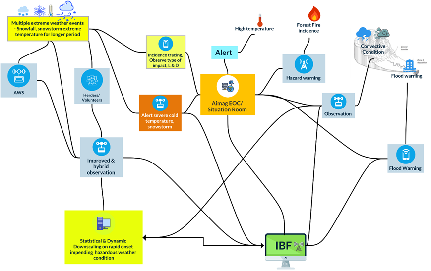
Figure 22 : Nowcasting, hourly, daily IBF for issuing multi-hazard early warning :
For complete design document, please contact….
For design, and installation at the country level, please contact Z M Sajjadul Islam
Email : zmsajjad@gmail.com
Call at WhatsApp & Cell Phone : +88 01711 979179
Skype : zmsajjad