Emergency Operations Center(EOC) Setup
Establishment of Multi-Hazard Early Warning System (MHEWS) in African Center of Meteorological Applications for Development (ACMAD) at Niamey, Niger.
Designed and Implementation by : Z M Sajjadul Islam
International Consultant – Multi-hazard Early Warning Expert of ACMAD (UNDRR Africa))
[ The researcher is strictly copyrighting by Z M Sajjadul Islam , Multi-hazard early warning Expert . For detailed knowledge, system design, ICT Technologies, Geospatial & IT Programmatic coding, and other issues related to Global Multi-hazard early warnings please email : zmsajjad@gmail.com. Call me at WhatsApp : +88 01711 979179 , Skype : zmsajjad ]
1.0 Chapter: Introduction and Objective………………………………………………………………………………… 8
1.2 Objective of the establishment of Multi-Hazard Early Warning System (MHEWS)…………….. 8
3.0 Current structure and Process of ACMAD…………………………………………………………………………. 10
3.1 About ACMAD:…………………………………………………………………………………………………… 10
3.2 ACMAD Vision :………………………………………………………………………………………………….. 11
3.3 ACMAD Major Areas of Interventions :……………………………………………………………………. 11
3.4 ACMAD Organogram:………………………………………………………………………………………….. 12
3.5 ACMAD capacity improvement programme for the stakeholders :………………………………… 13
3.6 ACMAD institutional linkages………………………………………………………………………………… 13
3.7 Current product and services……………………………………………………………………………….. 13
3.8 ACMAD role as continental impact-based multi-hazard advisory center………………………… 14
3.9 Different products of impact-based early warning…………………………………………………….. 15
3.10 CIMA Foundation Technical Supports for ACMAD…………………………………………………… 15
3.12 Updating of emergency operational plan and implementation………………………………… 15
3.13 ACMAD status of Rapid on-set extreme weather forecasting……………………………………. 15
3.14 Coordination mechanism of data exchange(inter-operability)……………………………………. 15
3.15 ACMAD stakeholders, partners are benefitting from ACMAD delivered services……………. 16
4.1 Upgraded Muti-hazard Continental Advisory Center (Continental advisory center ):……….. 18
4.2 CIMA Foundation Technical Supports for ACMAD……………………………………………………… 18
4.3 Installation and operationalization of myDEWETRA platform……………………………………… 19
4.4 Hydrometeorological analytical tools for MHEW Continental advisory center :………………. 19
4.5 Proposed activities for the multi-hazard risk and vulnerability analysis:……………………….. 19
4.6 Proposed coordination mechanism of data exchange at the continental and regional level 20
5.0 UNDRR support for establishment of Muti-hazard Continental Advisory Center……………………………. 21
5.1 Enhance the capacity of ACMAD in multi-hazard risk-informed tool development………….. 21
5.2 The objective of upgrading the ACMAD Muti-hazard Continental Advisory Center :………… 22
6.0 ICT structures of ACMAD Weather Watch Center:……………………………………………………………….. 23
6.1 Components of ACMAD Center……………………………………………………………………………… 23
6.2 Proposed additional infrastructures & tools for data access and process services…………… 24
6.2 PUMA Nowcasting input satellites, types, and functions :…………………………………………. 25
6.3 The main component Muti-hazard Continental Advisory Center (Continental advisory center ) 27
6.4 Proposed Data Linkage with Tropical Storm warning center at La Réunion :………………….. 29
6.5 Data Linkage with AUC, ICPAC, RECs, NHMS, Emergency management Focal Point:…………. 29
6.6 Proposed Data Linkage with WMO designated center:………………………………………………. 29
7.0 Muti-hazard Continental Advisory Center interoperability……………………………………………………… 31
7.1 The myDEWETRA 2.0 System Installation :………………………………………………………………. 31
7.2 Usability of myDEWETRA in Climate and disaster risk management :…………………………… 32
7.3 Usability of myDEWETRA in ACMAD’s Multi-hazard Forecasting, Risk & Vulnerability Analysis : 37
7.4 Multi-hazard early warning product development process :……………………………………… 37
7.5 Types of Products is intended to produce:……………………………………………………………… 38
8.0 The standard operating procedure (SOP) of MHEWS Center……………………………………………………. 39
8.1 Standard Operating Procedures ( SOP) of Muti-hazard Continental Advisory Center………… 40
8.2 Defined Roles under Standard Operating Procedures ( SOP)………………………………………… 41
8.3 Weather Observation Process :……………………………………………………………………………… 42
8.4 Forecast & Bulleting Development Process ::……………………………………………………………. 43
8.5 Forecasting Process :…………………………………………………………………………………………. 43
8.6 SOP on developing Alert Level……………………………………………………………………………… 48
8.7 Showcases myDEWETRA platform………………………………………………………………………… 49
8.8 Weather forecasting with myDEWETRA platform……………………………………………………… 53
8.9 myDEWETRA data harmonization for risk-informed tools development process…………….. 59
8.10 An Integrated Approach on Multi-hazard Early Warnings and Products Development ……….
process………………………………………………………………………………………………………………….. 66
8.11 Steps of Product development process………………………………………………………………….. 66
8.12 Types of Products and Services being intended……………………………………………………….. 67
9.14 Forecast Verification :………………………………………………………………………………………… 69
9.0 Coordination Mechanism for Data Exchange……………………………………………………………………… 70
9.1 Purpose of the Multi-hazard Early Warning Data Coordination Mechanism……………………. 70
9.2 Objectives of the Data Coordination & Exchange Mechanism………………………………………. 71
9.4 Actionable coordination Mechanism for Data Exchange……………………………………………. 74
9.5 Roles of AUC for the coordination…………………………………………………………………………. 77
9.6 Roles of RECs Level coordination…………………………………………………………………………… 77
9.7 Roles of ACMAD level………………………………………………………………………………………… 77
9.8 Roles of ICPAC level…………………………………………………………………………………………….. 78
9.9 Roles of Member States………………………………………………………………………………………. 78
9.10 Proposed coordination mechanism with WMO designated RSMC/RCC :……………………… 78
9.10 Recommendations of Coordination mechanism of data exchange……………………………… 79
9.11 ACMAD Products and Services for DRM………………………………………………………………………….. 81
9.12 ACAMD Products and services for coordinating multi-hazard preparedness planning :………………….. 81
9.13 Data Dissemination & Feedbacks Receiving Mechanism……………………………………………………… 93
9.14 The necessity of launching MHEWS web portal………………………………………………………. 93
9.15 Social journalism/Citizen through social media………………………………………………………. 93
9.16 Messaging with Telegram Apps…………………………………………………………………………… 93
9.17 Instance Messaging, voice /video calling :……………………………………………………………… 93
9.18 Uses of national media outlets and Community Radio…………………………………………….. 93
9.19 Some simplified users of MHEWS………………………………………………………………………… 94
10.0 Conclusion and Recommendations 95
Acronym
ACMAD African Centre of Meteorological Application for Development
ACPC African Climate Policy Centers
AEMET The State Meteorological Agency
AfDB African Development Bank
AMM Africa Media Monitor
ANECA Agencia Nacional de Evaluación de la Calidad y Acreditación
AU African Union
AUC African Union Commission
CBO Community Based Organization
CCDU Climate change & desertification Unit
CDSF Climate Development Special Fund
CEMAC Economic and Monetary Community of Central Africa
CEN–SAD Community of Sahel–Saharan States
CILSS Interstate Committee for Drought Monitoring in the Sahel
SIMMS The Cooperative Institute for Mesoscale Meteorological Studies
COMESA Common Market for Eastern and Southern Africa
CPC Climate Prediction Center
CSIS Climate Services Information System
CSO Civil Services Organizations
CW Continental Watch
DCPC Data Collection or Processing Center
DRM Disaster Risk Management
DRR Disaster Risk Reduction
EAC East African Community
EAMAC African School of Meteorology and Civil Aviation
ECA Economic Commission of Africa
ECCAS Economic Community of Central African States
ECMWF European Centre for Medium-Range Weather Forecasts
ECOWAS Economic Community of West African States
EMI European Meteorological Infrastructure
EOC Emergency Operations Center
EUMETSAT European Union Meteorological Satellite
EWEA Early Warning for Early Action
EWS Early Warning System
FY2E /FY2G/ Fengyun-4B Meteorological satellite Fengyun-4B
GFCS Global Framework for Climate Services
GFCS Global Framework for Climate Services
GLOFAS Global Flood Awareness System
GOES Geostationary Operational Environmental Satellites (GOES)
GOESW/ GOESE The Geostationary Operational Environmental Satellite
GTS Global Telecommunication System
ICPAC IGAD Climate Prediction and Application Center
ICRISAT International Crops Research Institute for the Semi-Arid Tropics
ICT Information and communication technology
IFRC International Federation of Red Cross
IGAD Intergovernmental Authority on Development
IGAD Intergovernmental Authority on Development
IPCC Intergovernmental Panel on Climate Change
IRD Institut de Recherche pour le Dévéloppement
IRI International Research Institute for Climate and Society
JASON2 The Jason-2/3 and Ocean Surface Topography Mission
LSAF Satellite Application Facility on Land Surface Analysis
METOP Meteorological Operational Satellite Program of Europe
MFI Meteo France International
MHEWS Multi-Hazard Early Warning System
MODIS Moderate Resolution Imaging Spectroradiometer
MS Member States
MSG – AFR Meteosat Second Generation (MSG)
MSG- IODC Meteosat Second Generation Indian Ocean Data Coverage
MSGAFR- MPEF Meteosat Meteorological Product Extraction Facility (MPEF)
NBA Niger Basin Authority
NDMO National Disaster Management Organizations
NGO Non Government Organzation
NGO Non Government Organizations
NHMS National Hydrological and Meteorological Services
NMHS National Meteorological and Hydrological Services
NOAA National Oceanic and Atmospheric Administration
OCHA United Nations Office for the Coordination of Humanitarian Affairs
PoA Programme of Action
PUMA Preparation for the Use of Meteosat in Africa
RARS Regional Advanced Retransmission System
RCC Regional Climate Center
RCOFs Regional Climate Outlook Forums
RDT Rapidly Developing Thunderstorm
RDT Rapid Developing Thunderstorm
RECs Regional Economic Communities
RSMC Regional Specialized Meteorological Center
SADC Southern African Development Community
SARAL Satellite with ARgos and ALtiKa
SAWIDRA Satellite and Weather Information for Disaster Resilience in Africa
SDG Sustainable Development Goals
SFDRR Sendai Framework for Disaster Risk Reduction
SoD Standing Orders on Disasters
SOPs Standard Operating Procedures
UKMO UK Meteorological Office
EMI European Meteorological Infrastructure (EMI)
UMA Arab Maghreb Union
UN United Nations Agencies
UNDP United Nations Development Programme
UNECA United Nations Economic Commission for Africa
VITO Belgium Remote Sensing Satellite
WHO World Heath Organizaiton
WIS World Meteorological Organization Information System
WMO World Meteorological Organization
WMS Weather Monitoring Services
1.0 Chapter: Introduction and Objective
Climate risks and vulnerabilities over the African continent are being characterized as multifaceted and climate extremes are increasingly growing as rapid on-set events. The weather and climate system over the continents becoming an erratic pattern as increasing temperatures, changing precipitation patterns and more extreme weather are threatening human health and safety, food and water security, and socio-economic development in Africa. Improving climate risk governance and coordination across the institutions & stakeholders, and putting strategic Disaster Risk Reduction (DRR) mechanisms in place is becoming the priority issue.
Recognizing the looming consequences of climate extremes, the establishment of a Multi-Hazard Early Warning System (MHEWS) for the African Union regions is recognized as the cornerstone for addressing the impacts and being prepared for the impending hazards. Essentially, African Union (AU) member states developed a new Programme of Action (PoA) for the implementation of MHEWS by aligning the Sendai Framework for Disaster Risk Reduction (SFDRR) 2015-2030 mandates for reducing the substantial reduction of disaster risk and losses in lives, livelihoods, health, the economies, assets (physical, social, cultural and environmental), businesses, communities and countries as a whole. The robust and innovative Early Warning Systems (EWS), will be enabled stakeholders and individuals for getting prepared for responding to the climate extremes. Prevailing the current set of climatic perturbations and to tackle to impacts, the duty bearer, the stakeholders, and the actors on the ground need for improved understanding of disaster risk in all its dimensions of exposure, vulnerability, and hazard characteristics; the strengthening of disaster risk governance, including national platforms; accountability for disaster risk management; preparedness to “Build Back Better”.
1.2 Objective of the establishment of Multi-Hazard Early Warning System (MHEWS)
African Union (AU) and its sub-organs needs readily available tailor-made risks informed tools for readiness to comprehensive disaster risk management, manifesting the policy implications at the supply side for improving disaster risk governance and risk-informed sustainable development planning. Objectives of the MHEWS as follows;
- Establish an agile and interactive early warning systems at all levels to facilitate mitigation, response and recovery to increasing frequency and intensity of natural hazards.
- Strengthen Africa’s participation in global weather and climate programs;
- Generating early warning on national leadership and disseminating Early warnings of impending hazards to relevant stakeholders, DRM focal points, humanitarian actors, vulnerable communities, individuals for getting them prepared for the impending disasters.
- Instrumentalizing AUC to being enabled to provide prompt advisories on early actions to undertaken by the AUC organs, sub-organs, continental, regional body and national focal points for preparedness, response, recovery of impending natural disasters.
- Analyzing data from the recent disasters already occurred such as cyclone, flood , flash flood, on the continent, and hazards such as droughts, floods, tropical storms and cyclones, pests and epidemics have constantly affected more than one country simultaneously. Even where such hazards occur locally, the severity in which these events have manifested could easily overwhelm localized response.
- Acquisition of weather parameters observation and forecast data, analyses with myDEWETRA platform, interpreting risk information relevant to impact based Early Warning for the taking early actions to stakeholders.
- EWS for Early Action and Trans-boundary Risk Management.
- Establish data coordination mechanism among African countries for improve access to climate information and services.
- Encourages African States to strengthen their early warning systems, including multi-hazard and impact based early warning with priority on hydrological and meteorological systems and the delivery of services
in understandable manner to end-users for enhanced preparedness, response, recovery and reconstruction’.
- UNDRR collaborated with the AU Commission and other partners to mobilize resources for the establishment of Multi-Hazard Early Warning System (MHEWS). 11)
3.0 Current structure and Process of ACMAD
ACMAD is a WMO Regional Climate Centre with capabilities to provide services for Disaster Risk Reduction. ACMAD was established to act as a continental reference center in meteorology and to promote its applications for the development of Africa. It was created in 1987 by the Conference of Ministers of the United Nations Economic Commission for Africa (UNECA) and the World Meteorological Organisation (WMO). ACMAD has been operational in Niamey since 1992. ACMAD is composed of 53 Member States, the 53 countries of the “Africa” continent. To ensure its mission, ACMAD functions primarily with meteorologists detached by its Members States.
The Centre is headed by the Director-General (DG) and the core service deliveries of the centers are to develop evidence-based weather, climate, water and related environmental information are essential for the implementation of SDGs and AU agenda 2063, is mandated to operate as the African RCC according to WMO international standards and positioning for climate action and governance over the continental level. ACMAD having over 34 years of experience in weather, climate, and related environmental services for planning and action and develop specialized weather forecasts, weather outlooks for supporting risk-informed development in Africa. ACAMD supports all Africa Union member countries for capacity building of the meteorologist by imparting on-job training and secondment.
ACAMD role has become essential for the implementation of Sustainable Development Goals (SDGs), the Paris Agreement, and the Sendai Framework for Disaster Risk Reduction in Africa, therefore, contributing to the African strategy on meteorology and the agenda 2063 of the African Union on “the Africa we want”. The need for enhanced and urgent climate action and governance on water, food, and energy security has been recognized at the highest global, continental and regional political levels.
International climate finance available for Africa is increasing, yet the continent has insufficient capacity to effectively access it. ACMAD has been sustained by a few member states’ contributions. In addition, since UNECA is considered the mature state of ACMAD, there is a need to improve governance and management systems to adequately handle its continental mandate. The previous ACMAD strategy (2010-2015) made some significant contributions but there is a need to develop a new strategy (2020-2023)[1] to address the current realities.
3.1 About ACMAD:
Who :
ACMAD was created in 1985 through resolution 540 of the UNECA Conference of Ministers of Economy and Finance for the purpose of acting as continental weather /climate watch and center of excellence for the applications of meteorology for development.
What :
This continental center enables provision of weather/climate monitoring, forecasts and reginal early warning on drought, tropical cyclones and other extreme weather /climate events
It builds capacity, develops methods and tools, strengthens Africa’s contribution to global weather and climate prorammes, establishes and shares database and undertakes research in meteorology.
How:
ACMAD provides products, information, knowledge, advices, methods and tools competencies and capabilities contributing to the implementation of the agenda 2063 of the AU, the African strategies on climate change , disaster risk reduction, and relevant sustainable development goals with emphasis
on goal # 13 on combating climate change. ACAMD enables NMHSs to benefit from funded programmes through continental projects with NMHSs as the main target group.
Why :
Whether and climate events has been identified as the most likely and impactful hazards on the economy and society. The economic impacts of recent droughts in Africa (i.e. 2015 ) and reached 2% of Gross Domestic Product in some African countries reducing by half hydropower production. National Meteorological and Hydrological Services (NMHSs) lack capacity to better prepare and deliver information required to increase resilience to disasters and adapt to climate change. ACMAD is requested to build capacity of NMHSs and regional centers to provide weather and climate services to reduce disaster impacts. It provides continental scale forecasts, advices and warning to the African Union., Regional Economic Communities ( RECS) and humanitarian organization’s for the contingency plans update and implementation.
3.2 ACMAD Vision :
To be a world class continental operational centre of excellence supporting all African countries to be well resilient to extreme events with increased ability to adapt to climate change impacts.
[1] http://154.66.220.45:8080/thredds/catalog/ACMAD/DG/statutorydocs/catalog.html
3.3 ACMAD Major Areas of Interventions :
- The role is to operate as Regional Climate Center of Africa
- Mandate over the 54 countries
- Support to run Regional Climate Outlook Forums(RCOFs)
- Coordination with the African Union, African Union Commission, and other relevant pan-African bodies (e.g. Pan-African parliament)
- Capacity support to RCCs for them to play a full role as RCC (capacity transfer, schedule, and plan)
- Maintenance of Pan-African hydro-met database, and baseline count of observation networks in Africa
- Continental Weather and Climate Modeling Impact modeling
- User-tailored services at the continental scale
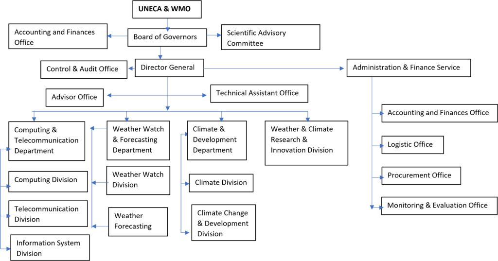
Figure 1 : ACMAD Organogram
3.5 ACMAD capacity improvement programme for the stakeholders :
- Improved capacity to deliver “tailored” Weather & climate information services and products
- Improved capacity in the user community to effectively use and demand weather/climate information.
- Increased awareness and demand of weather & climate risk management techniques
- Improved contribution to effective early warning and response systems for climate‐related hazards
(Vulnerability aspects, relations with SNMHS, Regional Centers, CILSS,FEWSNET, IFRC, UNICEF…. )
- Improved communications and dialogue with Medias
- Specialized training to relevant professional and development practitioners in Africa;
- Appropriate research, data, and networking facilities to research programmes in Africa.
3.7 Current product and services
Table 1: Several products being produced by ACMAD
| Weather Watch & Forecasting Department | Climate & Development Department | Weather & Climate Research & Innovation Division | |
| A Daily Severe Weather Forecast Bulletin with continent-wide coverage and valid for 3 days; A continental-scale daily weather forecast bulletin for the general public, and distributed in both French and English; | Decadal Precipitation in % 7-day Rainfall Monitoring Bulletin, in which the previous 7-day rainfall events area summarized and the forecast is issued for the next 7 days; Vigilance Bulletin for Africa valid for 7days designed for DRM; | SASA_SASF_Bulletin WASA_WASF_Bulletin MODEL OUTPUTS UKMO on EUMETCAST Africa Wave Watch III Model | |
| Weather Watch & Forecasting Department | Climate & Development Department | Weather & Climate Research & Innovation Division | |
| Continental Watch Daily rainfall observation RDT, nowcasting (hourly to 24 hours), dust storm etc Maximum daily Temperature forecast: D-1; D; D+1; D+2; D+3 ITD & ITCZ positions Heavy rain / flood risk Daily Forecast Vigilance Bulletin for Africa valid for 3days designed for DRM; | Monthly drought monitoring and seasonal climate forecasts discussions and briefings highlighting the major climate features of the past 3 to 6 months and providing the climate outlook for the coming 3 to 4 months Weekly monitoring rainfall Weekly Forecast Long range forecasting product for Africa Vigilance Meningitis bulletin Dekadal Climate Bulletin Monthly climate bulletin Climate and health bulletin Hazard Outlook | RM3 Analysis and forecast of key elements characterizing the West African monsoon; Regional analysis and forecast of synoptic elements and atmosphere dynamics for Southern Africa and Western Africa region. |
3.8 ACMAD role as continental impact-based multi-hazard advisory center
The setup of a multi-hazard advisory center at ACMAD center is expected to be improving impact-based multihazard early warning system, analysis of extreme weather forecasts and multi-hazards with myDEWETRA and analytical GIS tools, and develop riks informed weather and climate information service delivery for the promotion of sustainable development of Africa. The improved continental advisory center will be able to provide support services for analysis of the extreme weather-induced multi-hazards exposures, risks, and vulnerabilities over the vulnerable sectors, vulnerable groups, and risk-informed development tools for the decision-making process.
Pertinent to performing the technical early warning operations and standard operation of the continental advisory center ACMAD will be able to produce extreme weather based continental watch (CW ) with the fixed schedule agreed for the continent
The second part of the process of continental advisory center to supplement AUC an event Situation Report (abbreviated as SitRep) highlighting the standing conditions of an on-set of just the disasters triggered by extreme weather events, over the ongoing or potentially be impending hazard events, (e.g., an approaching Tropical Cyclone), the incrementally to intensifying of flooding situation or fresh flooding to down streams territories, etc. SitRep should be prepared immediately after the disaster event (or in advance in case of any hydro-meteorological events, e.g. Tropical Cyclones) or pre-emptive to trigger a hazard event to disaster.
The African Union commission continental advisory center will be responsible for the collection of information, analysis of the information, and dissemination of the reports to all stakeholders or the general public when deemed to do so.
3.9 Different products of impact-based early warning
ACMAD expected to serving following products for the purposes of impact-based early warning ; a) Continental Watch
3.10 CIMA Foundation Technical Supports for ACMAD
The CIMA foundation will support procurement of infrastructures ( hardware and software) for risk analysis hazard monitoring and forecasting, prevention, preparation and response planning as component of MHEWS. Specific support for risk profile and assessment is expected.
3.11 Support from AUC Africa Media Monitor (AMM) on communication for emergency operational planning
ACMAD need to establish communication with Africa Media Monitor (AMM) at AUC to develop the catalogue of what the demand-driven climate-informed tools for disaster operational planning, e.g. what type of forecast will be supportive for emergency preparedness, response, and recovery planning.
3.12 Updating of emergency operational plan and implementation
Based on monitoring and forecasting products disaster management and civil protection body will be responsible for preparing , updating and implementation of emergency plans.
3.13 ACMAD status of Rapid on-set extreme weather forecasting
ACMAD providing RDT, nowcasting (hourly to 24 hours), dust storm etc. For the rapid on-set weather forecasting,
A Daily Severe Weather Forecast Bulletin with continent-wide coverage and valid for 3 days;
3.14 Coordination mechanism of data exchange(inter-operability)
ACMAD primary role is to acess to data , collection , data process , develop products, dissemination capacity. ACMAD provide continental watch, develop multiple meteorological products and services and tailoring for policy and planning desk for the risk-informed development planning process for the continental actors.
With having functional interoperability with other regional meteorological centers (RCC) , this center can have access to WMO regional focused centers for building a repository of data hubs for the continent under the WMO protocol. For strengthening the data repository, AMCAD need to have a coherent institutional linkage for following WMO centers;
- ACMAD coordination mechanism with other WMO designated RSMC/RCC for data sharing.
- Establish coordination mechanisms for data exchange with Data Collection or Production Centre (DCPC) e.g. Casablanca
- Coordination with WMO Information System (WIS) for developing and sharing global catalog services on weather information service, data exchange, management, and processing.
- Establish coordination EUMETCast for improving access to nowcasting services.
- Establish coordination with Regional Climate Outlook Forums (RCOFs) to produce consensus-based, user-relevant climate outlook products in real-time to reduce climate-related risks and support sustainable development.
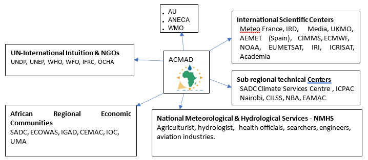
3.15 ACMAD stakeholders, partners are benefitting from ACMAD delivered services
A wide range of partners are benefitting from ACMAD delivered services;
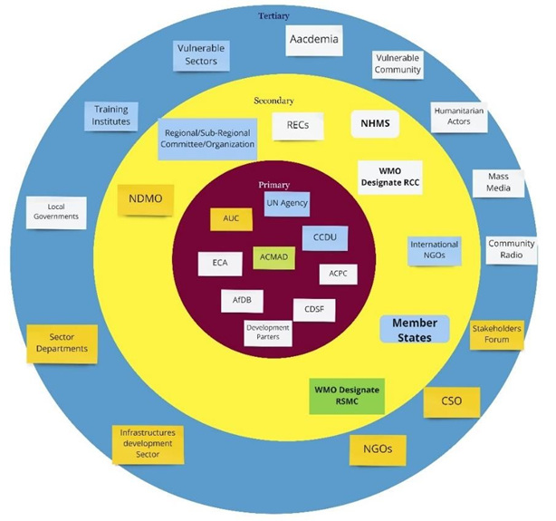
Figure 2 : ACMAD stakeholder map
| Stakeholder | Elaborations |
| AUC | African Union Commission |
| CSO | Community Services Organization |
| CCDU | Climate change & desertification Unit |
| UN | United Nations Agencies |
| ECA | Economic Commission of Africa |
| AfDB | African Development Bank |
| ACPC | African Climate Policy Centers |
| CDSF | Climate Development Special Fund |
| WMO | World Meteriologcail Center |
| RSMC | Regional Specialized Meteorological Center |
| NGO | Non Government Organzation |
| RCC | Regional Meteorological Center |
| NHMS | National Hydrological and Meteorological Services |
| REC | Regional Economic Commission |
| NDMO | National Disaster Management Organizations |
| NGO | Non-Government Organizations |
| CSO | Civil Services Organizations |
ACMAD have coordination with the following regional hubs and entities ;
- Regional Climate Outlook Forums (RCOFs), ECCAS
- New Partnership for Africa’s Development
- (NEPAD), the African Development Bank (AfDB), the World Bank, various intergovernmental organizations (IGOs).
- Various humanitarian agencies — including the International Federation of Red Cross and Red Crescent Societies (IFRC), the
- UN Agencies: UNDRR, World Food Programme (WFP), the UN Office for the Coordination of Humanitarian Affairs (UNOCHA), UNDP, UNDP, United Nations Children’s Fund (UNICEF), the UN International Strategy for Disaster Reduction (UNISDR)
- EUMETSAT, WMO, Regional and sub-regional partners
- Commission, the EU Delegations, and relevant International Organizations.
- Academia, R & Organzations
Benefitting Sectors of the continent;
- Agriculture and food security
- Water resource
- Energy production and distribution
- Public health
- Disaster risk reduction and response
- Outreach and communication
- Other sectors such as tourism, transportation, urban planning, etc. are increasingly involved.
4.0 Establishment of an Integrated and impact-based Muti-hazard Continental Advisory Center at ACMAD
UNDRR in collaboration with the African Union Commission (AUC) two designated regional climate centers (RCC) e.g. ACAMD and IGAD Climate Prediction and Application Center(ICPAC) partners to mobilize resources for the establishment of Multi-Hazard Early Warning System (MHEWS). Consequently, the Government of Italy financed UNDRR to support the establishment of Multi-Hazard Early Warning System (MHEWS) at continental level and pilot Regional Economic Committees (RECs) under the project entitled “Establishment of the impact-based early warning for early action and trans-boundary risk management function of the African Union” currently being under implementation.
The project intended to install their Continental advisory center at ACMAD, AUC, and ICPAC for developing impact-based early warnings and dissemination of informed tools to Regional Economic Communities (RECs) and the Member States, vulnerable sectors, emergency management organizations (focal Point) national hydrometeorological Service organizations (NHMS), humanitarian actors, vulnerable communities could impact by impending disasters.
4.1 Upgraded Muti-hazard Continental Advisory Center (Continental advisory center ):
Facilitate the establishment of a continental impact based EWS for Early Action and transboundary risk management through:
- Develop customized warnings on impending multi-hazards
- Developing specialized tools/ maps (GIS-based spatial analysis ) with giving the extent of areas potentially be impacted with advisories on impending (real-time) extreme hydrometeorological hazards those can potentially be impacted over and can cause damages to lives and properties.
- Establishment of a standard continental advisory center with having communications tools and common web-based platform and Standard Operating Procedures.
- Develop coordinate mechanism of data exchange at the continental and regional level
- Install myDEWETRA Open source platform at ACMAD for the operation exchange of information through access to real-time observation, forecasting, and other customized datasets for comprehensively analysis of risk and vulnerabilities and dissemination of early warnings and maps and tools.
- Integrating ACMAD forecasting product with myDEWETRA platform
- Provide input to AUC continental advisory center for developing Continental Watch (CW), event situation reports, and other multi-hazard advisories for immediate disaster risk-informed decision making.
4.2 CIMA Foundation Technical Supports for ACMAD
The core object of the project is to support ACMAD through the CIMA Research Foundation by providing technical support to set up the establishment of the Multi-Hazard Early Warning System (MHEWS) to provide impact-based early warnings for undertaking early actions and develop informed tools to facilitate transboundary climate risk management functions of the African Union.
The activities are envisaged under the establishment of MHEWS to set up a 24/7 continental advisory center at ACMAD center and the African Union Commission (AUC), is connected with three regional centers of the continent. The continental advisory center s are functioning and facilitating the exchange, monitoring, and analysis of meteorological data and risk-related information, based on the open-source platform myDEWETRA platform, developed by CIMA (CIMA Research Foundation) and owned by the Department of Civil Protection.
As ACMAD mandated for promoting meteorological services for supporting climate risk-informed development of African region. To strengthen impact based the multi-hazard early warning and enhance the capacity for data exchange and coordination among national, regional, and continental actors CIMA foundation extended technical support upgrading the warning system.
The technical supports are envisaged under the establishment of MHEWS to set up a 24/7 continental advisory center at ACMAD center with the installation of the open-source platform myDEWETRA platform which was developed by CIMA Research Foundation and owned by the Department of Civil Protection. Technically, the platform encompasses multiple weathers satellite-based integrated remotely sensed hydro-meteorological data capture, data processing, and providing observations of weather parameters, multi-hazards forecasting, and model analysis. In the context of current erratic climatic phenomena, it overserved that the hydrometeorological events are mostly transforming to rapid-onset while interacting over the ground. As result, the alert systems need to be upgraded with robust tools. Considering the growing weather and climatic perturbations CIMA supports extended for setting up the standardized continental advisory center that would be able to function and facilitate the exchange, monitoring, and analysis of meteorological data and risk-related information to end-users.
4.3 Installation and operationalization of myDEWETRA platform
myDEWETRA 2.0[1] is an open-source online platform for Earth System observation and prediction over meteorological observation, weather forecasting, earth observation, hydro-meteorological modeling, and geospatial multi-hazard risk/vulnerability analysis. The platform allows registered users to access datasets and to integrated data, regardless of the provider. The application manages, in fact, both the data provided by the National System of Functional Centres and the territorial and geospatial ones published as WMS services by other platforms. The platform can load and display geo-referenced static and dynamic layers and allows the endusers to browse the values of each gauging station and other more advanced observational tools, offering interactive tools and features for the analysis of ongoing and past events.
The myDEWETRA 2.0 to be installed with a Linux CentOS server with the ICT support from CIMA experts in the specialized situation at ACAMD premises for providing improved access to meteorological inputs, products, and services. UNDRR expert from ACMAD supported for installation of the platform.
4.4 Hydrometeorological analytical tools for MHEW Continental advisory center :
The proposed continental advisory center is expected to be the integration of the current set of weather watch instruments with newly proposed data capturing and analytical tools e.g. myDEWETRA, GLOFAS, EUMETCast, etc., for making ACMAD a robust center for weather watching, multi-hazard forecasting, multi-hazard exposure, risk and vulnerability analysis, and multi-hazard Early Warnings dissemination center.
4.5 Proposed activities for the multi-hazard risk and vulnerability analysis:
- Developing short-range Multi-hazard Risk analysis Map & Advisories: Analysis of the critical extreme weather parameters, that lead to different onset multi-hazards by analyzing all the forecast bulletins with GIS applications and develop a GIS risk map by showcasing the extent of areas being impacted or could be impacted over the next few days.
- Develop Monthly Multi-hazard outlooks maps and advisories: Develop decadal and monthly multihazard risk with special emphasis given to vulnerable socio-economic sectors, identifying vulnerable pockets where food security and livelihood sectors could largely be impacted. Develop sectors specific multi-hazards analysis over the continent at general, then RECs, States level multi-hazard exposure, risk & vulnerability maps.
[1] https://wikisrv.cimafoundation.org/index.php?title=User_Guide
- Develop sector-specific multi-hazard exposed map: Analysis of weather anomalies of the monthly, 3/4/6 monthly (change of weather parameters, e.g. rainfall in unseasonably, high temperatures, heatwave, dry spells, high humidity, strong winds, dust storm etc.) and determine and how those anomalies impacted for the lifeline sectors e.g. agriculture, water sectors, public health, environment and forest, social & livelihoods, etc., by analyzing with GIS tools and showcasing the extent of areas over the continental, REC region, and country-level and provide necessary advisories.
- Develop sector-specific multi-hazard exposed analytical maps for the year. Analyzing the whole year of the climatology of the continent and then prepare climate-vulnerable sector-specific GIS maps and advisories for risk-informed planning.
4.6 Proposed coordination mechanism of data exchange at the continental and regional level
ACMAD primarily intended to establish a continental advisory center provide continental watch ( weather forecasting) to AUC. ACMAD as a continental body can incentivize the multiple meteorological products and services for tailoring to support policy and planning desk for the riskinformed development planning process for the continental actors. UNDRR supports this center already supporting AUC with customized weather information and services data sources to make publicly available to interoperable formats. ACMAD can further play an important role to encourage the member countries to incentivized the spatial risk information by the regional, national, and local authorities with higher-level or data desegregation for sectoral risk analysis and developing the coherent institutional linkage and within the guideline of Sendai Framework.
The overall objectives of this coordination and exchange mechanism are to strengthen the AUC’s pivotal roles in establishing and improving the mechanism of dissemination of severe weather forecasts, facilitate interactive and effective communication, coordination for exchange of disaster emergency data and information on on-set disaster events at the local level, and subsequently preparing an event situation report on the occasion of disaster being declared by the Member states.
Level of institutional strengthening process;
- Establish ACMAD coordination mechanism with other WMO designated RSMC/RCC for data sharing.
- Establish coordination mechanisms for data exchange with Data Collection or Production Centre (DCPC) e.g. Casablanca
- Coordination with WMO Information System (WIS) for developing and sharing global catalog services on weather information service, data exchange, management, and processing.
- Establish coordination EUMETCast for improving access to nowcasting services.
- Establish coordination with Regional Climate Outlook Forums (RCOFs) to produce consensusbased, user-relevant climate outlook products in real-time to reduce climate-related risks and support sustainable development.
5.0 UNDRR support for establishment of Muti-hazard Continental Advisory Center
UNDRR has undertaken activities to develop Continental advisory center at the African Center of Meteorological Applications for Development (ACMAD), African Union Commission (AUC), and IGAD Climate Prediction and Application Center (ICPAC) being envisioned for comprehensive Disaster Risk Management (DRM) with the given priority of risk-informed preparedness plans, and, response, and post-disaster recovery and reconstruction mechanisms. The standard continental advisory center is required for the establishment of agile and interactive early warning systems at all levels to facilitate mitigation, response, and recovery to increasing frequency and intensity of natural hazards.
Continental advisory center at the ACMAD and simultaneously being linked and interacting with other prioritized centers e.g. African Union Commission (AUC), and the ICPAC. The center functional aspects of the warning center in how myDEWETRA & EUMETCast tools shall be facilitating in real-time and time-span hydro-meteorological data to be integrated, collecting, processing, real-time risk analysis and supporting multi-hazard risk-informed tools to AUC, its organs, and Member States(MS), and Disaster Risk Management Authorities at the continent level.
The goal of designing the ACMAD warning center to leverage the development of the strategic tool and upgrading ACMAD led time-series weather observation, forecasting, rapidly developing thunderstorm (RDT) and real-time based other multi-hazard early warning products in more upgraded ways by defining the approach.
For developing impact based multi-hazard maps, we need to append weather forecasts map with the GIS software to analyze the indicative weather impacts over the other geospatial features (settlements, agricultural lands, physical infrastructures & communication networks, natural resource elements, built-up physical installations, vulnerable pockets, standing croplands, freshwater bodies, etc.). In these aspects, ACMAD needs to have geospatial shapefiles from member countries) for analyzing geographical areas of extent falling in exposure, risk, vulnerabilities of impending muti-hazards.
5.1 Enhance the capacity of ACMAD in multi-hazard risk-informed tool development
The setup of a multi-hazard situation at ACMAD center is expected to be improving impact-based multi-hazard early warning system, analysis of extreme weather forecasts and multi-hazards with myDEWETRA and analytical GIS tools, and develop riks informed weather and climate information service delivery for the promotion of sustainable development of Africa. The improved continental advisory center will be able to provide support services for analysis of the extreme weather-induced multi-hazards exposures, risks, and vulnerabilities over the vulnerable sectors, vulnerable groups, and risk-informed development tools for the decision-making process.
Pertinent to performing the technical early warning operations and standard operation of the continental advisory center ACMAD will be able to produce extreme weather based continental watch (CW ) with the fixed schedule agreed for the continent
The second part of the process of continental advisory center to supplement AUC an event Situation Report (abbreviated as SitRep) highlighting the standing conditions of an on-set of just the disasters triggered by extreme weather events, over the ongoing or potentially be impending hazard events, (e.g., an approaching Tropical Cyclone), the incrementally to intensifying of flooding situation or fresh flooding to down streams territories, etc. SitRep should be prepared immediately after the disaster event (or in advance in case of any hydro-meteorological events, e.g. Tropical Cyclones) or pre-emptive to trigger a hazard event to disaster.
The African Union commission continental advisory center will be responsible for the collection of information, analysis of the information, and dissemination of the reports to all stakeholders or the general public when deemed to do so.
5.2 The objective of upgrading the ACMAD Muti-hazard Continental Advisory Center :
Facilitate the establishment of a continental impact based EWS for Early Action and transboundary risk management through:
- Develop customized advisory and watches on impending multi-hazards
- Developing specialized tools/ maps (GIS-based spatial analysis ) with giving the extent of areas potentially be impacted with advisories on impending (real-time) extreme hydrometeorological hazards those can potentially be impacted over and can cause damages to lives and properties.
- Establishment of a standard situation room with having communications tools and common web-based platform and Standard Operating Procedures.
- Develop coordinate mechanism of data exchange at the continental and regional level
- Install myDEWETRA Open source platform at ACMAD for the operation exchange of information through access to real-time observation, forecasting, and other customized datasets for comprehensively analysis of risk and vulnerabilities and dissemination of early warnings and maps and tools.
- Integrating ACMAD forecasting product with myDEWETRA platform
- Provide input to AUC situation room for developing Continental Watch (CW), event situation reports, and other multi-hazard advisories for immediate disaster risk-informed decision making.
6.0 ICT structures of ACMAD Weather Watch Center:
Weather watch, tracking extreme weather, processing forecast, analyzing impacts of forecasts and multi-hazards and timely dissemination of the warnings remote community, etc., essentially depend on Information and communication technology (ICT), hardware and software integrated system. The standard design of ACMAD warning center (Continental advisory center ) being targeted for 24/7 operability with an integrated system. Making system robust architecture, so that, it can be lined with live weather observation data from satellites, connecting with processed data hub (myDEWETRA), Global Flood Awareness System, drought, cyclone, fire, volcano, tsunami, etc., system and having common multi-hazard alerting and dissemination system.
Considering the African rapidly changing climatic phenomena and the extreme weather events recurrently impacting the continent with rapid on-set multi-hazard modality. The precision level weather forecasting, multihazard early warning are deemed the most challenging jobs. In addition to the existing ICT structures and facilities of ACMAD the proposed new situation will be able to promote meteorological services for supporting climate risk-informed development of the African region. ICT is supposed to play important role in strengthening impact based on the multi-hazard early warning and enhance the capacity for data exchange and coordination among national, regional, and continental actors CIMA foundation extended technical support upgrading the warning system.
Reviewing the current setup and identifying the indicative gaps of early warning service deliveries, the technical supports are to be envisaged by the establishment of an open-ended platform and inclusive participation of multi-stakeholders with both way trafficked information outflow to the early warnings in a timlely manner and to set up a 24/7 continental advisory center at MHEWS at ACMAD center with the installation of open-source platform myDEWETRA which was developed by CIMA Research Foundation and owned by the Department of Civil Protection. Technically, the platform encompasses multiple weather satellite-based integrated remotely sensed hydro-meteorological data capture, data processing and providing observations of weather parameters, multi-hazards forecasting, and model analysis.
6.1 Components of ACMAD Center
- PUMA[1] Nowcasting Station :
Under the current ICT structures of ACMAD watch center having the active link of PUMA 2015(Preparation for the Use of Meteosat in Africa) station which is installed under the MESA (Monitoring for Environment and Security in Africa ) project which is supported by MFI ( Meteo France International) provided real-time forecasting systems of the EUMETCast dataflow.
[1] http://www.mfi.fr/en/news–detail/an–all–in–one–aviation–solution–for–the–asecna.php
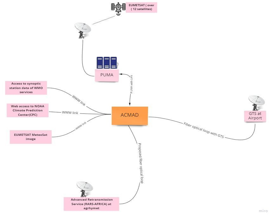
Figure 3: Current telecommunication setup of ACMAD
- Global Telecommunication System (GTS) Link with Airport
With ACMAD is accessing the global datasets though GTS .
3 ) Regional Advanced Retransmission System (RARS) Station Setup under SAWIDRA Project :
With support from satellite and Weather Information for Disaster Resilience in Africa (SAWIDRA) project ACMAD collects polar orbiting satellite data to be used for global and regional data assimilation in numerical weather prediction.
6.2 Proposed additional infrastructures & tools for data access and process services
Weather observation (satellite based and WMO synoptic station based ) Classified datasets essentially required multiple analysis to develop different range forecasting products and meteorological and climatological services. After review of the existing system the following indicative gaps has been identified and recurrent solutions given in the below table;
Table 2 : System Proposed additional infrastructures Instrumental and tools gaps of ACMAD watch center& tools for data access and process services
| SL | Gap | Solution |
| 1. | Redundant internet access | Optical Fiber |
| 2. | WMO Data access with DCPC/WIS | Establishing coherent coordination mechanism of data exchange |
| 3. | Interactive web dissemination | Deployment with new server ( Bluehost) |
| 4. | Hydrometeorological process data | myDEWETRA |
| 5. | Real time access to RARS service | Live data links with RARS |
| 6. | Hydrometeorological customized geospatial data | Access to myDEWETRA platform |
| 7. | Access to WMO product and services | Deploying WMO common alerting protocol, weather foresting apps, synoptic weather service API |
| 8. | In house data repository development from WMO global data hub | Installation and deploying several tools at High Performance Computing (HPC) system for processing classified weather parameters and using for weather and climatological products development. Access to myDEWETRA data sources Access to WMO, ECMWF data sources |
| 9. | Data format | Suitable format for meeting the purposes |
Real-time early warning dissemination required a geospatial platform (preferably opensource) and with the realtime pop-up messing interface and also android based apps ( web convert to apps ) downloadable from google play by the users to have the real-time popup of multi-hazard & disaster events over the online system. ACMAD still to harmonize this option.
For developing impact based multi-hazard maps, we need to append weather forecasts map with the GIS software to analyze the indicative weather impacts over the other geospatial features (settlements, agricultural lands, physical infrastructures & communication networks, natural resource elements, built-up physical installations, vulnerable pockets, standing croplands, freshwater bodies, etc.) . In these aspects, ACMAD need to have geospatial shapefiles from member countries) for analyzing geographical areas of extent falling in exposure, risk, vulnerabilities of impending muti-hazards.
By reviewing the ACMAD ICT system, it appears that the center having linkage with PUMA station and can have access to Meteorological Satellites images for real-time weather observations and also having Thredds sever application for accessing weather observations services from USA (NOAA) based climate prediction center (CPC), Meteo France for tracking Rapid Developing Thunderstorm (RDT) and another rapidly developed weather system.
6.2 PUMA Nowcasting input satellites, types, and functions :
Table 3: PUMA Nowcasting input satellites, types, and functions
| SL | Satellite Name | Satellite Type | Functions |
| 1) | MSG – AFR[1] | EUMETSAT currently operates the Meteosat -9, -10 and -11 in geostationary orbit (36,000km) over Europe and Africa, and Meteosat-8 over the Indian Ocean. | The Meteosat satellites are operated as a two-satellite system providing detailed full disc imagery over Europe and Africa every 15 minutes and rapid scan imagery over Europe, every five minutes. Meteosat imagery is crucial for nowcasting, which is about detecting rapidly developing high impact weather and predicting its evolution a few hours ahead, in support of the safety of life and property. Observations are also used for weather forecasting (as input to numerical weather prediction models), and for climate monitoring. Infrared Data accumulation of 15 minutes interval VIS 0.6-1.6 IR 3.9 -12.0 |
| 2) | MSG- IODC[2] | Indian Ocean Data Coverage (IODC) Service – Eumetsat | The IODC service provides level 1.5 image data, meteorological products, and a data collection and re-transmission service. It is similar to the 0 degree |
| SL | Satellite Name | Satellite Type | Functions |
| service. The IODC data can be accessed in near real-time via the EUMETCast Satellite and EUMETCast Terrestrial services. A sub-set of products are available via Global Telecommunications System (GTS). The full archive of data and products can be downloaded via the data centre. | |||
| 3) | MSGAFR-MPEF | The new MSG Meteosat | The active fire monitoring, fire detection product indicating the presence of fire within a pixel. The underlying concept of the algorithm takes advantage of the fact that SEVIRI channel IR3.9 is very sensitive to hot spots which are caused by fires. |
| 4) | FY2E /FY2G/ Fengyun-4B | FengYun-2, or FY-2 (FengYun means “winds and clouds” in Chinese), is the geostationary meteorological satellite series of China | Cloud type, amount and cloud top temperature Cloud particle properties and profile Liquid water and precipitation rate , Radiation budget Atmospheric Temperature Fields Land, Albedo and reflectance , vegetation ,Surface temperature (land), Multi-purpose imagery (land) Ocean Surface temperature (ocean), Multi-purpose imagery (ocean). Fengyun-4A/4B for water vapor detection channels in the geostationary orbit radiation imager and improved the spectrum of some channels. The design scheme of the geostationary orbit interferometric infrared detector is optimized, by which the satellite is capable of providing more accurate hyperspectural atmospheric radiation and temperature-humidity profiles. A newly equipped fast imager has the rapid imaging capabilities with a maximum spatial resolution of 250 meters, which can help to better monitor typhoon, rainstorm and other meso-scale disastrous weather. Fengyun-4B also adds Ka data transmission band to improve the data download capabilities. |
| 5) | GOESW/ GOESE | The Geostationary Operational Environmental Satellite (GOES), operated by the United States’ National Oceanic and Atmospheric Administration (NOAA) | National Environmental Satellite, Data, and Information Service division, supports weather forecasting, severe storm tracking, and meteorology research. |
| 6) | GOES-R | NOAA’s latest generation of Geostationary Operational Environmental Satellites (GOES), known as the GOES-R Series, | Improved hurricane track and intensity forecasts Increased thunderstorm and tornado warning lead time Earlier warning of lightning ground strike hazards Better detection of heavy rainfall and flash flood risks Better monitoring of smoke and dust Improved air quality warnings and alerts Better fire detection and intensity estimation Improved detection of low cloud/fog |
| 7) | VITO | VITO Remote Sensing for data, services and solutions in Earth observation | For daily global vegetation monitoring. GeoNetCast |
| 8) | LSAF | The LSA SAF (Satellite Application Facility on Land Surface Analysis) | Detection of radiation products, vegetation, evapotranspiration and wild fires. |
| 9) | MODIS | MODIS (or Moderate Resolution Imaging Spectroradiometer) is a key instrument aboard the Terra (originally known as EOS AM-1) and Aqua (originally known as EOS PM-1) satellites of NASA | MODIS helps scientists determine the amount of water vapor in a column of the atmosphere and the vertical distribution of temperature and water vapor— measurements crucial to understanding Earth’s climate system. |
| 10) | METOP | EUMETSAT operates Europe’s Metop-A, B and -C satellites, which circle the globe via the poles and continuously collect data from an altitude of 817 km. | MetOp-A polar-orbiting satellite has helped transmit data from thousands of animals, oceanographic buoys, weather stations, and other platforms around the world with its on-board Argos-3 instrument. The satellites carry a payload of eight main instruments and the data they collect are essential for weather forecasting up to 10 days ahead and climate monitoring. |
| 11) | JASON2 | Jason-2 is a follow-on satellite to the joint CNES/NASA oceanography mission Jason (or Jason-1, with a launch Dec. 7, 2001). | Designed for a three-to-five-year mission, the joint U.S./European Ocean Surface Topography Mission (OSTM) on the Jason-2 satellite has now made more than 47,000 trips around our home planet, measuring sea level change across the globe, observing ocean currents, studying climate phenomena such as El Nino and La Nina, . |
| SL | Satellite Name | Satellite Type | Functions |
| 12) | SARAL | SARAL (Satellite with ARgos and ALtiKa) | The development of operational oceanography (study of mesoscale ocean viability, coastal region observations, inland waters, marine ecosystems, etc. ) Understanding of climate and developing forecasting capabilities • Operational meteorology. |
| 13) | NOAA | National Oceanic and Atmospheric Administration (NOAA) | National Oceanic and Atmospheric Administration (NOAA)’s National Environmental Satellite, Data, and Information Service division, supports weather forecasting, severe storm tracking, and meteorology research. |
[1] https://www.eumetsat.int/our–satellites/meteosat–series
[2] https://www.eumetsat.int/indian–ocean–data–coverage–iodc
6.3 The main component Muti-hazard Continental Advisory Center (Continental advisory center )
As ACMAD mandates are concerned the center having portfolios for providing meteorological services as informed tools for sustainable development and climate resilience building at the continent level. The center is already equipped with PUMA, GTS, and RARS stations and having access to satellitebased atmospheric parameters observation & analysis and synoptic weather observations over the ground. ACMAD traditionally focuses on time-series products generation and giving importance to the impact based forecasting products. But fundamentally, Climate change is having a growing impact on the African continent, hitting the most vulnerable hardest, and contributing to food insecurity, population displacement, and stress on water resources . The mean annual temperature rise over Africa, relative to the late 20th century mean annual temperature, is likely to exceed 2°C which is expected to lead the severe weather events of diverse climatic patterns. Recurrent weather anomalies over sub-Saharan Africa and extreme weather events in any given season of the continent lead onset of internal and external migration, serious food insecurity. The ACMAD continental advisory center remains to be linked with other Continental advisory center of AUC(EOC), ICPAC, RECs, AU suborgans, Member States, and beyond.
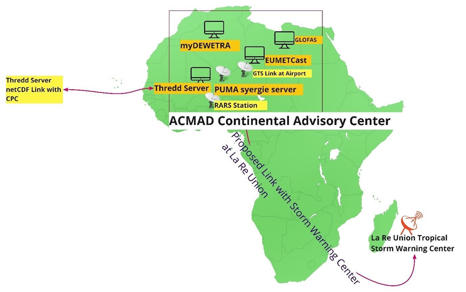
Figure 4: ACMAD Continental Advisory Center
- Installation and activation of myDEWETR : Over the given circumstances of extreme weather events, and impact-based early warning with continental scale and beyond being intended by the UNDRR. With CIMA research foundation support, installation, and configuration myDEWETRA geospatial platform & GLOFAS under implementation. This platform is multifaceted, open-ended, and interactive to designated users/stakeholders for products customization, sharing, and dissemination facilities. Having some useful key features on hydro-meteorological weather observations, multi-hazard forecasting, customized features on risk and vulnerabilities on vulnerable elements & population, basic infrastructures, and services. myDEWETRA having alerting protocol that can be father customized to disseminating real-time alerts with apps-based alerting ( web converting to app) over the android system.
- Installation of EUMETCast (updated) : New EUMETCast Africa service is being renovated by removing the old satellite and linking with EUTELSAT 8 West[1] . Since 1 May 2018 EUTELSAT 8W has been used for the new EUMETCast Africa service. ACMAD intended to install a new version of EUMETCast for having access to new data sources.
- Installation GloFAS : From 2018, the Global Flood Awareness System (GloFAS)[2] under the European Commission’s Copernicus Emergency Management Service is operational for forecasting and monitoring floods across the world. GloFAS prediction only focuses on rivers with ongoing and upcoming flood events, the evolution of streamflow forecasts is provided at reporting points on flash flood risk or coastal flooding. GloFAS data are freely accessible to all registered users through a dedicated web platform, the GloFAS map viewer. Detailed evolution of streamflow forecasts is provided at reporting points.
- Updated PUMA nowcasting Station: ACMAD having access to weather observation and monitoring PUMA 2015( Currently having to upgrade version 2020), which can provide around 12 Satellites capturing data covering across the Europe African, and the Indian Ocean and supplying satellite image, synoptic data for time-series weather observation, monitoring, and forecasting.
- Thredds Server[3] : Linux platform-based web server that provides metadata and data access for scientific datasets, using OPeNDAP, OGC WMS , and WCS, HTTP, and other remote data access protocols. Thredds dataset inventory Catalogs are being generated dynamically. This server access the NetCDF-Java/CDM library and processes multiple products. Currently, this server proving observation updates about Rapidly Developing Thunder Strom(RDT) every 15 minutes with Geo JSON format mapping format.
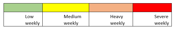
- GFS 5 days, weekly, WW3 consecutive 7 days precipitation accumulation: GFS 5 days, weekly, GFS WW3 7 days precipitation ( accumulation ) forecast and point( station) based warnings warning with showing threshold of danger level. Depending on the threshold of consecutive daily accumulation (mm) the system automatically provide color-coded thresholds for the point-based warning as following;
[1] https://www.eumetsat.int/new–eumetcast–africa–service
[2] https://www.globalfloods.eu/general–information/about–glofas/
[3] https://www.unidata.ucar.edu/software/tds/current/
- Rapidly Developing Thunderstorm (RTD)[1] : Rapidly Developing Thunder Strom(RDT) in every 15 minutes with Geo JSON format mapping format. Meteo France Rapidly Developing Thunderstorm
[1] Meteo France
(RDT), is an important tool for tracking the rapidly developing weather system at the growth, mature, and decay stage. This tool provides useful parameters of a weather system e.g. location, area of extent, duration of the system, stages, severity level, moving direction, the status of cloud phase, expansion rate, etc., which are very important for analyzing the nowcasting.
- Global Telecommunication System (GTS) Link with Airport: ACMAD having accessibility with an airport-level weather observation system observation for civil aviation. The GTS provides all airportlevel weather observation datasets.
- Regional Advanced Retransmission System (RARS) Station Setup under SAWIDRA Project :
With support from satellite and Weather Information for Disaster Resilience in Africa (SAWIDRA), ACMAD runs with data assimilation of both polar-orbiting satellites to obtained data from several satellites for weather observation purposes.
- The interface of several multi-models e.g. ICON, ARPEGE, GFS, ECMWF, UKMO, MEAN etc., for weather parameters of 24 hours of precipitation, temperatures, relative humidity and wind velocity etc.
6.4 Proposed Data Linkage with Tropical Storm warning center at La Réunion :
Meteo France installed Tropical Cyclones Centre at La Réunion is the WMO designated specialized center for watching weather depression over the western Indian Ocean and provide cyclone early warning for the eastern part of Africa. The data linkage with enabled ACMAD capacity in tropical storm warnings.
6.5 Data Linkage with AUC, ICPAC, RECs, NHMS, Emergency management Focal Point:
Technical support for the development of impact based multi-hazard early warnings at the precision level required recurrent coordination of disaster risk data and information data & information exchange from topto-bottom level ( end users) and subsequently bottom-to-top level e.g. AUC, AUCs organs, Sub organs, policy & planning, and programmatic desks, member states, Regional Economic & Communities (RECs), National HydroMeteorological Service (NHMS) Organization, nodal agencies of disaster management, humanitarian actors, vulnerable communities for having information of multi-hazards & impacts. Coordination with national level operationalizes multi-hazard emergency operations center (EOC) for dissemination of early warnings information & services.
Linkage with national level NHMS organizations for accessing the national level GIS datasets on multi-hazards for developing risk and vulnerabilities at the country level.
ACMAD needs processed climatic risk information/data (vector, raster image, shapefile) inputs for GIS-based customization of and detailed spatial analysis of multi-hazard perspectives for the wide range of stakeholders to support risk-informed planning.
6.6 Proposed Data Linkage with WMO designated center:
ACMAD having insufficient access to data and information exchange, coordination and active linkage with the WMO designated regional climate centers across the continent, and subsequently not having access to specialized customized tools for mechanizing holistic observation over every corner of the African continent and developing more qualitative informed continental watch at the end of the day. Although WMO over the 20202023 strategic plan envisioned to establish improved access to the exchange of data, information, and services, standardization, application, research, and training for capacity building of stakeholders for innovative approaches of service deliveries, ACMAD still needs to harmonize this option.
Linking ACAMD with the WMO specialized multi-hazard Early warning hubs of the African continent over the accessing to fastest onset multi-hazards warnings e.g. proposed linkage to La Réunion – Tropical Cyclone Warning Center (TCWP), storm surge predictions at the storm vulnerable areas, linkage with Vacoas marine meteorological center, Dar-es-salam and Pretoria WIS center for severe weather forecasting.
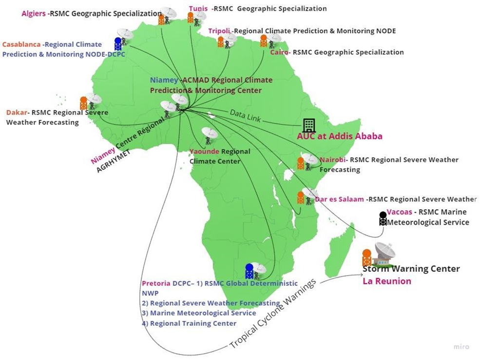
Figure 5: Proposed linkages among the WMO Regional Specialized Meteorological Centers
Stronger coordination mechanism amongst the continent level WMO designated Regional Climate Centers required to foster the optimally uses meteorological resources, facilitate weather & climate datasets, information, and knowledge products. ACMAD can play a pivotal role in establishing stronger linkages with those hubs for developing precision level meteorological services viz weather warnings, forecasts, and outlooks.
7.0 Muti-hazard Continental Advisory Center interoperability
The proposed Continental advisory center encompasses components of an integrated ICT system along with existing met data capturing satellite stations, additional components envisaged as e.g. open-source a) myDEWETRA platform, b) EUMETCast Platform, c) GLOFAS (Global Flood Awareness System), etc. for supporting impact-based forecasting services before facilitating multi-hazard early warnings and developing risk-informed downscale tools for the diverse stakeholders.
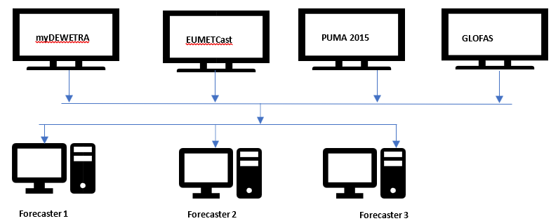
Figure 6 : Proposed nowcasting tools at Continental advisory center
7.1 The myDEWETRA 2.0 System Installation :
myDEWETRA 2.0 is an open-source online platform for Earth System observation and prediction over meteorological observation, weather forecasting, earth observation, hydro-meteorological modeling, and geospatial multi-hazard risk/vulnerability analysis. The platform allows registered users to access datasets and to integrated data, regardless of the provider. The application manages, in fact, both the data provided by the National System of Functional Centres and the territorial and geospatial ones published as WMS services by other platforms. The platform can load and display geo-referenced static and dynamic layers and allows the endusers to browse the values of each gauging station and other more advanced observational tools, offering interactive tools and features for the analysis of ongoing and past events.
Primarily myDEWETRA can be accessed by web at https://www.mydewetra.world for further user-level customization ( running scripts ) for developing specific products and running with these open-source systems, but for this purposes, this platform can be installed at a Linux server at the ACMAD continental advisory center
.
The myDEWETRA 2.0 can be installed with a Linux CentOS server in the specialized situation at ACAMD premises for providing improved access to meteorological inputs, products, and services. UNDRR expert from ACMAD supported for installation of the platform. The installations support by ICT experts of CIMA Research Foundation & UNDRR experts.
7.2 Usability of myDEWETRA in Climate and disaster risk management :
myDEWETRA provides datasets of several formats (TIFF image format, GIS shape file) in raster formats which is very supportive for exporting the products from the platform and importing by the QGIS, ArcGIS software’s and detailed analyzing it with other essential geospatial layers for more comprehensive spatial analysis of risks and vulnerabilities of the multiple sectors.
Table4 : myDEWETRA data harmonization and product development :
| Type of Weather Parameter | myDEWETRA Tools | Data acquisition frequency | Types of Data | Data processing instrument | Serving purposes for MHEWS and Risk informed tools | |||
| Observation | ||||||||
| Rainfall Observation | a) GHE-RAIN RATE (NOAA Global Hydro Estimator | 1 hour, 3-hour, 6 hours, 24 hour | Tiff Image: Satellite Raster Image with Legend of cooler coded and range | The imported TIFF file can be interpreted with QGIS/ ArcGIS Software for an accumulated amount of induced risk analysis by overlaying with other GIS features( socio-economic data, built-in physical infrastructures, environmental features, socio-economic sectors( agriculture, water resources, WASH, human settlements) and analysis if potential exposure, risks & vulnerabilities of the sectors by heavy rainfall and induced flooding on the ground. | Short-range of rainfall-induced hazards forecasts for the AUC, national Disaster Management Organizations, sectors, NHMS, humanitarian actors, stakeholders & vulnerable communities. | |||
| Rainfall Observation | Global Satellite Mapping of Precipitation (GSMaP) – NOAA, JAXA | Hourly | Tiff Image | Short-range of rainfall-induced hazards forecasts for the AUC, national Disaster Management Organizations, sectors, NHMS, humanitarian actors, stakeholders & vulnerable communities. | ||||
| Rainfall Observation | GSMaP Real-time | last 3 hours | Tiff Image : Satellite Raster Image with Legend of cooler coded and range | The imported GSMap realtime TIFF file can be interpreted with QGIS/ ArcGIS Software for analyzing the impacts of rainfall for nowcasting | Short-range of rainfall-induced hazards forecasts for the AUC, national Disaster Management Organizations, sectors, NHMS, humanitarian actors, stakeholders & vulnerable communities. | |||
| Rainfall Observation | IMERG -NASA of GPM | 24-hour accumulation(3 hours interval) | Tiff Image | NASA provided dataset being integrated as Satellite Raster Image with Legend of cooler coded and range being interpretable with GIS software’s | Short-range of rainfall-induced hazards forecasts for the AUC, national Disaster Management Organizations, sectors, NHMS, humanitarian actors, stakeholders & vulnerable communities. | |||
| Rainfall Observation | IMERG -NASA | 30 mins accumulation | Tiff Image : | NASA provided dataset being integrated as Satellite Raster Image with Legend of cooler coded and range being interpretable with GIS software’s | Nowcasting for rainfall-induced hazards forecasts for the AUC, national Disaster Management Organizations, sectors, NHMS, humanitarian actors, stakeholders & vulnerable communities. | |||
| Rainfall Observation | PR OBS 3 | |||||||
| Wind Observation | Surface wind ASCAT ( NOAA) | Tiff Image : | Current status of wind velocity and direction over the continents | |||||
| Drought Observation | SPEI (Standardized Precipitation Evapotranspiration Index) | 01, 03, 06, 09, 12, 24 months. | Tiff Image : | This observation layer can be interpreted with GIS software and developing the agriculture sector, livelihood, health, water resources, and other socio- | Drought Detection, Prediction, Sectoral vulnerabilities every month | |||
| Type of Weather Parameter | myDEWETRA Tools | Data acquisition frequency | Types of Data | Data processing instrument | Serving purposes for MHEWS and Risk informed tools | |||
| economical sectors risks, exposure, and vulnerabilities concerning drought severity over the sectors and livelihoods | ||||||||
| Drought Observation | SPEI -IRI (International Research Institutes for climate & society) SPI – IRI Data Library of Columbia University | 03, 06, 09, 12month | Tiff Image : | This observation layer can be interpreted with GIS software and developing the agriculture sector, livelihood, health, water resources, and other socioeconomical sectors risks, exposure, and vulnerabilities concerning drought severity over the sectors and livelihoods | Drought Detection, Prediction, Sectoral vulnerabilities every month | |||
| Cloud Cover Observation | MSG IR 10.8 of EUMETSAT | 15 minutes | Tiff Image | Analyzing the cloud masks /cloud presence | Cloud map over the continent | |||
| Soil Moisture Observation | Soil Moister water index being generated from Copernicus Global Land Service Providing biogeophysical products of global land surface. | 1, 5, 10, 15, 20, 40, 60, 100 years | Tiff Image ( raster ) | GIS tools-based analysis of Water Index quantifies the moisture condition at various depths in the soil which is mainly driven by the precipitation via the process of infiltration of 5cm soil depth[1] Soil moisture. | Planning of crop type suitability for seasonal agricultural cropping’s & land uses | |||
| Landslide Observation | NASA LHASA -Global Landslide Hazard Assessment Model. Landslide Hazard Assessment model for Situational Awareness (LHASA) has been developed to provide an indication of where and when landslides may be likely around the world every 30min. | 30min | Shape File | Can be interpreted with GIS software with other essential spatial GIS layers for analyzing the impacts of landslide over the settlements, livelihood, socio-economical, agricultural, and other vulnerable sectors. Excellent tools for interpreting landslide risks, exposure, and vulnerabilities and making forecasts considering the rainfall intensity, topographical, hydrological, geomorphological features over the landscape. | This model uses susceptibility (including vegetation, road geology, and forest cover loss) and satellite rainfall data from the Global Measurement (GPM) mission to provide moderate “nowcasts.” | networks, Precipitation to | surface slope, high | |
| Temperature Observation | Weather station based | Current Data available | not | |||||
| Landcover Observation | Dry matter productivity of Copernicus Global Land Service Providing bio-geophysical products of global land surface observation | TIFF File | Lake water quality can be interpreted with GIS software’s | |||||
| Landcover Observation | Lake surface water temperatures | Copernicus Global Land Service Providing bio- geophysical products of global land surface observation | TIFF File | Lake surface water temperatures can be interpreted with GIS software’s and analysis of climate change impacts | ||||
| Landcover Observation | Waterbodies | Copernicus Global Land Service Providing bio- geophysical products of global land surface observation on the presence of water | TIFF File | This is a very important layer for interpreting flooding levels, flooding forecasting, availability of water resources for agriculture and livelihoods, pollution, identifying water access points for agricultures, | Climate change impacts over the hydro-meteorological services, impacts over the multiple sectors, DRM, fluvial flood potential mapping, waterlogging mapping. Risk, exposure & vulnerability mapping over the sectors. | |||
[1] https://land.copernicus.eu/global/products/swi
| Type of Weather Parameter | myDEWETRA Tools | Data acquisition frequency | Types of Data | Data processing instrument | Serving purposes for MHEWS and Risk informed tools | |||||
| bodies over the continent | irrigation planning, water reservoirs mapping, climate change impacts over the water sectors. | |||||||||
| Landcover Observation | Lake water quality | Copernicus Global Land Service Providing bio- geophysical products of global land surface observation | TIFF File | GIS software for spatial analysis of water quality | ||||||
| Fire Observation | MODIS hotspots | Daily | TIFF File | EOSDIS integrates remote sensing and GIS technologies to deliver global MODIS hotspot/fire locations to natural resource managers and other stakeholders around the World. | Forecasting potential spots on forest and bush-fire | |||||
| Weather forecasting: | ||||||||||
| Rainfall forecasting | ECMWF ENS Decadal European Centre for Medium-Range Weather Forecasts(ECMWF ) ensemble system (ENS) tool | 10 days | TIFF File | GIS Software for interpreting rainfall intensity over the 10 days | Short-range stakeholders | forecasting | for | |||
| Rainfall forecasting | ECMWF ENS above 50mm ECMWF ENS above 50mm(current date only) : Provides % of the distribution of rainfall rate above 50 mm scale | Daily | TIFF File | GIS Software for interpreting the spatial distribution of rainfall over at the rate of 50mm | Short-range stakeholders | forecasting | for | |||
| Rainfall forecasting | ECMWF ENS above 150mm( | TIFF File | GIS Software for interpreting the spatial distribution of rainfall over at the rate of 150mm | Short-range forecasting flooding and flash flooding | of | |||||
| Rainfall forecasting | ECMWF ENS above 300mm | TIFF File | GIS Software for interpreting the spatial distribution of rainfall over at the rate of 300mm | Short-range forecasting of flooding and flash flooding | ||||||
| Rainfall forecasting | GFS 0.5 Before 13 June 2019 | TIFF File | GIS Software for interpreting the spatial distribution of rainfall over at the rate of 300mm | Analysis of aftermath of disaster impacts | ||||||
| Rainfall forecasting | WRF CRISIS : ( 4km Hayan 2013-11-06) | TIFF File | Analysis of aftermath of disaster impacts | |||||||
| Rainfall forecasting | WRF Crisis ( 6km Hayan 2013-11-06) | TIFF File | Analysis of aftermath of disaster impacts | |||||||
| Rainfall forecasting | WRF Crisis On-demand) | TIFF File | ||||||||
| Hydrological model | Global flood monitoring ( reporting points, seasonal outlook & reporting points, prediction of | 5 & 20 years return period | TIFF File | GIS Software for interpreting flood hazards, flood forecasting, reporting pointbased hydrological feature analysis, return period, etc. | Flood forecasting for the stakeholders and sectors | |||||
| Hydrological model | GLOFAS Seasonal Outlook & Reporting Points | 5 & 20 years return period | TIFF File | GIS Software for interpreting flood hazards, flood forecasting, reporting pointbased hydrological feature analysis, return period, etc. | Spatial distribution of floods, hotspot analysis, and Flood forecasting for the stakeholders and sectors | |||||
| Type of Weather Parameter | myDEWETRA Tools | Data acquisition frequency | Types of Data | Data processing instrument | Serving purposes for MHEWS and Risk informed tools | |||||
| Hydrological model | GLOFAS Flood reporting for 20 years of interval ( T =20 yrs) | 5 years return period | TIFF File | GIS Software for interpreting flood hazards, flood forecasting, reporting pointbased hydrological feature analysis, return period, etc. | Spatial distribution of floods, hotspot analysis, and Flood forecasting for the stakeholders and sectors | |||||
| Hydrological model | GLOFAS Flood reporting for 5 years of interval ( T =5 yrs) | 20 years return period | TIFF | GIS Software for interpreting flood hazards, flood forecasting, reporting pointbased hydrological feature analysis, return period, etc. | Spatial distribution of floods, hotspot analysis, and Flood forecasting for the stakeholders and sectors | |||||
| Fire Models | RISICO World | 7 hours over | interval | TIFF File | 17 variables/ parameters can be analyzed for forecasting potential fire hotspots | Spatial distribution of floods, hotspot analysis, and Flood forecasting for the stakeholders and sectors. | ||||
| Seasonal Forecast | ||||||||||
| IMPACTs Modeling | Flood Affected Population | |||||||||
| RISICO – Fire danger rating system | RISICO[1] model is a fire danger rating system that is adapted to the vegetation cover of the Mediterranean (). . | RISICO integrates meteorological observations and forecasts with vegetation cover and topography data. Modules describe dead fine fuel moisture conditions, the potential rate of spread, and the potential fire line Intensity. Forecasting experience revealed that it is important to take into account the persistency of very low fine dead fuel moisture content within 1-2 days | ||||||||
| Air Quality Observation | Particulate Matter | Trend can forecasted Copernicus | be by | |||||||
| Short-range Rainfall forecasts( NowCast) | • GSMAP NowCast ( JAXA and NASA) | |||||||||
| STATIC Layer Analysis | Exposure | Airport Dams GHS Population Density (2015) Global Human Settlement Global Railroad Network Global Road Network Health Facilities Power Plants | ||||||||
| Hazard Analysis | Hazard Analysis | a) GAR Flood Hazard 100 Years b) GAR Flood Hazard 1000 Years c) GAR Flood Hazard 200 Years d) GAR Flood Hazard 25 Years e) GAR Flood Hazard 50 Years f) GNB Flood Hazard Map T 25 | ||||||||
[1] Fiorucci et al., 2005; 2007; 2008; 2011
| Type of Weather Parameter | myDEWETRA Tools | Data acquisition frequency | Types of Data | Data processing instrument | Serving purposes for MHEWS and Risk informed tools |
| GNB Flood Hazard Map T 100 GNB Flood Hazard Map T 500 Hight Above Channel (SADC) JRC Flood Hazard 10 Years JRC Flood Hazard 100 Years JRC Flood Hazard 20 Years JRC Flood Hazard 30 Years JRC Flood Hazard 200 Years o) JRC Flood Hazard 500 Years | |||||
| Geospatial Layers | BAIC Layers | Admin Boundaries ( Level 0) Admin Boundaries ( Level 1) Admin Boundaries ( Level 4) Catchment Boundaries ( Level 0) Catchment Boundaries ( Level 4) Catchment Boundaries ( Level 5) Catchment Boundaries ( Level 5) Digital Elevation Model Flood Protection Global Lake and Wetland Database River network Global landcover DEM Flood protection Corin Landcover Woodland | The platform having interfaces to upload geospatial layers ( polygon, point, line ) for its WMS server | ||
| Multi-hazard Analysis | Flood risk analysis | Economical exploitation to flood Flood Risk (GAR) Physical exposition to flood | |||
| EVENTS mapping | Satellite Rapid Mapping (Hydro Scenarios) | Italy, Iran(MODIS), Serbia, Croatia, Kosovo Bosnia floods | |||
| Disaster Databases | EMDAT (Flood Bosnia, Serbia 2014) DESINVENTAR |
7.3 Usability of myDEWETRA in ACMAD’s Multi-hazard Forecasting, Risk & Vulnerability Analysis :
The myDEWETRA open-source platform having synchronized whether satellite-based tools for serving multiple purposes of weather observation, hydro-meteorological forecasts( short-medium range), multi-hazard mapping( flood, landslide, fire, cyclone, localized storms) those useful tools are essential to be enabled ACMAD in developing demand drive risk-informed tools development for 54 African Countries. This open-ended platform supporting ACMAD in developing evidence-based weather, climate, water, and related environmental information is essential for providing sector-specific risk information as informed tools for sectoral development planning and programme/project implementation.
The system is expected to enhance ACMAD’s technical capacity in strategizing country-level climate risks and vulnerability assessment tools development, Pre-disaster preparedness planning, post-disaster emergency response, and recovery planning and will be able to support counties in establishing a new paradigm of informed tools based disaster risk management strategies. Open source myDEWETRA 2.0 platform facilitates ACMAD in developing impact-based multi-hazard early warning s with showcasing the hazard hotspot over the continent map.
7.4 Multi-hazard early warning product development process :
The approaches are to synchronize the existing interfaces at the satiation room so that forecasters can have simultaneous observation with all available nowcasting services
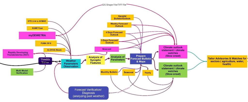
Figure 7: Multi-hazard Early Warnings development and multi-hazard risk-informed advisory development process
- Step 1: Data acquisition (Weather parameter observations): Forecasters are expected to have access to and view the myDEWETRA , GloFAS, and other existing nowcasting interfaces under the observation process. For Rapidly Developing weather events, review the RDT interface and interpret the consequences and provide the forecast.
- Step 2: Analysis of the synoptic features: Along with the satellite-based nowcasting, forecasters need to concurrently analyze the synoptic charts of ground stations for current and past weather and examine the previous situation and also anticipate future evolution e.g. convective system is decaying and increasing which needs to consider for the forecasting. Forecasters regularly use PUMA stations for the analysis, now myDEWETRA platform will provided added value for GIS based analysis with other attribute features.
- Step 3: Analysis of all atmospheric Parameters: Forecasters need to the analysis of critical synoptic drivers e.g. ITD ( Inter-Tropical Discontinuity ), analyze the movement of monsoon flux, in case of the West African Monsoon period, the moist air coming from the south and dry air coming for the north, deep convection occurs south of the ITD, wind velocity and direction, CAPE( Convective available potential energy) of the atmosphere, tracking information about the convention, convergence or divergence, Analysis Relative Humidity, ( Wet-bulb potential temperature) and other essential parameters.
- Step 4: Prepare the time-series forecast map: After analyzing all parameters of the region-specific diverse weather system, the forecaster’s job is to prepare a different range of forecasting products and bulletins of the continent.
- Step 5: Prepare the multi-hazard map on extreme weather events with GIS tools :
This step, basically to be handled by the disaster risk management professional for interpretation of weather outlook products and extreme events with GIS software by overlaying multiple variables(geospatial layers) for comprehensive multi-hazard exposure, risk and vulnerabilities, developing special-purpose customized maps for disaster risk management, emergency preparedness, response and rehabilitation mapping for the vulnerable sectors, vulnerable communities and risk management stakeholders on the national and local level.
7.5 Types of Products is intended to produce:
- Short-range forecasting ( Rainfall observation of Nowcasting, Daily, Weekly): Short-range Forecasts (12 hours to a few days) e.g. Heavy rainfall, strong winds, Floods, Flash floods, Tropical Cyclones,
- Medium-range Forecasts (a few days to two weeks) –Floods, flash floods, strong winds, tropical Cyclones,
- Extended-range Forecasts (two weeks and beyond) – Multi-hazards forecast and risks map on maps on heavy
Rainfall, Strong winds, high temperatures, localized thunderstorm, droughts, and other Severe Weather bulletins
- Extended-range Forecasts (two weeks and beyond) – Multi-hazards forecast and risks map on maps on heavy
Rainfall, Strong winds, high temperatures, localized thunderstorm, droughts, and other Severe Weather bulletins
- Extended-range Forecasts (two weeks and beyond) – Droughts and Severe Weather Monthly and Seasonal
Forecasts – Droughts
- Monthly and Seasonal Forecasts –Monthly and seasonal forecasts continue to improve, developed Multi-hazards maps occurred, a monthly bulletin on heavy Rainfall, Strong winds, high temperatures, localized thunderstorms, droughts, and other Severe Weather bulletins, Monthly Climate Diagnostic bulletin for Africa (RCC).
- Long-range forecasting: Seasonal precipitation forecast, weather(parameter) anomalies, Seasonal temperature forecast map, African seasonal precipitation average map, Seasonal climate forecast bulletin (RCC), seasonal rainfall, and another parameter variability, customized multi-hazards forecast map for development sectors and other customized map.
- Numerical Weather Prediction (NWP) model outputs (D1, D2, and D3 rain accumulation forecast), ITD positions (D1 up to D3), and other relevant outlooks.
- Monthly and seasonal forecasts continue to improve by using myDEWETRA platform.
- Rapidly Developing Thunderstorm (RDT) and rapid on-set weather events.
8.0 The standard operating procedure (SOP) of MHEWS Center
The standard operating procedure (SOP) of Africa Multi-Hazard Early Warning and Action System for DRR Continental Continental advisory center is designed for the African Center of Meteorological Applications for Development (ACMAD) and simultaneously being linked and interacting with other prioritized centers e.g. African Union Commission (AUC), and ICPAC. This SOP being well articulated with a set of the guideline of technical and functional aspects of how myDEWETRA & EUMETCast tools shall be facilitating in real-time and time-span hydro-meteorological data to be integrated into the system, data collecting, processing, real-time risk analysis and supporting multi-hazard risk-informed tools to AUC, its organs and Member States(MS), and Disaster Risk Management Authorities at the continent level with the given priority of risk-informed preparedness plans, and, response, and postdisaster recovery and reconstruction mechanisms.
The Standard Operating Procedures (SOP) of ACMAD Continental advisory center is a toolkit that is expected to provide integrated and strategic guidance to Continental advisory center Officers (forecasters), Weather department of ACMAD, AUC, and IPAC continental advisory center s, and other operators of the regions to operating robustly.
This SOP provides the strategies for the effective data capture, data process, time-spanning forecasting products, early warnings, and relevant climate information and services to stakeholders engaged in disaster and climate emergencies e.g. , DRM focal points, humanitarian actors, NHMS organizations, vulnerable service sectors at the country and national level of the Africa Continent.
SOP being intended to give the leverage of data exchange mechanism, data communication, coordination, in-house knowledge collaboration, and tools sharing among the AUC, ACMAD, ICPAC, and other connected agencies.
Apart from the business as usual of weather-watching, the CIMA foundation intended to upgrading the ACMAD watch center to provide multi-hazard early warnings ( MHEWS) by deploying the myDEWETRA platform. The mechanism being envisaged to establish MHEWS and to set up a 24/7 continental advisory center at ACMAD center with the installation of open-source platform myDEWETRA. This platform is developed by CIMA Research Foundation and owned by the Department of Civil Protection. Technically, the platform encompasses multiple weather satellitebased integrated remotely sensed hydro-meteorological data capture, data processing and providing observations of weather parameters, multi-hazards forecasting, and model analysis.
More importantly, the establishment of myDEWETRA based MHEWS at the ACMAD Continental advisory center and standardized operation of the platform will improve climate and weather information services to the relevant stakeholders for the climate-resilient sustainable development of the Sahel region and the beyond.
8.1 Standard Operating Procedures ( SOP) of Muti-hazard Continental Advisory Center
The main hazards affecting the African continent are related to extreme weather events. These include heavy rainfall, strong winds, floods, rainfall-triggered landslides, tropical cyclones, drought. The continent is affected by other hazards such as earthquakes, volcanoes, tsunamis, extreme heat, etc. The Continental Watch report will offer a general overview of all the potential natural threats, assessing with a predefined color coding (green, yellow, orange, and red) related to their possible severity.
These Standard Operating Procedures are divided into two parts. The first one is for developing and disseminating CWs and the second is about developing and disseminating SitReps by ACMAD and ICPAC. Pertinent to performing the technical early warning operations and tools, the continental advisory center shall be issuing two kinds of reports, according to the fixed schedule agreed. The first report is the Continental bulletin (hereinafter, CW) twice a week. This bulletin shall reflect a scan, observe and forecast of the weather and climate system of the whole continent that could potentially lead to any disaster and providing advisories for DRM. Other early warning institutions will be consulted as the situation dictates to provide information for the continental watch reports.
The second part of the process of continental advisory center to supplement AUC an event Situation Report (abbreviated as SitRep) highlighting the standing conditions of an on-set of just the disasters triggered by extreme weather events, over the ongoing or potentially be impending hazard events, (e.g., an approaching Tropical Cyclone), the incrementally to intensifying of flooding situation or fresh flooding to down streams territories, etc. SitRep should be prepared immediately after the disaster event (or in advance in case of any hydro-meteorological events, e.g. Tropical Cyclones) or preemptive to trigger a hazard event to disaster.
The African Union commission continental advisory center will be responsible for the collection of information, analysis of the information, and dissemination of the reports to all stakeholders or the general public when deemed to do so.
It is however highly mentionable that the stakeholders are now demanding a detailed landscape of spatially analyzed best risks informed (the climate riks and vulnerability GIS-based spatial analytical maps) tools for supporting policy, program, project planning, and decision making desks for evidencebased development project planning, design, implementation, monitoring and largely to achieve the SDG goals.
The primary objective of the MHEWS is to enhance the capacity of ACMAD to produce spatial maps/tools and to timely supplement to AUC, its sub-organ, regions, and county focal points to take early actions for impending disasters.
The goal of the SOP of the ACMAD warning center is to leverage the development of the strategic tool and upgrading ACMAD led time-series weather observation, forecasting, rapidly developing thunderstorm (RDT), and real-time based other multi-hazard early warning products in more upgraded ways by defining the approach.
Improving Nowcast: By using the multiple sources of satellite-based real-time weather observations, consequence analysis with leveraging additional analytical tooms e.g. myDEWETRA platform, Global Flood Awareness System (GloFAS), and access to EUMETSat Cast at the Continental advisory center of ACMAD.
Improving Forecasts: At the outset of installed MHEWS and upgraded continental advisory center at ACMAD center being enhanced the capacity of ACMAD in producing different range real-time and different range of forecasts (RDT, Short-range, medium-range, long-range, decadal, monthly, and seasonal) and outlooks at the precision level. Accuracy of different range forecasts is being highly demanded by the AUC, its organs/sub-organs, NHMS organizations, DRM actors at the national and local level.
Impact-based Forecasts: A customized forecasting system to be scaled-up by the deployment of the myDEWETRA platform, Global Flood Awareness System (GloFAS), and access to EUMETSat Cast at the Continental advisory center of ACMAD.
Multi-Hazard Early Warnings: As the weather and climatic phenomena being rapidly changing of climatic system and perturbations over the early and African continent particularly, the need for MHEWS are mounting. The SOP is intended to set out the procedures of MHEWS at the ACMAD with the existing system in place.
Coordination, Communications, and Advocacy: Objectives to establish communication strategies with AUC and beyond for strengthening ties with stakeholders for knowledge, information sharing, sharing the effectiveness and efficacy of climate information products and services for matching the needs of NHMS organizations. Sharing the best practices, actively engage with focal points/nodal agencies, local governments, sector departments, local actors, media outlets, and build the value proposition being offered by the continental advisory center .
8.2 Defined Roles under Standard Operating Procedures ( SOP)
Forecasters: ACMAD continental advisory center s being equipped to facilitate forecasters with for observation (space satellite-based observation and terrestrial synoptic stations based) and acquisition of atmospheric weather parameters from different interfaces e.g. myDEWETRA, PUMA, GLOFAS, GTS links. Forecasters’ jobs as forefront watchdog to weathers parameters and analyzing. Forecasters regular activities to monitor atmospheric conditions every hour and provide nowcasting.
Synoptic Analysis Team: Verify the fundamentals of weather analysis and forecasting, interpretation of surface observations( with WMO synoptic stations), satellite-based observations, verifying the multi-modal forecasts simultaneously, running forecast ensemble process, forecast diagnosis, forecast verification and finalize the forecast.
Data Analysis Team: Find the available climate datasets from the DCPC, WIS, fetch data, and readily made them available to develop multipurpose climate modeling.
Climate Team: Analysing of short-range forecast( 3 Days, 4 days ), analysis of meteorological data from other regional WMO centers (DCPCs, WIS), Center for climate prediction center ( CPC), EUMETSAT stations, etc and provide a different range of products Medium-range Forecasts (decadal to two weeks) – Tropical Cyclones, Floods, etc. Extended-range Forecasts (two weeks and beyond) – Droughts and Severe Weather etc. Extendedrange Forecasts (two weeks and beyond) – Droughts and Severe Weather. Monthly and Seasonal Forecasts – Droughts, weather anomalies, agricultural droughts, seasonal variation of climates. Analysis of climatic variables and prepare detailed forecast maps on monthly, seasonal and yearly, and beyond.
Multi-hazard risk analysis and Mapping Team: Using hazard forecasting bulleting, multi-hazard mapping expert responsibilities to analyze the sector-specific multi-hazards exposure, risks, and vulnerabilities and produce customized early warning maps for the sectors.
Climate Model Team: Responsibilities torun the model and develop forecast, long-range forecast bulleting, specialized sector-specific customized bulletins, weather outlook, monthly, yearly outlook, and multi-hazard maps.
8.3 Weather Observation Process :
7 Days Forecasts: WAVEWATCH III (WW3) Model: Using the THREDDS NetCDF Subset Service is an excellent tool for giving a forecast for consecutive 7 days.
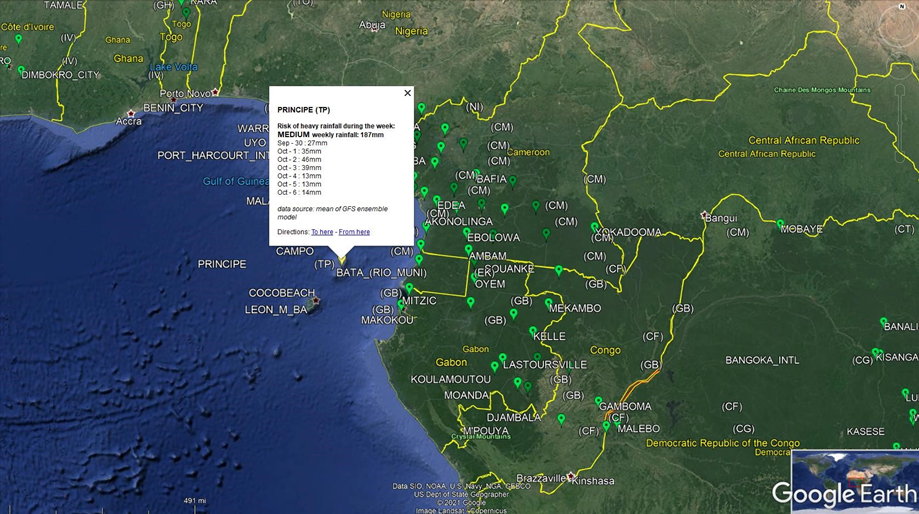
Figure 8 : Green Bubble showing the normal thresholds precipitation projections
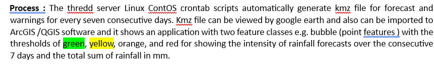
7 Days warning :
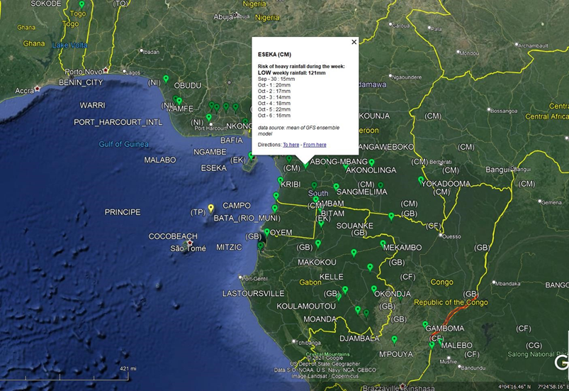
Figure 9 : 7 Days warning
http://154.66.220.45:8080/thredds/catalog/WW3/7day/catalog.html
Source: Catalog http://154.66.220.45:8080/thredds/catalog/WW3/1day/warning/catalog.html
8.4 Forecast & Bulleting Development Process ::
Figure10: Forecast & Bulleting Development Process
8.5 Forecasting Process :
Step 1: Analysis of past weather : a) Analysis with Satellite images :
PUMA nowcast
- The purpose is it review the forecasting accuracy by reviewing the last forecasted time lead(days) of satellite captured images from the sky. Review the weather system being prevailed those days and examine all parameters previous days and identify the point of forecasting gaps.
- Analysis of past convective system of decaying and increasing that need to consider for the next level of the forecast. Forecasters regularly use real-time nowcasting for this analysis.
- Analysis of forecast and statistical forecast data
Analysis of the corresponding Synoptic chart: Rerecorded by the ground-based WMO-designated synoptic ground observation weather stations across the continents ( around 1000 met stations in Africa according to WMO).
Step 2: Analysis of ITD (Inter-Tropical Discontinuity) :
a) Analysis of the limit between dry air ( harmattan[1] ) and moist air( monsoon), wind flow, deep convention, mean sea level pressure, etc. The diurnal cycle of ITD[2], i.e. the interface at the ground between moist monsoon air and dry Harmattan air, is an important factor in the West
African monsoon system. During the whole of 2006, high-resolution ground-based remotesensing measurements were performed in the area of Djougou, Benin, which made it possible to observe the ITD and the associated sharp gradient of temperature and humidity in detail.
[1] https://en.wikipedia.org/wiki/Harmattan
[2] Article in Quarterly Journal of the Royal Meteorological Society · January 2010
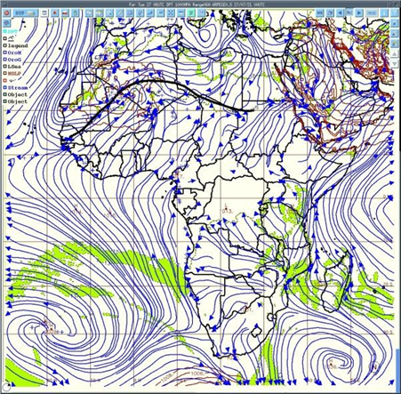
Analysis of the movement of monsoon flux, the moist air coming from the south and dry air coming from the north. Deep convection occurs south of the ITD.
Step 3: Analysis of the synoptic drivers :
- Analysis of Winds ( at 925 hPa[1] to analyze the monsoon flux ) velocity and direction
- Analysis of heat low ( area of low pressure which is the center of action of meteorology )
- Analyzing 850 hPa to observe wind vorticity
- 700 hPa to observe African easterly waves (AEWs) and wind direction
- Analyzing 600 hPa wind direction, AEWs, and African easterly jet (AEJ) which is very important for the convection
- Geopotential 500 hPa and temperature at 850 hPa
- Analysis 200 hPa to observe Tropical Easterly Jet (JET) and STJ ( Sub Tropical Jet)
Step 4: Analysis of deep convection parameters
[1] The unit for pressure is hectopascals (hPa)
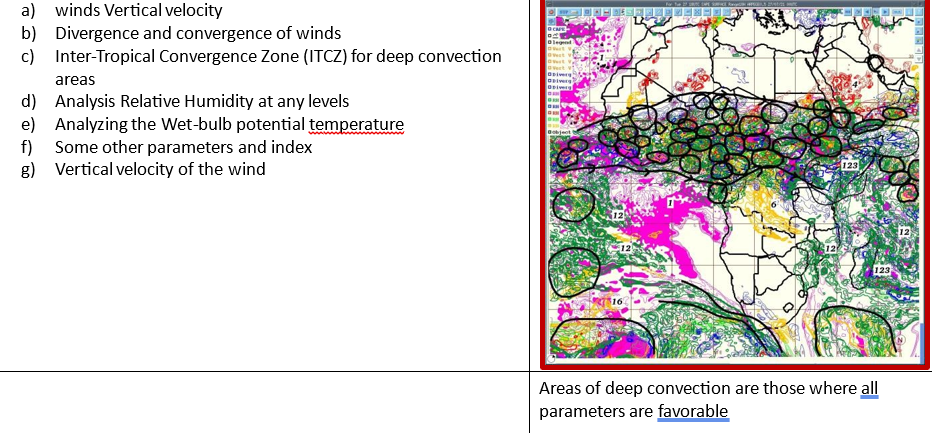
Step 5: Analysis Deep Convection over Africa through areas common values of followings;
a) Convergence (at low level) , Convergence( at medium level ) , Divergence( high level ) structures to updraft airmass
- Good value CAPE
- Very good value of Vertical velocity
- High values of relative humidity through all the troposphere
- Taking in account of synoptic drivers
The unit for pressure is hectopascals (hPa)
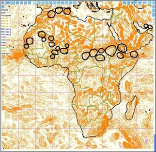
Area with high vertical velocity
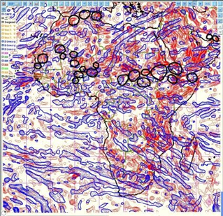
Low & mid-level convergence or divergence ( airmass)
Convective Available Potential Energy (CAPE)[1] CAPE stands for convective available potential energy, and it is a useful tool for determining the severe weather potential at a given location at a given time. Using CAPE to Forecast Severe Weather.
[1] https://study.com/academy/lesson/convective–available–potential–energy–cape–definition–use–inforecasting.html
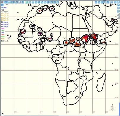
Step 6: Prepare Forecast map and Bulletin :
Determine areas where deep convection is supposed to occur with the type of rainfall and its intensity and showing strong winds and giving warnings of weather based on heavy rainfall and strong winds. Forecasting of convection
Step 7: Forecast verification
Satellite images to indicate where deep convection occurs and synoptic data give an indication of registered rainfall at the synoptic (WMO) station across the African continent ( around 1000 stations).
8.6 SOP on developing Alert Level
Most countries choose to customize their alert levels. A simple yellow, orange, red system is used by the Irish Meteorological Service (Irish Early Warning System). Simple, easy to understand, actionable.
Yellow – Weather Alert – Take preventative action. It is implicit that Yellow level weather alerts are for weather conditions that do not pose an immediate threat to the general population, but only to those exposed to risk by nature of their location and/or activity.
Orange – Weather Warning – Be Prepared for the category of ORANGE level weather warnings is for weather conditions that can impact significantly on people in the affected areas. The issue of an Orange level weather warning implies that all recipients in the affected areas should prepare themselves in an appropriate way for the anticipated conditions.
Red – Severe Weather Warning – Take Action The issue of RED level severe weather warnings should be a comparatively rare event and implies that recipients take action to protect themselves and/or their properties; this could be by moving their families out of the danger zone temporarily; by staying indoors; or by other specific actions aimed at mitigating the effects of the weather conditions. This level of warning assumes high confidence in the event occurring. Any false warnings could lead to unnecessary panic and loss of credibility.
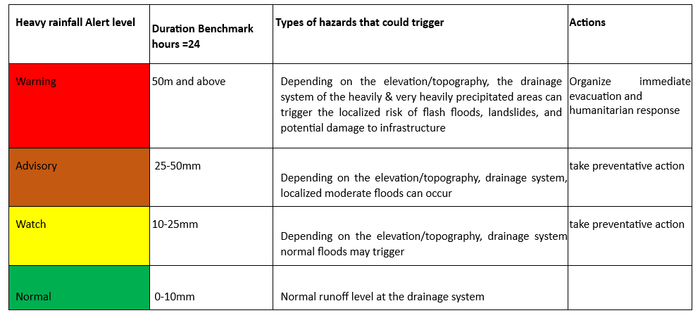
8.7 Showcases myDEWETRA platform
8.9 myDEWETRA data harmonization for risk-informed tools development process
Table 6 : myDEWETRA data harmonization and product development :
| Type of Weather Parameter | myDEWETRA Tools | Data acquisition frequency | Types of Data | Data processing instrument | Serving purposes for MHEWS and Risk informed tools | |
| Observation | ||||||
| Rainfall Observation | a) GHE-RAIN RATE (NOAA Global Hydro Estimator | 1 hour, 3-hour, 6 hours, 24 hour | Tiff Image: Satellite Raster Image with Legend of cooler coded and range | The imported TIFF file can be interpreted with QGIS/ ArcGIS Software for an accumulated amount of induced risk analysis by overlaying with other GIS features( socio-economic data, built-in physical infrastructures, environmental features, socioeconomic sectors( agriculture, water resources, WASH, human settlements) and analysis if potential exposure, risks & vulnerabilities of the sectors by heavy rainfall and induced flooding on the ground. | Short-range of rainfall- induced hazards forecasts for the AUC, national Disaster Management Organizations, sectors, NHMS, humanitarian actors , stakeholders & vulnerable communities. | |
| Rainfall Observation | Global Satellite Mapping of Precipitation (GSMaP) – NOAA, JAXA | Hourly | Tiff Image | Short-range of rainfall induced hazards forecasts for the AUC, national Disaster Management Organizations, sectors , NHMS, humanitarian actors , stakeholders & vulnerable communities. | ||
| Rainfall Observation | GSMaP Real time | last 3 hours | Tiff Image : Satellite Raster Image with Legend of cooler coded and range | The imported GSMap real-time TIFF file can be interpreted with QGIS/ ArcGIS Software for analyzing the impacts of rainfall for nowcasting | Short range of rainfall induced hazards forecasts for the AUC, national Disaster Management Organizations, sectors, NHMS, humanitarian actors, stakeholders & vulnerable communities. | |
| Rainfall Observation | IMERG -NASA of GPM | 24-hour accumulation(3 hours interval) | Tiff Image | NASA provided dataset being integrated as Satellite Raster Image with Legend of cooler coded and range being interpretable with GIS software’s | Short range of rainfall induced hazards forecasts for the AUC, national Disaster Management Organizations, sectors , NHMS, humanitarian actors , stakeholders & vulnerable communities. | |
| Rainfall Observation | IMERG -NASA | 30 mins accumulation | Tiff Image : | NASA provided dataset being integrated as Satellite Raster Image with Legend of cooler coded and range being interpretable with GIS software’s | Nowcasting for rainfall-induced hazards forecasts for the AUC, national Disaster Management Organizations, sectors , NHMS, humanitarian actors , stakeholders & vulnerable communities. | |
| Rainfall Observation | PR OBS 3 | |||||
| Type of Weather Parameter | myDEWETRA Tools | Data acquisition frequency | Types of Data | Data processing instrument | Serving purposes for MHEWS and Risk informed tools | |
| Wind Observation | Surface wind ASCAT ( NOAA) | Tiff Image : | Current status of wind velocity and direction over the continents | |||
| Drought Observation | SPEI (Standardized Precipitation Evapotranspiration Index) | 01, 03, 06, 09, 12, 24 months. | Tiff Image : | This observation layer can be interpreted with GIS software and developing the agriculture sector, livelihood, health, water resources, and other socioeconomical sectors risks , exposure, and vulnerabilities with respect to drought severity over the sectors and livelihoods | Drought Detection, Prediction, Sectoral vulnerabilities on a monthly basis | |
| Drought Observation | SPEI -IRI (International Research Institutes for climate & society) SPI – IRI Data Library of Columbia University | 03, 06, 09, 12month | Tiff Image : | This observation layer can be interpreted with GIS software and developing the agriculture sector, livelihood, health, water resources and other socioeconomical sectors risks , exposure and vulnerabilities with respect to drought severity over the sectors and livelihoods | Drought Detection, Prediction, Sectoral vulnerabilities on a monthly basis | |
| Cloud Cover Observation | MSG IR 10.8 of EUMETSAT | 15 minutes | Tiff Image | Analyzing the cloud masks /cloud presence | Cloud map over the continent | |
| Soil Moisture Observation | Soil Moister water index being generated from Copernicus Global Land Service Providing biogeophysical products of global land surface. | 1, 5, 10, 15, 20, 40, 60, 100 years | Tiff Image ( raster ) | GIS tools-based analysis of Water Index quantifies the moisture condition at various depths in the soil which is mainly driven by the precipitation via the process of infiltration of 5cm soil depth[1] Soil moisture. | Planning of crop type suitability for seasonal agricultural cropping’s & land uses | |
| Landslide Observation | NASA LHASA -Global Landslide Hazard Assessment Model. Landslide Hazard Assessment model for Situational Awareness (LHASA) has been developed to provide an indication of where and when landslides may be likely around the world every 30min. | 30min | Shape File | Can be interpreted with GIS software with other essential spatial GIS layers for analyzing the impacts of landslide over the settlements, livelihood, socio-economical, agricultural and other vulnerable sectors. Excellent tools for interpreting landslide risks, exposure and vulnerabilities and making forecasts considering the rainfall intensity, topographical, hydrological, geomorphological features on over the landscape. | This model uses surface susceptibility (including slope, vegetation, road networks, geology, and forest cover loss) and satellite rainfall data from the Global Precipitation Measurement (GPM) mission to provide moderate to high “nowcasts.” | |
| Temperature Observation | Weather station based | Current Data available | not | |||
| Landcover Observation | Dry matter productivity of Copernicus Global Land Service Providing bio- geophysical products of global land surface observation | TIFF File | Lake water quality can be interpreted with GIS software’s | |||
[1] https://land.copernicus.eu/global/products/swi
| Type of Weather Parameter | myDEWETRA Tools | Data acquisition frequency | Types of Data | Data processing instrument | Serving purposes for MHEWS and Risk informed tools | |
| Landcover Observation | Lake surface water temperatures | Copernicus Global Land Service Providing bio- geophysical products of global land surface observation | TIFF File | Lake surface water temperatures can be interpreted with GIS software’s and analysis of climate change impacts | ||
| Landcover Observation | Waterbodies | Copernicus Global Land Service Providing bio- geophysical products of global land surface observation on the presence of waterbodies over the continent | TIFF File | This is very important layer for interpreting flooding level, flooding forecasting, availability of water resources for agriculture and livelihoods, pollution, identifying water access point for agricultures, irrigation planning, water reservoirs mapping, climate change impacts over the water sectors. | Climate change impacts over the hydro-meteorological services, impacts over the multiple sectors, DRM, fluvial flood potential mapping, water logging mapping. Risk, exposure & vulnerability mapping over the sectors. | |
| Landcover Observation | Lake water quality | Copernicus Global Land Service Providing bio- geophysical products of global land surface observation | TIFF File | GIS software for spatial analysis of water quality | ||
| Fire Observation | MODIS hotspots | Daily | TIFF File | EOSDIS integrates remote sensing and GIS technologies to deliver global MODIS hotspot/fire locations to natural resource managers and other stakeholders around the World. | Forecasting spots on forest and bush fire | potential |
| Weather forecasting: | ||||||
| Rainfall forecasting | ECMWF ENS Decadal European Centre for Medium-Range Weather Forecasts(ECMWF ) ensemble system (ENS) tool | 10 days | TIFF File | GIS Software for interpreting rainfall intensity over the 10 days | Short forecasting stakeholders | range for |
| Rainfall forecasting | ECMWF ENS above 50mm ECMWF ENS above 50mm(current date only) : Provides % of the distribution of rainfall rate above 50 mm scale | Daily | TIFF File | GIS Software for interpreting spatial distribution of rainfall over at the rate of 50mm | Short forecasting stakeholders | range for |
| Rainfall forecasting | ECMWF ENS above 150mm( | TIFF File | GIS Software for interpreting spatial distribution of rainfall over at the rate of 150mm | Short range forecasting of flooding and flash flooding | ||
| Type of Weather Parameter | myDEWETRA Tools | Data acquisition frequency | Types of Data | Data processing instrument | Serving purposes for MHEWS and Risk informed tools | |
| Rainfall forecasting | ECMWF ENS above 300mm | TIFF File | GIS Software for interpreting spatial distribution of rainfall over at the rate of 300mm | Short range forecasting of flooding and flash flooding | ||
| Rainfall forecasting | GFS 0.5 Before 13 June 2019 | TIFF File | GIS Software for interpreting spatial distribution of rainfall over at the rate of 300mm | Analysis of aftermath of disaster impacts | ||
| Rainfall forecasting | WRF CRISIS : ( 4km Hayan 2013-11-06) | TIFF File | Analysis of aftermath of disaster impacts | |||
| Rainfall forecasting | WRF Crisis ( 6km Hayan 2013-11-06) | TIFF File | Analysis of aftermath of disaster impacts | |||
| Rainfall forecasting | WRF Crisis On-demand) | TIFF File | ||||
| Hydrological model | Global flood monitoring ( reporting points, seasonal outlook & reporting points, prediction of | 5 & 20 years return period | TIFF File | GIS Software for interpreting flood hazards, flood forecasting, reporting point based hydrological feature analysis , return period etc | Flood forecasting for the stakeholders and sectors | |
| Hydrological model | GLOFAS Seasonal Outlook & Reporting Points | 5 & 20 years return period | TIFF File | GIS Software for interpreting flood hazards, flood forecasting, reporting point based hydrological feature analysis , return period etc | Spatial distribution of floods, hotspot analysis and Flood forecasting for the stakeholders and sectors | |
| Hydrological model | GLOFAS Flood reporting for 20 years of interval ( T =20 yrs) | 5 years return period | TIFF File | GIS Software for interpreting flood hazards, flood forecasting, reporting point based hydrological feature analysis , return period etc | Spatial distribution of floods, hotspot analysis and Flood forecasting for the stakeholders and sectors | |
| Hydrological model | GLOFAS Flood reporting for 5 years of interval ( T =5 yrs) | 20 years return period | TIFF | GIS Software for interpreting flood hazards, flood forecasting, reporting point based hydrological feature analysis , return period etc | Spatial distribution of floods, hotspot analysis and Flood forecasting for the stakeholders and sectors | |
| Fire Models | RISICO World | 1 hours interval over | TIFF File | 17 variables/ parameters can be analyzed for forecasting potential fire htospot | Spatial distribution of floods, hotspot analysis and Flood forecasting for the stakeholders and sectors | |
| Seasonal Forecast | ||||||
| IMPACTs Modeling | Flood Affected Population | |||||
| RISICO – Fire danger rating system | RISICO[1] model is a fire danger rating system that is adapted to the vegetation cover of the Mediterranean (). . | RISICO integrates meteorological observations and forecasts with vegetation cover and topography data. Modules describe dead fine fuel moisture conditions, the potential rate of spread, and the potential fire line Intensity. Forecasting experience revealed that it is important to take into account the persistency of very low fine | ||||
[1] Fiorucci et al., 2005; 2007; 2008; 2011
| Type of Weather Parameter | myDEWETRA Tools | Data acquisition frequency | Types of Data | Data processing instrument | Serving purposes for MHEWS and Risk informed tools |
| dead fuel moisture content within 1-2 days | |||||
| Air Quality Observation | Particulate Matter | A trend can be forecasted by Copernicus | |||
| Short-range Rainfall forecasts( NowCast) | • GSMAP NowCast ( JAXA and NASA) | ||||
| STATIC Layer Analysis | Exposure | Airport Dams GHS Population Density (2015) t) Global Human Settlement Global Railroad Network Global Road Network Health Facilities Power Plants | |||
| Hazard Analysis | Hazard Analysis | GAR Flood Hazard 100 Years GAR Flood Hazard 1000 Years GAR Flood Hazard 200 Years GAR Flood Hazard 25 Years GAR Flood Hazard 50 Years GNB Flood Hazard Map T 25 GNB Flood Hazard Map T 100 GNB Flood Hazard Map T 500 Hight Above Channel (SADC) JRC Flood Hazard 10 Years JRC Flood Hazard 100 Years |
| Type of Weather Parameter | myDEWETRA Tools | Data acquisition frequency | Types of Data | Data processing instrument | Serving purposes for MHEWS and Risk informed tools | |
| aa) JRC Flood Hazard 20 Years bb) JRC Flood Hazard 30 Years cc) JRC Flood Hazard 200 Years dd) JRC Flood Hazard 500 Years | ||||||
| Geospatial Layers | BAIC Layers | Admin Boundaries Level 0) Admin Boundaries Level 1) Admin Boundaries Level 4) Catchment Boundaries Level 0) Catchment Boundaries Level 4) Catchment Boundaries Level 5) Catchment Boundaries Level 5) Digital Elevation Model Flood Protection Global Lake and Wetland Database River network Global landcover DEM Flood protection • Corin Landcover Woodland | ( ( ( ( ( ( ( | The platform having interfaces to upload geospatial layers ( polygon, point, line ) for its WMS server | ||
| Multi-hazard Analysis | Flood risk analysis | Economical exploitation to flood Flood Risk (GAR) | ||||
| Type of Weather Parameter | myDEWETRA Tools | Data acquisition frequency | Types of Data | Data processing instrument | Serving purposes for MHEWS and Risk informed tools | |
| • Physical exposition to flood | ||||||
| EVENTS mapping | Satellite Rapid Mapping (Hydro Scenarios) | Italy, Iran(MODIS), Serbia, Croatia, Kosovo Bosnia floods | ||||
| Disaster Databases | EMDAT (Flood Bosnia, Serbia 2014) DESINVENTAR | |||||
8.10 An Integrated Approach on Multi-hazard Early Warnings and Products Development process
The approach is to synchronizing the existing interfaces at the satiation room so that forecasters can have simultaneous observation with all available nowcasting services.

Figure 11: Multi-hazard Early Warnings development and multi-hazard risk-informed advisory development process
8.11 Steps of Product development process
- Step 1: Data acquisition (Weather parameter observations): Forecasters expected to have access to and view the myDEWETRA , Glofas and other existing nowcasting interface under the observation process. For Rapidly Developing weather events, review the RDT interface and interpret the consequences and provide the forecast.
- Step 2: Analysis of the synoptic features: Along with the satellite based nowcasting, forecasters need to concurrently analyse the synoptic chats of ground stations for current and past weather and examine the previous situation and also anticipate about future evolution e.g. convective system is decaying and increasing which needs to considered for the forecasting. Forecasters regularly use PUMA station for the analysis, now myDEWETRA platform will provided added value for GIS based analysis with other attribute features.
- Step 3: Analysis of all atmospheric features: Forecasters need to analysis of critical synoptic drivers
e.g. ITD ( Inter Tropical Discontinuity ), analysis the movement of monsoon flux , the moist air coming from south and dry air coming for the north, deep convection occurs south of the ITD, wind velocity and direction, CAPE( Convective available potential energy) of the atmosphere, tracking information about convention, convergence or divergence, Analysis Relative Humidity, ( Wet-bulb potential temperature) and other essential parameters.
Step 4: Prepare the time-series forecast map : After analyzing all parameters of the region specific diverse weather system, the forecasters job to prepare different range of forecasting products and bulletin of the continent.
- Step 5: Prepare the multi-hazard map on extreme weather events with GIS tools :
This step, basically to be handled by the disaster risk management professional for interpretation of weather outlook products and extreme events with GIS software by overlaying multiple variables(geospatial layers) for comprehensive multi-hazard exposure , risk and vulnerabilities, developing special purpose customized maps for disaster risk management , emergency preparedness, response and rehabilitation mapping for the vulnerable sectors, vulnerable communities and risk management stakeholders on the national and local level.
8.12 Types of Products and Services being intended
- Short range forecasting ( Rainfall observation of Nowcasting, Daily, Weekly) : Short-range Forecasts
(12 hours to a few days) e.g. Heavy rainfall, strong winds, Floods, Flash floods, Tropical Cyclones,
- Medium-range Forecasts (a few days to two weeks) –Floods, flash floods, strong winds, tropical
Cyclones,
- Extended-range Forecasts (two weeks and beyond) – Multi-hazards forecast and risks map on maps on heavy Rainfall, Strong winds, high temperatures, localized thunder storm, droughts and other Severe
Weather bulletins
- Extended-range Forecasts (two weeks and beyond) – Multi-hazards forecast and risks map on maps on heavy Rainfall, Strong winds, high temperatures, localized thunder storm, droughts and other Severe
Weather bulletins
- Extended-range Forecasts (two weeks and beyond) – Droughts and Severe Weather Monthly and
Seasonal Forecasts – Droughts
- Monthly and Seasonal Forecasts –Monthly and seasonal forecasts continue to improve, developed Multi-hazards maps occurred, monthly bulletin on heavy Rainfall, Strong winds, high temperatures, localized thunder storm, droughts and other Severe Weather bulletins, Monthly Climate Diagnostic bulletin for Africa (RCC).
- Long range forecasting: Seasonal precipitation forecast, weather(parameter) anomalies, Seasonal temperature forecast map, African seasonal precipitation average map, Seasonal climate forecast bulletin (RCC), seasonal rainfall and other parameter variability, customized multi-hazards forecast map for development sectors and other customized map.
- Numerical Weather Prediction (NWP) model outputs (D1,D2 and D3 rain accumulation forecast), ITD positions (D1 up D3), and other relevant outlooks.
- Monthly and seasonal forecasts continue to improve by using myDEWETRA platfrom.
- Rapidly Developing Thunderstorm (RDT) and rapid on-set weather events.
8.13 Seven (7) Days Rainfall Warning & Forecasting ( 1 Day, 2 Days,3 Days,4 Days,5 Days,6 Days,7 Days)
- Forecasting: Warning in every 15 minutes with WaveWatch III ( WW3 ) WaveWatch III (WW3) Global Wave Model.
Numerical forecast of weather and wind waves, using WRF and WW3, on the Cuban territory and surrounding waters, and comparison with MM5+WW3.
The THREDDS NetCDF Subset Service is an excellent tool for giving warning of 1-day rainfall project map early of the day which is
http://154.66.220.45:8080/thredds/catalog/WW3/7day/catalog.html
Source : KMZ file ( http://154.66.220.45:8080/thredds/catalog/WW3/7day/catalog.html ) extracted from Thredds server, imported file in ArcGIS software and prepared this map
Warning: Rapidly Developing Thunderstorm (RDT)
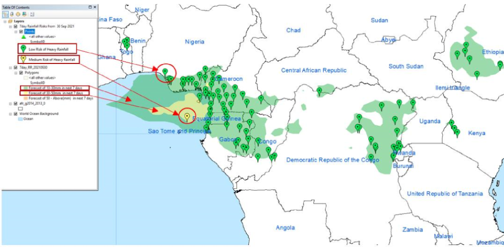
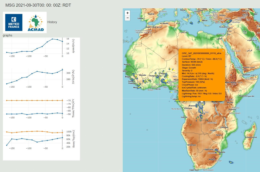
Source RDT : http://154.66.220.45:8080/thredds/fileServer/RDT/20210930/index.html
Forecast Verification :
http://154.66.220.45:8080/thredds/fileServer/ACMAD/WWFD/v erificationservice/OBS/RR24.html
http://154.66.220.45:8080/thredds/fileServer/ACMAD/WWFD /forecastinservice/Africa/20210930/africa_multimodel_display
9.0 Coordination Mechanism for Data Exchange
The core component of improving disaster risk management governances is inextricably linked to the outflow of the exclusive level of climate extreme and disaster risk information exchange and coordination at multiple levels by establishing a robust coordination mechanism. Given that African context of climate extreme and impending multi-hazards are being interacted with rapid on-set disaster events over the diverse landscape and doing the colossal level of damage to life, livelihoods and eventually to jeopardize the food security with quite a larger extent. The extreme climatic phenomena continue to exacerbating as IPCC project that Africa already exceeded 2°C by the last two decades of this century and over the end of the century Africa will be falling in between 3°C and 6°C[1] and it is very likely that the land temperatures over Africa will rise faster than the global land average, particularly in the more arid regions, and that the rate of even increase in minimum temperatures will exceed that of maximum average temperatures today. The nature of incremental pace of changing climates and subsequently intensity of multi-hazard events is more often being characterized as catastrophes over the past decades. Given that circumstances, the comprehensive management of disaster events required a holistic level of participation in risk screening, information exchange & repository, management & process, development of informed tools to instrumentalizing risk integrated planning from central to the local level.
The frameworks approach over to inclusive emergency information service deliveries with coherent horizontal and vertical coordination mechanisms of the information exchange among national governments, focal points, institutional, stakeholders, users’ level for dealing with disaster emergencies and target to achieve SDG 2030 and beyond.
However, activating an integrated multi-hazard early warnings system and delegating the most timecritical and accurate level of forecast and prediction of extreme weather is a more critical job, which required multi-faceted functionaries and coordinated mechanisms for effective and interactive service deliveries.
9.1 Purpose of the Multi-hazard Early Warning Data Coordination Mechanism
The most important ingredients for developing impact-based early warnings are encompassing comprehensive observation and analysis of extreme weather parameters, another rapidly developing weather system (e.g. RDT), etc., which are very essential for developing extreme weather forecasts. To develop impact based multi-hazard Everly warning tool, the given forecast needs to be further analyzing with spatial analytical tools (GIS software). Principally, the more precision level early Warnings, the more appropriate level of early actions (EWEA). Impact-based forecasting can effectively be informed organizations and communities to formulate understandable and actionable messages and take respective preparedness and response measures.
Considering the inflow and outflow of datasets & information, the African Union Commission ( AUC) undertaken initiatives aligning the Sendai Framework & Global Framework for Climate Services (GFCS) approach based paradigm of developing MHEWS, dissemination, and integrating with the risk informed decision-making process at the local level.
[1] IPCC
The main goal of MHEWS is to leverage the best practices, innovative methodologies, and existing tools to share actionable early warnings and build sustainability for climate information and early warning systems initiatives. The African Union Commission (AUC) needs to solicit disaster risk data from member states.
This coordination mechanism is expected to be providing the way forward for the collection and management, usage of the data and products and the rights of the data providers specify the roles and the contacts of the responsible data holders and providers. These mechanisms will be able to set synergies for data exchange coordination amongst the core stakeholders e.g. Africa Union Commission (AUC), Regional Economic Communities (RECs), and Member States (MS), and other relevant stakeholders.
9.2 Objectives of the Data Coordination & Exchange Mechanism
The objectives of this exclusive coordination and exchange mechanism are to strengthen the AUC’s pivotal roles in establish and improve the coordination mechanism of plugging in all inputs of on-going multi-hazard dissemination of severe weather forecasts, facilitate interactive and effective communication, coordination for exchange of disaster emergency data and information on on-set disaster events at the local level, and subsequently preparing an event situation report on the occasion of disaster being declared by the Member states.
Improving the disaster risk management governance at multiple levels following through the topdown & bottom-up approach with the following technical objectives :
a) Delegating programme, strategies to RECs, MS , Focal points, NHMS organizations (Disaster Management, Met Agency, vulnerable sector departments, hydrological organizations, local governments ) on conducting multi-hazards risk & vulnerabilities analysis, the repository of multi-hazard risk database & corresponding GIS Map at the all administrative level.
AUC to delegate and propagate strategy, process, and activities to conduct comprehensive risk and vulnerability assessment at national, regional/provincial/district, and lowest administrative level before developing risk repository and informed tools which essentially required for having risk scenario/phenomena, GIS multi-hazard risk & vulnerability distribution map readily available in hand. This mandatory tool would effectively be complementing the most precise level of projection of forecasting extreme weathers complying with the background check of the prevailing risk context of the vulnerable countries.
b) Delegating the job to the Continental advisory center (ACMAD & ICPAC) for developing severe weather forecasts, and multi-hazard situation reporting:
As a regular interval, the AUC to delegate responsibilities to two regional WMO designated Regional Climate Centers (ACMAD & ICPAC) for developing two products “Continental Watch” on severe weather forecasting on the ahead of 5 days and giving the threshold of 5 days amount of precipitation accumulation with the projection of rainfall color coded level of warnings and advisories on probable consequences and also the advisories of strong winds.
c) Implying policy advocacy on multi-hazard risk screening, assessment to disaster damage and needs, data capture, information coordination
- Implying policy advocacy to Member States(MS), RECs, National hydro-meteorological service providers(NHMS), and beyond to remain operational in risk screening, data & information capture, and coordinating the datasets, and information to AUC continental advisory center .
- Putting a participatory open-ended policy in place and delegating member states of taking stock of all information of disaster incidence, disaster damage and loss profile(picture, videos), assessment report, documentaries, humanitarian response, response gaps, postdisaster impacts on sectors, economies, livelihoods, public health and building back better approach.
- Putting policy regulation to MS to establish coherent coordination mechanism under standing orders on disaster (SoD) for exclusive engagement of DRM stakeholders & actors, the private sector, NGOs, social services organizations, and the civil society, etc., as partners for incorporating inputs(feedback) to MHEWS as a way to ensure risk informed and sustainable development .
- Improving Africa Media Monitor (AMM) Structures, Procedures, and Service automation process
- Underpinning the most prioritized action of upgrading AMM web portals so that it can crawl and grab relevant disaster event information from all new outlets and develop a repository for easy access.
- Specialized Web portal development for exclusively disseminating and interacting disaster event information. Taking into account the centralized role as AUCs as a continental body, this organization undertakes advocacies of disseminating severe weather forecasting tool “continental watch” at sub-organs, regions, and member states level and beyond level. 3) Developing a disaster event database on past disasters 4) Develop a digital library of disaster event information.
- Developing interactive forum over the social networks
- Utilize the social networking platform for inclusive interactive participation of audiences.
- Taking feedbacks from stakeholders, focal points, vulnerable communities for further customization and improvement of products and services for meeting the demand.
- The development, access, and use of the best science and new technologies underpin all components of multi-hazard early warning systems.
- Feedbacks that learning from good practices of understanding & receiving early warnings by the vulnerable community from the remote & hard-to-reach areas.
- Strengthening the Early Warning for Early Action (EWEA) chain, taking on an impact-based forecasting approach in early warning to enable organizations and communities to formulate understandable and actionable messages and take respective preparedness and response measures.
- Upgrading web portal of Africa Media Monitor for customization to capture disaster event information at the up-to-date level.
9.3 Proposed Structures of Coordination Mechanism for Data Exchange
Following through a participatory, inclusive, and open-ended platform which is expected to leverage both ways effective communication and the robust coordination mechanism. The target goal of AUC led process is to develop extreme weather risk-informed tools CW and event situation report for delivering multi-hazard risk early warnings effectively. Partnership development among the continental and regional level (RECs & beyond) must appropriate operational institutional bodes to generate, exchange and disseminate information. The principles of the MHEWS mechanism are to routinely collate, store and process information about past, present, and future extreme weather events. The typical architecture of coordination mechanism to simultaneously function both way traffic of information dissemination and exchange. Primarily myDEWETRA can be accessed by web at https://www.mydewetra.world for downloading and customization multi-hazard risk, analyzing weather parameters for developing specific products, and running with this open-source systems through https://test.mydewetra.world .
The implementation strategy of mechanism encompasses a multi-tiered structure that of AUC delegated and collaborative process to ensure continental and regional level coordination and data exchange facilitating the CW and event situation reports are generated, exchanged, and disseminated:
- Continental level through a range of advanced continental bodies;
- Regional level through RECs;
- Member states level through the national network of entities with national and local level ;
Figure 12: Typical Structures of Coordination of Data Exchange Mechanism
9.4 Actionable coordination Mechanism for Data Exchange
| Entity Types | Coordination Action | Data / information requirements | Exchange mechanism | |||
| Date required for Multi-hazard risk mapping | Date required for Event Situation Reporting | Inbound data & information services | Outbound data & information services | |||
| AUC Continental advisory center | AUC to delegate Policy, strategy, program, action plan, etc., to Organs and Sub-organs, Member states for functioning the coordination mechanism of data exchange Delegating the RECs level authority of mechanizing the coordination for data exchange by providing MS level strategy on how they create interconnectedness of top-todown & bottom-up level actors so that outflow of multi-hazard risk and vulnerability information automatically occurred. Coordination mechanism and data exchange with other UN Agencies (WFP, FAO, UNDP, UN- OCHA, UNHCR), GFDR, UN- SPIDER, African Risk Capacity (ARC), International NGOs (Africa), IFRC, RIMES Africa, CREW Initiatives and other relevant hubs. Putting Member States under strong coordination mechanism with and creating an obligation to data exchange with continental advisory center s. Delegate an executive order to all Emergency Operations Center (EOC), Disaster Control Rooms, Humanitarian actors (OCHA, IRC) at country level to coordinate disaster emergency preparedness, post disaster damage, loss and needs information, with continental advisory center s. | • As a continental body, AUC to delegate and empower RECs so that they can push a policy to MS perform the following tasks; MS should be obelized to provide all those damages, losses, the extent of areas are impacted by the ongoing disaster and immediately to provide all those information to the continental continental advisory center MS National hydrometeorological Services (NHMS) organizations, emergency management authority, country focal points, local governments agencies at the last mile should be obliged to provide disaster/climate risks & vulnerable assessment information to RECs & continental continental advisory center . MS level Met Agencies to be well connected with RECS & Continental Continental advisory center to exchange information about localized forecasts and provide maps on rainfall distribution of the past seasons, weather parameter anomalies (rainfall, temperatures etc.), seasonal variation of essential weather parameters, track record extreme weather events, multihazards et., and provide all the profile, maps, weather outlooks, bulletins to RECs & continental continental advisory center . Database of historical disasters and multi-hazards events of the country. | • AMM to develop a repository on all collected information supply to continental advisory center s for preparing customized maps, situation reports, and advisories on ongoing multi-hazard events | • Information Repository on multi hazard events | – | Weekly 2 Continental Watch bulletins Event situation report |
| ACMAD Continental advisory center | As a continental meteorological body, ACMAD shall be wellcoordinating with WMO regional data hub (Africa) for exchange meteorological products and services of their focused regions. Establish coordination mechanism of exchanging regional & sub-regional climate outlook forum for getting update products. Establish coordination with country level met agencies for accessing country level meteorological forecast, weather outlooks (seasonal variation, anomalies, precipitation index etc.) for analyzing and mapping country | A google earth kmz file on drawing polygon of the extent of the areas impacted, point the location where human casualties occurred, location of infrastructure & other elements damaged by taking information from disaster focal points Downloading GIS Shapefile(TIFF) from myDEWETRA platform on heavy rainfall accumulation for upcoming 5-10 days(GFS) for preparing CW. Download satellite image on Fastest on-set weather parameters (with nowcasting) e.g. Rapidly Developing Thunderstorm (RDT), Tornadoes, dust-storm, heavy rainfall, etc. Access to Tropical Cyclone Center at La Reunion for having access to tracking information of west Indian | • Events hotspot location map | Inputs weather parameters dataset Regional weather outlooks products, information services | Continental watch (CW) Different range forecasting products, weather outlooks, climate change impact models, maps, and datasets. Climate information and services | |
| Entity Types | Coordination Action | Data / information requirements | Exchange mechanism | ||
| Date required for Multi-hazard risk mapping | Date required for Event Situation Reporting | Inbound data & information services | Outbound data & information services | ||
| specific multi-hazard risks and vulnerabilities. • Establish both way communication with regional data hubs, Climate service providers (NHMS) for data exchange. | ocean depression (Tropical Cyclone) and developing early warning maps. • Access to AMM alert message for other fastest-onset disasters earthquakes, volcanos, tsunami, etc.) | ||||
| ICPAC Continental advisory center | As a regional specialized climate center (East African countries) ICPAC needs to establish coordination mechanism of all regional members countries, so that NHMS organizations provide hazard / climate risk and vulnerabilities assessment (CRVA) report on regular basis for analyzing multi-hazard risk & vulnerabilities maps. Coordinate and exchange tailormade multi-hazard and climate information services to AUC, ACMAD, and other regional stakeholders. Coordination with other UN Agencies WFP, FAO, UNDP, UNOCHA, GFDR, Rimes, CREW Initiatives, UN-SPIDER, African Risk Capacity (ARC). | Extreme weather paraments (heavy rainfall, strong wind, high temperature, etc.) Fastest on-set weather events (nowcasting) e.g. Rapidly Developing Thunderstorm (RDT), Tornadoes, dust-storm, heavy rainfall, etc. Country level multi-hazard risk profile, risk and vulnerability information at administrative level. Climate outlooks (monthly, seasonal, yearly) • | Access to Tropical Cyclone Center at La Reunion for having tracked early information on west Indian ocean depression (Tropical Cyclone) and remains to be alerted for developing situation reporting. For flooding incidence having hotspot location Firsthand damage, loss information on immediately after the disaster in first 1- 12 hours and 24 hours. Post-disaster damage loss and needs assessment (PDNA) report. | • Input data of multihazard risk and warning mapping | Disaster event situation report Risk informed tools for the stakeholders and sectors |
| RECs | Delegate policy, strategy, an action plan to MS for Multihazard and Climate Risk & vulnerability (CRVA) assessment. Delegating plan of action so that Standing orders on Disaster(SoD), Disaster Risk & Emergency Management Plan, at national & local level. Delegate plan of action so that MS communicates all updates ( damage info, pictures, video clips to continental advisory center ) for event situation reporting. Providing risk-informed sustainable development strategies to the member countries (MS). Establish effective communication with AUC, ACMAD, ICPAC and develop strategy, policy, programs, action plan on climate change and disaster risk management, action plan for combating desertification, Delegating plan of action for formulating risk-informed local development planning. Coordinate and delegate actions plan for MS for consensus- building of data and information exchange on multi-hazards. Coordination mechanism with MS level information clearing desk ( Ministry of information ) , national mass communication | Coordination and communication with MS so that local weather stations’ synoptic weather station data by Met agency regularly updates NHMS organizations and other relevant stakeholders. | Coordinate MS for activating EOCs (led by Emergency management departments, Met agency, humanitarian actors) and update continental advisory center s with impending, ongoing hazard information. | Receive multi-hazard early warnings, information services, and advisories REC and MS level policy planning desks. | Disseminate multi-hazard early warnings, information services to MS and REC level policy planning desks. |
| Entity Types | Coordination Action | Data / information requirements | Exchange mechanism | ||
| Date required for Multi-hazard risk mapping | Date required for Event Situation Reporting | Inbound data & information services | Outbound data & information services | ||
| department so that they automatically supply disaster event information to Continental advisory center s. | |||||
| Member States | Member States to develop strategy and policy for engagement of relevant stakeholders in multi-hazard risk management, risk assessment, information collection, repository development, etc. Establish a coordination mechanism with local actors for tracking the multi-hazard events, collect disaster damage, loss, and needs information for developing emergency repose and recovery planning. Member States to remain with RECs, AUC, ACMAD, and ICPAC Continental advisory center ’s disposal for updating country- level multi-hazard risk information to continental advisory center s. Delegating plan of actions to sector departments formulating risk-informed local development planning. Coordination mechanism with local media outlets(radio, newspaper, TV, community radios, radios) through a consensus-building for information exchange on multihazards events with continental advisory center . Coordination mechanism with local humanitarian actors group, NGOs, volunteer groups, student bridge, community level volunteers so that they can perform as social journalism, develop a polygon shape/points of disaster hotspot file with google earth and send kmz file to social media and contribute disaster event information to social media groups | Local-level whether data acquired by Met agency, NHMS organizations. Big data from social media platform and analyze key information for reporting. Kmz file to locate disaster hotspot | Local-level whether data acquired by Met agency, NHMS organizations. | Receive multi-hazard early warnings, information services, and advisories. | Disseminate multi-hazard early warnings, information services, and advisories to state and non-state actors. |
9.5 Roles of AUC for the coordination
AUC with its centralized roles to delegate responsibilities to two continental advisory center s (Regional RCC) e.g. ACMAD & ICPAC for developing two products “Continental Watch” on the severe weather forecast on the ahead of 5 days giving warnings based on the threshold of 5 days amount of precipitation accumulation with a projection of rainfall severity of the color-coded level of warnings and advisories on probable consequences.
Based on impact-based early warnings, AUC needs to invoke the process of event situation reporting to be formulated by ICPAC & ACMAD on the occasions of impending disaster, disaster events just occurred, and ongoing at the ground.
9.6 Roles of RECs Level coordination
In the light of the 1980 Lagos Plan of Action for the Development of Africa, the Abuja Treaty[1] proposed action for the creation of RECs as the basis for wider African integration, with a view to regional and eventual continental integration. The RECs are increasingly involved in coordinating AU Member States’ interests in wider areas such as peace and security, development and good governance, and promoting climate risk governance to the member countries.[2]
AUC having 8 Regional Economic Communities (RECs) at the regional level. RECs can play important role in delegating disaster risk information repository and exchange with the respective member states (MS) and continental advisory center s at the country level.
The AU recognizes eight RECs :
- Arab Maghreb Union (UMA)
- Common Market for Eastern and Southern Africa (COMESA)
- Community of Sahel–Saharan States (CEN–SAD)
- East African Community (EAC)
- Economic Community of Central African States (ECCAS)
- Economic Community of West African States (ECOWAS) 7) Intergovernmental Authority on Development (IGAD)2 8) Southern African Development Community (SADC).
9.7 Roles of ACMAD level
ACMAD’s primary role is to provide continental watch ( weather forecasting) from its newly installed continental continental advisory center to AUC. ACMAD as a continental body can incentivize the multiple meteorological products and services for tailoring to support policy and planning desk for the risk-informed development planning process for the continental actors. UNDRR established continental advisory center for developing customized weather information and services data sources to make publicly available to interoperable formats
[1] https://pmg.org.za/committee–meeting/67/
[2] https://au.int/en/organs/recs
ACMAD can further play an important role to encourage the member countries to incentivized the spatial risk information by the regional, national, and local authorities with higher-level or data. desegregation for sectoral risk analysis and developing the coherent institutional linkage and within the guideline of Sendai Framework.
For institutional strengthening process;
- ACMAD coordination mechanism with other WMO designated RSMC/RCC for data sharing.
- Establish coordination mechanisms for data exchange with Data Collection or Production Centre (DCPC) e.g. Casablanca
- Coordination with WMO Information System (WIS) for developing and sharing global catalog services on weather information service, data exchange, management, and processing.
- Establish coordination EUMETCast for improving access to nowcasting services.
- Establish coordination with Regional Climate Outlook Forums (RCOFs) to produce consensusbased, user-relevant climate outlook products in real-time to reduce climate-related risks and support sustainable development.
9.8 Roles of ICPAC level
ICPAC already a WMO designated regional climate center and provides customized climate services to AUC and 11 East African Countries and regions deeply affected by climate change and extreme weather.
9.9 Roles of Member States
Given that RECs policy and programming nexus with MS, the all countries remains to be as most vital forefront executing entity in undertaking policy, strategy, programming, project development , risk informed local development planning, sector preparations in risk screening, assessment, and to invoke country-level state and non-state actors to remain operational and collect, collate and provide information on preparedness planning/contingencies of impending disasters and systematically conduct post disasters damage, need the information to MHEWS. MS to recurrently maintain contacts with national focal points, humanitarian actors, and focal points for getting regular updates and concurrently to update to RECs and AUC.
9.10 Proposed coordination mechanism with WMO designated RSMC/RCC :
ACMAD is being performed as the central continental body for coordinating the WMO level extreme weather information, effectively integrate scientific and technical inputs, and producing CW at regular intervals. Every RSMC/RCC/WIS/DCPC in Africa having particular focuses over their region. As per WMO guidelines, ACMAD remains to be communicated with those centers for getting regional outlooks and weather updates.

Figure 13: Proposed linkages among the WMO Regional Specialized Meteorological Centers
9.10 Recommendations on Coordination mechanism of data exchange
- Develop a highly professional-looking and most integrative web portal complementing the MHEWS dissemination ( www.mhews.auc.int or www.mhews.int ) which to be administered, content being regularly updated by AUC Continental advisory center /EOC at AUC.
- Disseminate most understandable, accurate, and timely CW & event situation report to designated authority and keeping it simple.
- Making messages and tools easily understandable to stakeholders and letting users provide feedback with social media.
- Continental advisory center s at AUC, ACMAD, ICPAC continue to support other Continental advisory center /EOC at RECs & Member State level
- AUC AMM to use interactive social media tools (Social media, e.g. Facebook, Twitter, WhatsApp, telegram, etc.) for a big data repository ( picture, videos, description of damage). By analyzing that information, provide an accurate set of information of ongoing disaster events for reporting and next-level response planning.
- Activating and effective communication among the AUC, ACMAD, ICPAC, RECs, Member states by using email, social media communication tools, and keeping constant contact.
- Create an understandable extreme weather severity level with color-coded threshold and types of alerts, e.g. Red, Orange, Yellow for a wide range of users.
- AUC , ACMAD, ICPAC , RECs, MS, and other relevant stakeholders to remain Integrated with other alerting systems (i.e. earthquake, volcano, dust storm, drought, forest/bush fire, and health alerts) for complementing MHEWS.
9.11 ACMAD Products and Services for DRM
ACMAD continental watch, weather forecast products and services provides early warning services and facilitating humanitarian response. The improved forecasts producing different range real-time and different range of forecasts (RDT, Short-range, medium-range, long-range, decadal, monthly, and seasonal) and outlooks. Standardized products having high demand of the stakeholders.
ACMAD launched continental which is impact-based forecasts for the DRM decision making. For the customized multi-hazard early warnings a continental advisory center now under implementation which would be operational round the clock for DRM decision making .
9.12 ACAMD Products and services for coordinating multi-hazard preparedness planning :
ACMAD continental watch, weather forecast products, and services provide early warning services and facilitating humanitarian response. The improved forecasts producing different range real-time and different range of forecasts (RDT, Short-range, medium-range, long-range, decadal, monthly, and seasonal) and outlooks. Standardized products having high demand of the stakeholders.
ACMAD launched continental which is impact-based forecasts for the DRM decision making. For the customized multi-hazard early warnings, a situation room is now under implementation which would be operational round the clock for DRM decision making.
Table 8 : ACMAD Products and services.
| SL | Product/service types /category | Products | Description | DRM Perspective | DRM end-users |
| 1) | Short range forecasting (Rainfall observation of Nowcasting, Daily, Weekly) | Nowcasting | • Observation of weather parameters in every 15 | • Every 15 minutes to hourly weather forecasting | Local Community Local Sectors Local Humanitarian actors |
| SL | Product/service types /category | Products | Description | DRM Perspective | DRM end-users |
| 2) | Short rage forecasting (Rainfall observation of Nowcasting, Daily, Weekly) | Global multimodal ensemble forecasting systems (GFS, APPAGE, UKMO, ECMWF, ICON, AVERAGE ) | • Multi-hazard early warning, multihazard preparedness, contingency planning. | IFRC, UN-OCHA, UN Agencies National Disaster Operations Center, national Disaster Management Organizations(NDMO) Emergency Operations Center(EOC), National Meteorological & Hydrological Services(NMHS), Humanitarian Actos Vulnerable sectors, vulnerable community | |
| Daily observed rainfall | Flood/flash flood forecasting | Facilitate IFRC, UN-OCHA for flash flooding preparedness Met Agency to forecast on thunderstorm with special weather bulletin National Disaster Management Organizations(NDMO) , Emergency Operations Center(EOC) for the issue early warning and preparedness. National Meteorological & Hydrological Services(NMHS) for flash/riverine floods warning. Humanitarian Actos for pre-positioning the reliefs Vulnerable sectors( Agriculture, water, health, livelihood ) for early preparedness vulnerable community for early preparedness | |||
| Numerical Weather Prediction (NWP) model outputs (D1, D2 and D3 rain accumulation forecast), ITD positions (D1 up D3), and other relevant outlooks. | • Ensemble various models and develop daily, 3 days ( D1+D2+D3) forecasts | Important forecast for DRM actors with weather bulletin on precipitation amount, temperature, relative humidity. | Facilitate IFRC, UN-OCHA for flash flooding preparedness Met Agency to forecast on thunderstorm with special weather bulletin National Disaster Management Organizations(NDMO) , Emergency Operations Center(EOC) for the issue early warning and preparedness. National Meteorological & Hydrological Services(NMHS) for flash/riverine floods warning. Humanitarian Actos for pre-positioning the reliefs Vulnerable sectors( Agriculture, water, health, livelihood ) for early preparedness vulnerable community for early preparedness |
Product/service types /category
Products
Description
DRM Perspective
DRM end-users

Rapidly Developing Thunderstorm (RDT) and rapid on-set weather events.
 • Tracking rapid on-set weather systems (Rapidly Developing Thunderstorm (RDT) , projected precipitation levels, etc.
Daily forecast on thunderstorm\
High convective with overshooting top
, August month
Facilitate IFRC, UN-OCHA for flash flooding preparedness
Met Agency to forecast on thunderstorm with special weather bulletin
National Disaster Management Organizations(NDMO) , Emergency Operations Center(EOC) for the issue early warning and preparedness.
National Meteorological & Hydrological
Services(NMHS) for flash/riverine floods warning.
Humanitarian Actos for pre-positioning the reliefs
Vulnerable sectors (Agriculture, water, health, livelihood) for early preparedness
vulnerable community for early preparedness
Maximum daily temperature

Map on maximum temperature
distribution for projecting heatwaves
Vulnerable sectors (Agriculture, water, health, livelihood) for early preparedness
vulnerable community for early preparedness
| SL | Product/service types /category | Products | Description | DRM Perspective | DRM end-users |
| Short range forecasting (Rainfall observation of Nowcasting, Daily, Weekly) : | Frequency of Decadal Cumulative (ARC2>= 50mm) | Area of extent under identified where rainfall goes over 50mm for the 10 days and undertake preparedness. | IFRC, UN-OCHA, UN Agencies National Disaster Operations Center, national Disaster Management Organizations(NDMO) Emergency Operations Center(EOC), National Meteorological & Hydrological Services(NMHS), Humanitarian Actos • Vulnerable sectors, vulnerable community | ||
| 3) | Heavy Rainfall/Flash Flood Bulletin #349 | Heavy Rainfall distribution map expected to be supporting preparedness and contingency planning | Facilitate IFRC, UN-OCHA for flash flooding preparedness Met Agency to forecast on thunderstorm with special weather bulletin National Disaster Management Organizations(NDMO) , Emergency Operations Center(EOC) for the issue early warning and preparedness. National Meteorological & Hydrological Services(NMHS) for flash/riverine floods warning. Humanitarian Actos for pre-positioning the reliefs Vulnerable sectors( Agriculture, water, health, livelihood ) for early preparedness vulnerable community for early preparedness |
| SL | Product/service types /category | Products | Description | DRM Perspective | DRM end-users |
| 4) | Rainfall variability | Frequency of Decadal Cumulative (ARC2>= 75mm) | Area of extent under identified where rainfall goes over 75mm and undertake preparedness and contingency planning. | Vulnerable sectors( Agriculture, water, health, livelihood ) for early preparedness vulnerable community for early preparedness | |
| 5) | Rainfall variability | Area of extent under identified where rainfall goes over 100mm and undertake preparedness and contingency planning.. | Vulnerable sectors( Agriculture, water, health, livelihood ) for early preparedness vulnerable community for early preparedness | ||
| 6) | Seasonal Precipitation Forecast for Nob-Dec-Jan 2021-22 | Seasonal precipitation forecast for Nov-Dec-Jan 2021-22 | Identify risk of agriculture, health, water, natural resource and environment resource sectors. | Vulnerable sectors( Agriculture, water, health, livelihood ) for early preparedness vulnerable community for early preparedness |
Product/service types /category
Products
Description
DRM Perspective
DRM end-users
Map showing the % rainfall incidence over the period
7)
Monthly temperature anomaly
Temperature anomaly for October 2021Map showing the % rainfall incidence over the period
Identify risk of agriculture, health, water sectors.
Vulnerable sectors( Agriculture, water, health, livelihood ) for early preparedness
vulnerable community for early preparedness
8)
Medium-range Forecasts
10-days climate diagnostic bulletin
• CPC 10 Days Precipitation % of average – Period 01 November – 10 November 2021. Map showing
the distribution of rainfall over the continent well above average, above average, near average, below average, well below average.
Map showing rainfall variability of 10 days and identify the regions where it is less and impacting the sectors and livelihoods . Identify risk of agriculture, health, water, natural resource and environment resource sectors.
Vulnerable sectors( Agriculture, water, health, livelihood ) for early preparedness
vulnerable community for early preparedness
| SL | Product/service types /category | Products | Description | DRM Perspective | DRM end-users |
| 9) | Long range forecast product for Africa Valid for October -Nov-Dec 2021 / Dec- Jan 2022 | Seasonal Temperature forecast for Nov-Dec 21/-Jan – Feb 2022 | Temperate anomaly that can Impact agriculture, health, water sectors. | Vulnerable sectors( Agriculture, water, health, livelihood ) for early preparedness vulnerable community for early preparedness | |
| 10) | Future hazard map of Africa | Hazard scenario for 2011 -2040 in Africa | Map showing drier part areas, season delay areas, early season rainfall, drier than average rainy season, drier period , cessation of precipitation, wetter areas. | Vulnerable sectors( Agriculture, water, health, livelihood ) for early preparedness vulnerable community for early preparedness | |
| 11) | Hazard map of Africa | No of Rainy days Frequency of heavy rainfall 20m – 50mm Daily rainfall | Understanding the rainfall pattern , frequency of rainfall occurring which expected to be understing the reinfall regime what understanding the water dependent sectors could be impacting. | • Vulnerable sectors( Agriculture, water, health, livelihood ) for early preparedness |
| SL | Product/service types /category | Products | Description | DRM Perspective | DRM end-users |
| 12) | Policy Brief statements for the region and subregions | Rainfall anomaly map | Vulnerable sectors( Agriculture, water, health, livelihood ) for early preparedness vulnerable community for early preparedness | ||
| 13) | Gridded Precipitation | Precipitation distribution map | Vulnerable sectors( Agriculture, water, health, livelihood ) for early preparedness vulnerable community for early preparedness |
| SL | Product/service types /category | Products | Description | DRM Perspective | DRM end-users |
| 14) | ARC2 seasonal cumulative rainfall, onset & distribution | Vulnerable sectors( Agriculture, water, health, livelihood ) for early preparedness vulnerable community for early preparedness | |||
| 15) | Long Range Map | Meningitis vigilance Map | Identifying the area of extent falling under emergency meningitis infection | Health Sector Vulnerable Community IFRC, UN-OCHA, | |
| 16) | Long Range Map | Meningitis vigilance Map | Identifying the area of extent falling under emergency meningitis infection | Health Sector Vulnerable Community IFRC, UN-OCHA, • |
Product/service types /category
Products
Description
DRM Perspective
DRM end-users
17)
Other Long range forecasting
Monthly bulletin
seasonal precipitation forecast ,
Seasonal temperature forecast map,
African seasonal precipitation average map (125%),
African seasonal precipitation average map (75%),
Seasonal climate forecast bulletin
(RCC),
Monthly Climate Diagnostic bulletin for Africa (RCC),
Ten Day Climate Watch Bulletin
(RCC)
Accumulated Rainfall Forecast
Seasonal precipitation forecast map, Seasonal temperature forecast map, African seasonal precipitation verge map, Significant weather and climate events map, climate hazards map, seasonal precipitation and temperature forecast map, significant weather and climate event expected map, seasonal map of the
performance of precipitation
Observed Decadal precipitation map in percent of average,
observed and forecasted week ahead for precipitation (precent of average from week -1 to week -4 and dekad -1 to dekad -3 with the latest models forecast), 3. precipitation map in percent of average from 1 to 2 months
weekly and monthly sst anomaly observation and forecast,
week1, 2 and 3 Velocity potential anomalies, precipitable weather and anomalies forecast,
Hove Moller diagram of velocity potential anomalies,
MJO observation and forecast,
OLR anomalies,
Streaming function and anomalies observed weeks -1, -2, -3, and -4 and forecast week1, 2, 3 and 4, 9.mean sea level pressure and anomaly map,
Observed mean geopotential at 500 hPa and anomaly map,
The mean position of ITD, CAB and ITCZ map,
Mean wind at 700 hPa, 850 hPa and 500hpa with geopotential,
IFRC,
UN-OCHA,
UN Agencies
National Disaster Operations Center,
national Disaster Management Organizations(NDMO)
,
Emergency Operations Center(EOC),
National Meteorological & Hydrological
Services(NMHS),
Humanitarian Actos
Vulnerable sectors,
vulnerable community
| SL | Product/service types /category | Products | Description | DRM Perspective | DRM end-users |
| Dekadal dust loading map, Surface dust concentration map, Mean wind at 200 hPa, observed and forecast for week 1, 2 and 3 ahead for relative humidity and anomaly at 700 hPa and 850, Winds and geopotential forecast at 850, 700 and 500hpa for weeks 1 and 2, Forecast map divergence for week 1 and 2, 18) weekly precipitation forecast maps ‘week1 and moisture change, 19) Past weeks 1-, 2- -3 -4 velocity potential and anomalies and total precipitable water anomalies, 20, Cumulative precipitation time series up to current date and forecasts for 3 weeks ahead or 21 days ahead with means GEFS, mean ECMWF S2S ensembles, total deterministic medium to long range forecast | |||||
| 18) | Other Customized products | Continental Seasonal Climate Forecast Bulletin (Long Range Forecast Bulletin) Continental drought watch bulletin Brief Summary for policy and decision makers on climate watch Summary for policy and decision makers on drought watch Regional climate outlook statements and fora reports Technical note on Drought monitoring and continental seasonal forecasts Drought monitoring and continental seasonal climate forecast bulletin for DRR Annual Significant weather and climate events | IFRC, UN-OCHA, UN Agencies National Disaster Operations Center, national Disaster Management Organizations(NDMO) Emergency Operations Center(EOC), National Meteorological & Hydrological Services(NMHS), Humanitarian Actos Vulnerable sectors, vulnerable community |
| SL | Product/service types /category | Products | Description | DRM Perspective | DRM end-users |
| Climate outlook verification African Monsoon Mean wind at 200 hPa Precipitation in percent of average |
9.13 Data Dissemination & Feedbacks Receiving Mechanism
The most important element of communication for coordination mechanism data exchange to reaching out to target stakeholders and remaining them with the coordination and exchange loop. The African continental multi-hazard contexts are so diverse in terms of landscape, extreme weather phenomena, risks, and vulnerabilities, diverse and most erratic weather system of the globe. As a result, the extreme weather events over the continent are highly rapid on-set, recurrent and larger extent of damages being done. Stakeholders and vulnerable communities remain to be hopeless in addressing the multi-hazards trauma.
Accurate and timely access to impact-based multi-hazards early warnings can minimize loss and damage at the local level. The process is reiterative, interactive, and opened ended nature of the modality for keeping last-mile informed and interactively being learned lessons from them, and being informed by them how to formulate forecast-based appropriate intervention response planning. Understanding community vulnerabilities are a difficult process because of the diverse landscape and topographical context. However, the myDEWETRA platform provided input datasets that can easily be interpreted with GIS software for community and other multiple levels of vulnerabilities. The platform having the interface of a multi-hazard alerts system for the larger audiences, and that can be utilized for the dissemination of the MHEW information.
9.14 The necessity of launching MHEWS web portal
To date, AUC not having a classified MHEWS web portal for disseminating only the multi-hazards, their impacts, and advisories for the decision-making desks, which is now an urgent requirement. The highly programmatical web portal will be able to capture the feeds information from local level actors. Proposed web portal address e.g. www.mhews.auc.int or www.mhews.int
9.15 Social journalism/Citizen through social media
Using the social media platform for ensuring inclusive participation in the hybrid feeding back processes through the social journalism media model that consists of a wide range of contributors and readers in the network. The social journalist can be involved to capture the photographs and videos of the on-set disaster events and to post the social network (Facebook group/page, Twitter group, Telegram, LinkedIn Group, etc.) as big data for further analysis and decision making.
9.16 Messaging with Telegram Apps
This app user can provide feeds back to the circulated early warnings. AUC media monitor and continental advisory center to create the user group for disseminating information and taking feedbacks.
9.17 Instance Messaging, voice /video calling :
These are the most important and useful tools for live chatting and watching the ground-level disaster damage and impact scenarios by using WhatsApp group, Facebook group, Telegram group, and other IM tools. Those tools are expected to be enabled media monitors to capture remote and hard-to-reach area information.
9.18 Uses of national media outlets and Community Radio
This is the most comprehensive and affordable means of communication are the national radio, Television, cell broadcasting, cell phone Interactive voice response (IVR), and most importantly Community radios, which can be called as lifeline of the information accessing modality. Member States can vastly rely on Community radio for bridging the last mile information dissemination gaps.
9.19 Some simplified users of MHEWS
Policy Makers. This group is comprised of RECs policy desks, MS level national and local governments, sector departments, NHMS, and other relevant policy intuitions.
Local vulnerable communities: This group is comprised of smallholder farmers, vulnerable communities, etc.
Farmers: This target group is comprised of crop farmers, smallholder farmers, industrialized farmers, pastoralists (livestock herders), fishermen, and rural enterprises. This target group has multiple needs for weather and climate information. It can save lives, contain losses, increase productivity and reduce risk. Reaching rural farmers is a challenge, Internet communication is virtually impossible, literacy is low, and there are regional and village-level cultural and language differences. ( community radio could be useful ) Private Sector. Private sector enterprises benefit from tailored weather information to protect human and physical resources and make climate-smart business decisions, they can also play a role in disseminating messages.
10.0 Conclusion and Recommendations
Designing, implementing and activating the Multi-Hazard Early Warning System (MHEWS) already being recognized as heavily technical settings and encompassing integration of deployment for extreme weather screening to analyzing and disseminating early warnings advisories promptly. The deployment of myDEWETEA platform can effectively support in producing extreme weather-induced multi-hazard interpreted continental watch bulletin, multi-hazard event situation reporting.
The established ACMAD Continental Multi-Hazard advisory center at Niamey and other parallel centers at AUC and ICPAC now effectively contributing for extreme weather observations, development of impactbased early warnings & advisories for getting member states prepared for issuing necessary early warnings, , contingency/preparedness planning for impending multi-hazards.
The African Union Commission (AUC) playing the centralized role in implementation of the MHEWS for the continent with representing the framework approach of coordination mechanism of data exchange, data sharing policy, legal framework of system activation and aligning Sendai Framework & Global Framework for Climate Services (GFCS). The mechanism providing the way forward for the collection and management, usage of the data and products and the rights of the data providers specify the roles and the contacts of the responsible data holders and providers in inflow and outflow of datasets & information, undertaken initiatives and new paradigm of developing MHEWS, dissemination, and integrating with the risk-informed decision-making process at the local level.
ACMAD is co-partner to the AUC led MHEWS to leverage the best practices, innovative methodologies, and existing tools to share actionable early warnings and build sustainability for climate information and early warning systems initiatives. The coordinated efforts of ACMAD, AUC & ICPAC is expected to be providing best output of multi-hazard advisories.
Recommendations :
The climate change induced risks and vulnerabilities over the African continent are being characterized as multifaceted , erratic, extremes are increasingly growing as rapid on-set events. The weather and climate system over the continents becoming an erratic pattern as increasing temperatures, changing precipitation patterns and more extreme weather are threatening human health and safety, food and water security, and socio-economic development in Africa. Over the document, several technical issues and strategy being highlighted on how to improve the whole of MHEWS technical paradigm of climate risk governance and coordination across the institutions & stakeholders, stakeholders/individual levels. Further to consolidate the issue following recommendations can be outlined;
- Taking a status-quo at Member state level of what types of MHEWS putting in place, review the system ICT infrastructures, components functional capacity, indicative gaps and retrofitting the whole system
- Linking MS level MHEWS with AUC, ACMAD, ICPAC level MHEWS for establishing a both way traffic for information exchange and effective impact based early warnings.
- Design and implementation of functional MHEWS at the community level
- Linkage with academia , sector departments, R & D organizations for comprehensive risk and vulnerability analysis at the administrative level .
- Further customization of myDEWETRA platform and develop an interface for multi-hazard alerting protocols and simultaneously develop a web converting apps of myDEWETRA platform so that every individuals can access to that multi-hazard alerts automatically.
- AUC to send a string official memo to all AUC member states for functionally lkined with MHEWS and share all information timely and necessarily.
- Developing a strong and actionable level of a coordination mechanism for data exchange among the stakeholders with both-way traffic from AUC (ACMAD/ICPAC ) <> RECs<> Member States <> NMHS<> Government Sector Department <> Local Governments <> Vulnerable Community.
- Establish coordination and linkage with National Media, News outlets, Community Radios for disseminating and having risk information.
- Engagement of national-level HMHS organizations for analyzing extreme weather-induced risk and vulnerabilities, and keep them with AUC-led coordination mechanism.
- Upgradation of ACMAD RCC to impact-based multi-hazard early warnings continental advisory center intended to address the impact-based early warning gaps. The ACMAD continental advisory center remains to be linked with other Continental advisory center of AUC(EOC), ICPAC, EECs, AU sub-organs, Member States, and beyond.
- Establish coordination and linkage WMO designated centers for having specialized region-focused weather data and information.
- Develop interactive online portal on MHEWS
- Develop social media platform for information dissemination and coordination.
- Delegating the job to RCCs( ACMAD & ICPAC) for developing severe weather forecasts, multihazard situation reporting.
- Implying policy advocacy of multi-hazard risk screening, data capture, information coordination
- Improving Africa Media Monitor (AMM) Structures, Procedures, Service automation
- Establishing and functioning interactive social networking platform for inclusive participation and information exchange, the early warnings dissemination process
- Implying policy advocacy of multi-hazard risk screening, data capture, information coordination
- Putting policy regulation to member states to establish coherent coordination mechanism under standing orders on disaster (SoD) for exclusive engagement of DRM stakeholders & actors, the private sector, NGOS, social services organizations, and the civil society as partners for incorporating inputs to MHEWS as a way to ensure their long-term sustainability.
- Improving Africa Media Monitor (AMM) Structures, Procedures, Service automation 21) Developing a disaster event database on Africa on past disasters 22) Develop a digital library of disaster event information.
23) Establishing and functioning interactive social networking platform for inclusive participation and information exchange, the early warnings dissemination process
Reference :
AU AFRICAN UNION HANDBOOK 2019
African Union (AU) Agenda 2063
ACMAD Strategic Plan 2020-2023
Guidance Note on Facilitating Integration and Coherence for SDG Implementation – Institutional Coordination mechanism
Road Map for Improving the Availability, Access and Use of Disaster Risk Information for Early
Warning and Early Action, including in the Context of Transboundary Risk Management
Strategy Document : African Ministerial Conference on Meteorology (AMCOMET) Strategy
Strategic plan : World Meteorological Organization (WMO) strategic plan
United Nations (UN) Sustainable Development Goals (SDGs)
WMO 2019 Manual on the WMO Information System Annex VII to the WMO Technical Regulations
Road map Coordination mechanism and Continental Roadmap for submitting the Inaugural Biennial Report to the AU Assembly
WMO : Climate Data Management System Specifications
ACPC Assessment of Africa’s Climatic Records and Recording Networks Including Strategic for Rescuing of Climatic Data
WMO Vision for the WMO Integrated Global Observing System in 2040
WMO Guidelines on Multi-hazard Impact-based Forecast and Warning Services
WMO STRATEGIC PLAN 2020–2023
WMO: Checklist for Climate Services Implementation. Available online at https://www.wmo.int/pages/prog/wcp/ccl/mg/mgccl17/documents/CCl-MG-1- 2018_Item3_Checklist_Climate_Services_Implementation.pdf.
WMO (2011): Climate Knowledge for Action: A Global Framework for Climate Services – Empowering the Most Vulnerable. The Report of the High-level Taskforce for the Global Framework for Climate Services. WMO-No. 1065. Geneva.
WMO (2018): Step-by-step Guidelines for Establishing a National Framework for Climate Services. WMO-No. 1206. Geneva.
WMO-GFCS: What are Weather/Climate Services? Available online at https://gfcs.wmo.int/what_are_climate_weather_services, checked on 6/18/2020.
Website Visited:
www.acmad.net https://amcomet.wmo.int/ https://igad.int/ https://tropic.ssec.wisc.edu/ https://cimms.ou.edu/ https://au.int/en/organs/recs
https://gfcs.wmo.int/CSIS https://www.regionalcommissions.org/
https://www.eumetsat.int/international-cooperation/european-meteorological-infrastructure-emi https://www.cemac.int
ACMAD Strategic Plan 2020-2023
Guidance Note on Facilitating Integration and Coherence for SDG Implementation – Institutional Coordination mechanism
Road Map for Improving the Availability, Access and Use of Disaster Risk Information for Early
WMO 2019 Manual on the WMO Information System Annex VII to the WMO Technical Regulations
Road map Coordination mechanism and Continental Roadmap for submitting the Inaugural Biennial Report to the AU Assembly
WMO : Climate Data Management System Specifications
ACPC Assessment of Africa’s Climatic Records and Recording Networks Including Strategic for Rescuing of Climatic Data
WMO Vision for the WMO Integrated Global Observing System in 2040
WMO Guidelines on Multi-hazard Impact-based Forecast and Warning Services
……………………………………………………………………………………………………………………………………………………………………………………………
This research is strictly being copyrighted by the researcher: Z M Sajjadul Islam , Multi-hazard early warning Expert
For Detailed knowledge, System design, ICT Technologies, Geospatial & IT Programmatic coding and other issues related to Global Multi-hazard early warnings please email : zmsajjad@gmail.com
Call me at WhatsApp : +88 01711 979179 , Skype : zmsajjad